Hike #1455
September 15, 2021
Friendship Park to Beach at Ocean Trails
Hike Leader: Ron Obert
Meet at 8:00 am for start at 8:30 am
Please print your own hike descriptions and maps. This will save the hike leader the inconvenience and cost of providing descriptions/maps to you all.
GPS Data:
Basic Hike:
Distance: 6.5 miles
Elevation: 1,300 feet.
Extended Hike:
Destance 7.6 miles
Elevation: 1,550 Feet
View: Excellent view of the Port of Los Angeles and the South Shore of PVP. (You might want to bring your binoculars and/or camera if it is a clear day).
Directions to Trailhead: Go to the southern end of Harbor Fwy (110) to Gaffey Street, San Pedro exit, South (left) on Gaffey to 9th Street West, (right) on 9th Street to Western Avenue (1.4 mile). Cross Western and turn left in half a block onto Friendship Park Drive. Enter the parking lot by taking the first right turn.
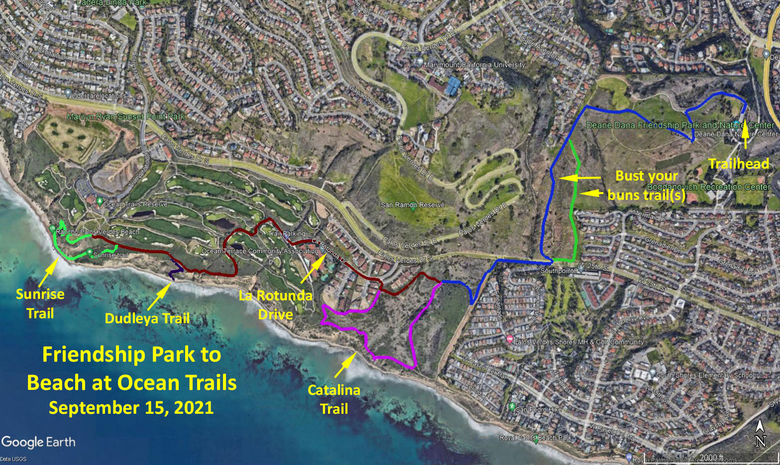
Friendship Park, our starting point and party place has a locked gate and a sign that says open at 8am. Park personnel say it is normally open a little earlier than that. The same is true for the restroom near the far end of the parking lot. The Nature Center opens at 9am. Park at the far end of the parking lot, and party at the numerous tables just below the lot. For some, hiking the numerous trails of the park will be enough. Most will descend from the Park high point down the western "bust your buns trail" (so named on the map), to the trails along the ocean and Trump Golf Course.
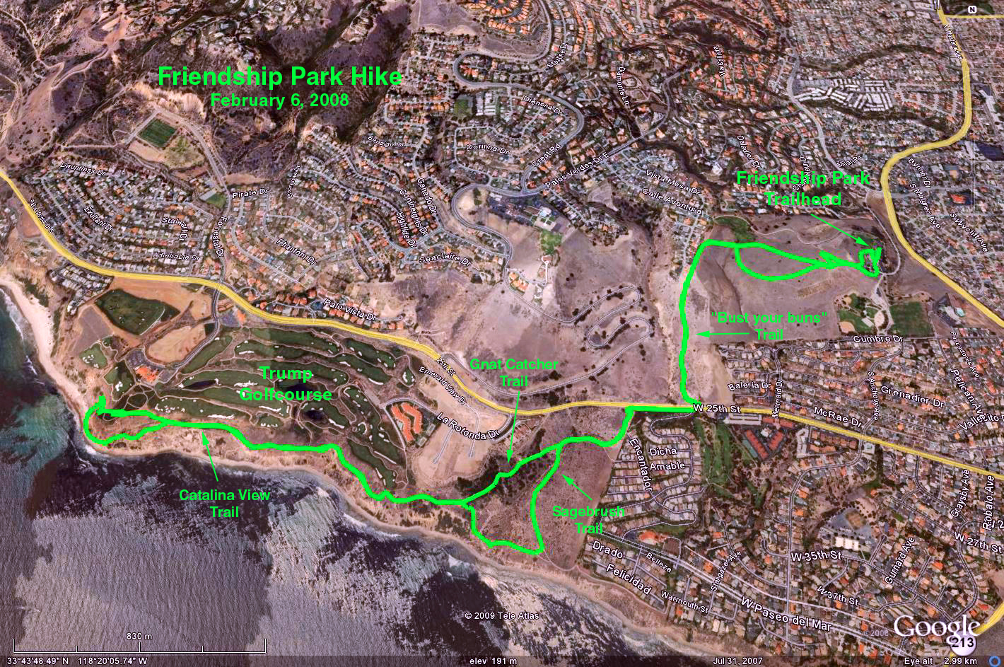
The Hike: The hike has been revised from the November 14, 2018, #1385 hike, because in mid 2021 a landslide resulted in the closure of a portion of the Catalina Trail, as it enters the area to the south-east of the Trump Golf Course.
Begin the hike behind and above the Nature Center. The trail (blue track) leads up the hill and then down to Palos Verdes Drive South via the western "bun buster" trail.. Cross the drive, and proceed down the path into the Ocean Trails Reserve, (aka Palos Verdes Shoreline Park). After the fast descent levels off, bear right at a narrow but well-defined path, or a bit later at a trail signed as Shoreline Park Trail. As you proceed west, notice the trail ahead that climbs the ridge toward a row of houses (dark red track). After crossing the dry creek bottom the basic hike branches right, and up the ridge toward the houses.
Extended Hike: At this point the Rabbits will need more, so they should branch left (purple track). This will lead down the Shoreline Park or Gnat Catcher trail and ultimately to the Sagebrush, Catalina, and bottom end of the East Portal trails. It is at this junction of the Catalina and East Portal trails that the Catalina is closed because of the landslide. The Rabbits should follow the East Portal Trail up until it rejoins the basic hike at the obvious stairway (dark red track)
The basic hike reaches the East Portal Trail at the top of the ridge near the houses (dark red track). Proceed toward the ocean and ascend the stairs just as the trail makes a hard left. The stairs lead us to what is essentially the junction of Twin Harbors Drive and La Rotonda Drive. Proceed down La Rotonda to the parking lot, public restrooms, and the Trump golf course. Follow the public paved “Trail and Bike Way” down to the junction with the Catalina Trail. It is this junction that is the western end of the Catalina Trail closure.
For an optional visit to the beach take the Dudleya Trail (dark blue track). The beach is covered with dozens of stone pile "ducks."
Continue to follow the Catalina Trail west (dark red track) and when we are close to being even with the golf course flag, take the unidentified Sunrise Trail down to the water (light green track). Round the point on the unimproved, but quite adequate trail extension. You should get your boots wet only for the highest of tides. The Sunset Trail up to the public Founders Park is then obvious. Or, one could extend the hike by continuing down and back on the beach, before ascending to the park. The park has benches and tables and is a good rest place. The Trump golf clubhouse is directly above the park, and public restrooms are adjacent to the cart maintenance area.
Return to the party and our cars by proceeding back on the Catalina Trail and retracing our steps, possibly by going east on Palos Verdes Drive at the end of La Rotunda Drive. Take the eastern "bun buster" trail back up to the Nature Center (light green track).
Google Earth Photo - Friendship Park 09/15/2021
Google Earth Photo - Friendship Park 02/06/2008
Updated: 2021-11-21