Hike #1385
November 14, 2018
Friendship Park to Beach at Ocean Trails
Hike Leader: Ron Obert
Meet at 9:00 am for start at 9:30 am
Please print your own hike descriptions and maps. This will avoid the inconvenience and save costs to the hike leader.
Distance: 6.5 miles
Elevation: 1300 feet.
View: Excellent view of the Port of Los Angeles and the South Shore of PVP. (You might want to bring your binoculars and/or camera if it is a clear day).
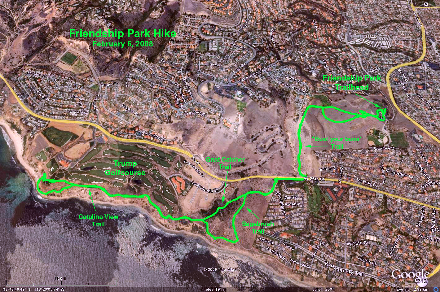
Directions to Trailhead: Go to the southern end of Harbor Fwy (110) to Gaffey Street, San Pedro exit, South (left) on Gaffey to 9th Street West, (right) on 9th Street to Western Avenue (1.4 mile). Cross Western and turn left in half a block onto Friendship Park Drive. Enter park and park in a lot on the first right turn.
The Nature Center opens at 9 AM. Restrooms are available inside the Nature Center and also there is a handicap port-o-potty at the far end of the parking lot.
The Hike: The hike begins at the Friendship Park Nature Center. The trail leads up the hill and then down to Palos Verdes Drive South. We cross PV Dr. South and down into Palos Verdes Shoreline Park. We hike to a viewpoint and then up the Sagebrush Trail to the Catalina View Trail. When we arrive at the 3rd Beach Access Trail (BAT), which is near the flagpole and sand traps we descend to the beach, walk west along the shoreline and return up the next BAT to Founders Park picnic area for lunch. For those wishing to make it a longer hike you could continue on to Portuguese Bend Club and back, approx 1 mile RT.
After lunch we head back along the Catalina View Trail to the Gnat Catcher Trail then up and out of Shoreline Park. For those not wishing to hike back up the hill from this point Ill have our van available for a shuttle back to the Nature Center). We cross PV Dr. So. returning up the hill back to Friendship Park for our after hike party.
Here are a few extra details: It is expected that all will meet and party at Friendship Park. Park at the far end of the parking lot, and party at the numerous tables just below the lot. For some hiking the numerous trails of the park will be enough. Most will decend from from the Park high point down the "bust your buns trail" (so named on the map), to the trails along the ocean and Trump golf course. Pat Forbess will lead a subgroup down a less steep way through the residential area, to the lower sections of the hike. Pat will have her van positioned at the small parking lot at the end of La Rotonda Drive (above and adjacent to the Trump golf course). Pat's van contingent will return to the park to party. I can also help with shuttles - reach me at my cell 310 383 6106. Others will return via the "bust your buns trail".
There are several restrooms in Friendship Park, a restroom at the La Rotonda parking lot, and one in the Trump clubhouse building. The clubhouse restroom is on the lower level and adjacent to the cart maintenance area.Google Earth Photo - Friendship Park to the Beach
GPS Data:
RT = 5.8 mi.
Trailhead = 275 ft.
Max Elevation Change = 510 ft.
2018-11-12