Hike #1338
October 4, 2017
Verdugo Mountains - South Traverse - Beaudry Loop
Updated after the La Tuna Verdugo Fire
Hike Leader: Phil Rutherford
Meet at 9:00 am for start at 9:30 am
Suummary: This will be the sixth time this hike has been done. The previous hikes were 316 (Ron Forbess), 506, (Richard Braun) 639 (Richard Braun), 1017 (Jack Robinson) and 1077 (Jack Robinson).
Trailhead Directions:
From the west, take the I-210 freeway, take exit 17 for Pennsylvania Ave. Turn right on Pennsylvania Ave. Pennsylvania Ave. becomes Honolulu Ave. After 1.0 miles, turn right on La Cresenta Ave. After 0.4 miles, turn right on Oakmont View Drive. After 0.6 miles turn left on Barnes Circle. After 0.3 miles, turn right on Beaudry Terrace. After 0.1 mile, trailhead is where Beaudry Terrace becomes Beaudry Blvd. Street address is 1301 Beaudry Blvd., Glendale. Park on the street.
From the south, take the SR-2 freeway, take exit 18 for Mountain Street. Turn left on E. Mountain St. After 0.5 miles, turn right onto N. Verdugo Rd. After 0.2 miles, keep left to continue on Canada Blvd. After 1.6 miles, turn left onto Country Club Drive. After 0.5 miles, turn left onto Beaudry Blvd. After 0.4 miles, trailhead is where Beaudry Blvd. becomes Beaudry Terrace. Park on the street.
There are no restrooms at the trailhead.
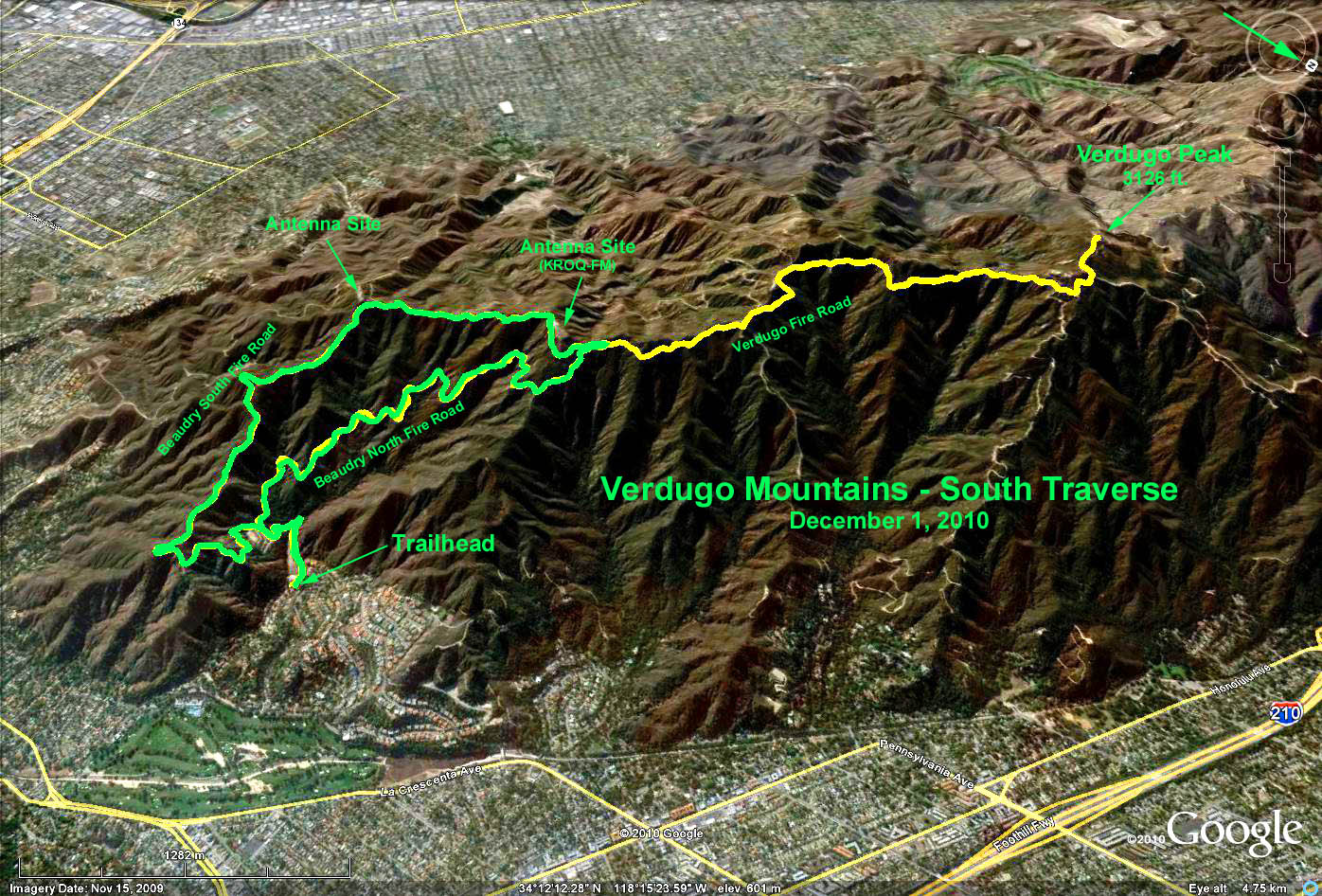
Basic Hike (Green Track): From the trailhead (el. 1,188 ft.), we start up the fire road alongside a debris basin. At 0.4 miles the road forks into Beaudry South Mtwy and Beaudry North Mtwy. We'll take the north road up ... right fork (not as steep!). After another 2.1 miles the two roads meet again at the Beaudry North-South junction (el. 2,506 ft.). Those wanting a shorter hike, can have lunch at the junction and head back to the trailhead via the Beaudry South Mtwy. After 0.75 miles from the junction, take the left fork back to the trailhead. This option is a RT of 5.8 miles and a net elevation gain of 1,318 ft.
Extended Hike (Yellow Track): Those wishing a longer hike can continue from the Beaudry North-South junction west along the Verdugo fire road for as long as they wish. The distance all the way to Verdugo Peak (el. 3.142 ft.) is 2.5 miles or an additional RT of 5.0 miles. Those wanting a change from the fire road, can take the narrower trail that follows the mountain ridge and generally parallels the fire road until it reaches Verdugo Peak. This ridge trail starts about 100 yards back down the Beaudry South Mtwy on the right. A short scramble up a rocky slope will get you to the ridge trail. However, as a mitigation measure to prevent the spread of the La Tuna Fire, this ridge trail has been bulldozed into a fire break ... it is therefore a wide, loose soil, trail that may not be to everyone's taste. After reaching Verdugo Peak, retrace your steps back to the trailhead via the Beaudry South Mtwy for a total RT of 10.8 miles and a net elevation gain of 1,954 ft.
Updated after the La Tuna Verdugo Fire: As of September 4, the fire appears to be 100% contained. The Burn Map shows that most of Hike #1338, which is in the lower south-east portion of the Verdugo Mountains, appears to have escaped the fire. It appears that only the last mile along the Verdugo Fire Road upto Verdugo Peak (Yellow Track) is in the Burn Area.
Refreshments will be served at the trailhead. There are no picnic tables, so please bring your own chairs.
Google Earth - Verdugo Mountains - South Traverse - Beaudry Loop
Google Maps - La Tuna Burn Area
GPS Data:
Basic Hike (Green track):
RT =
5.8 mi.
Net elevation gain = 1,318 ft.
Extended Hike (Green track plus yellow track):
RT = 10.8 mi.
Net elevation gain = 1,954 ft.
2017-10-04