Distance: Basic hike is 6.3 miles RT
Elevation gain = 1000 ft.
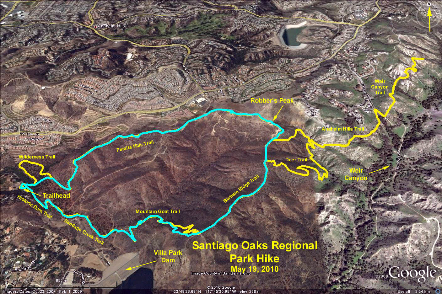
Hike Summary: Composite trail hike includes hiking in the canyon, then in the foothills, and back to the canyon. Varied views along the way include, at different points, the canyon, nearby hills and mountains, and upper scale housing areas.
Trail Head Directions: Get to the 55 Freeway (Costa Mesa Fwy) and exit east on Katella Ave. Note: From the beach cities, get on the 55 at the south end from any of these: PCH, the 405, the 73, or the 5, and go north to Katella. From the valley, if you take the 210/57/91 or the 101/5/91, take the 91 east to the 55, which is the north end, and go south to Katella. From the Katella Ave. exit, go east on Katella for 3.0 miles. (Katella's name changes along the way to Villa Park Rd and then Santiago Canyon Road.) Turn left on Windes (the right side is called Meads), which has a traffic light. Santiago Oaks Regional Park is 3/4 mile away with signs but go 1/4 mile to Oak Lane and turn right, bear left on Windes again in 1/4 more mile, and drive to gate. Pay $3 at the at the gate and drive 1/4 mi. to the parking area. Restrooms and a picnic area are nearby.
Hike options:
Basic Hike:Trails have been constructed to have almost no overlap, going through the park and surrounding hillsides. Trails in sequence are Historic Dam, Santiago Creek Trail (3/4 mi), then ascend on the Mountain Goat Trail (viewpoint on top), Barham Ridge Trail, in the hills along Deer Trail (and a bit of Anaheim Hills Trail), pass Robbers Peak, back down to the lower park area via oak Trail, then Peralta Hills trail to its end (4.5 mi total to this point). Then we walk Wilderness Trail, Santiago Creek, Towhee, Rinker, and a final loop on Bobcat Meadow (picnic area at 5.5 mi total), and return to the start via Santiago Creek Trail and the Historic Dam.
Shorter Hikes: Many excellent options exist to go on fewer of the trails I have pasted together and yet still be able to include the canyon park and hillsides areas. This will be obvious from the map I will distribute at the trailhead.
Longer hikes: Deer Trail/Anaheim Hills Trail connect to Anaheim Hills Trail and then Weir Canyon Trails which provide interconnection across these parks, with several miles of hiking. There are also other options within the park including a Yucca Ridge/Anaheim Hills/Coachwhip Loop and more.
Google Earth Photo - Santaigo Oaks Regional Park
GPS Data:
Cyan Track - RT = 4.0 mi.
Yellow Track - RT = 8.8 mi.
Trailhead elevation = 450 ft.
High Point @ Robber's Peak = 1134 ft.
Delta elevation = 684 ft.