Distance: Basic Hike: 6 miles RT or more; max. Elevation change = 1000 ft.
Rustic Canyon Option: 5 miles RT; max. elevation change = 1500 ft.
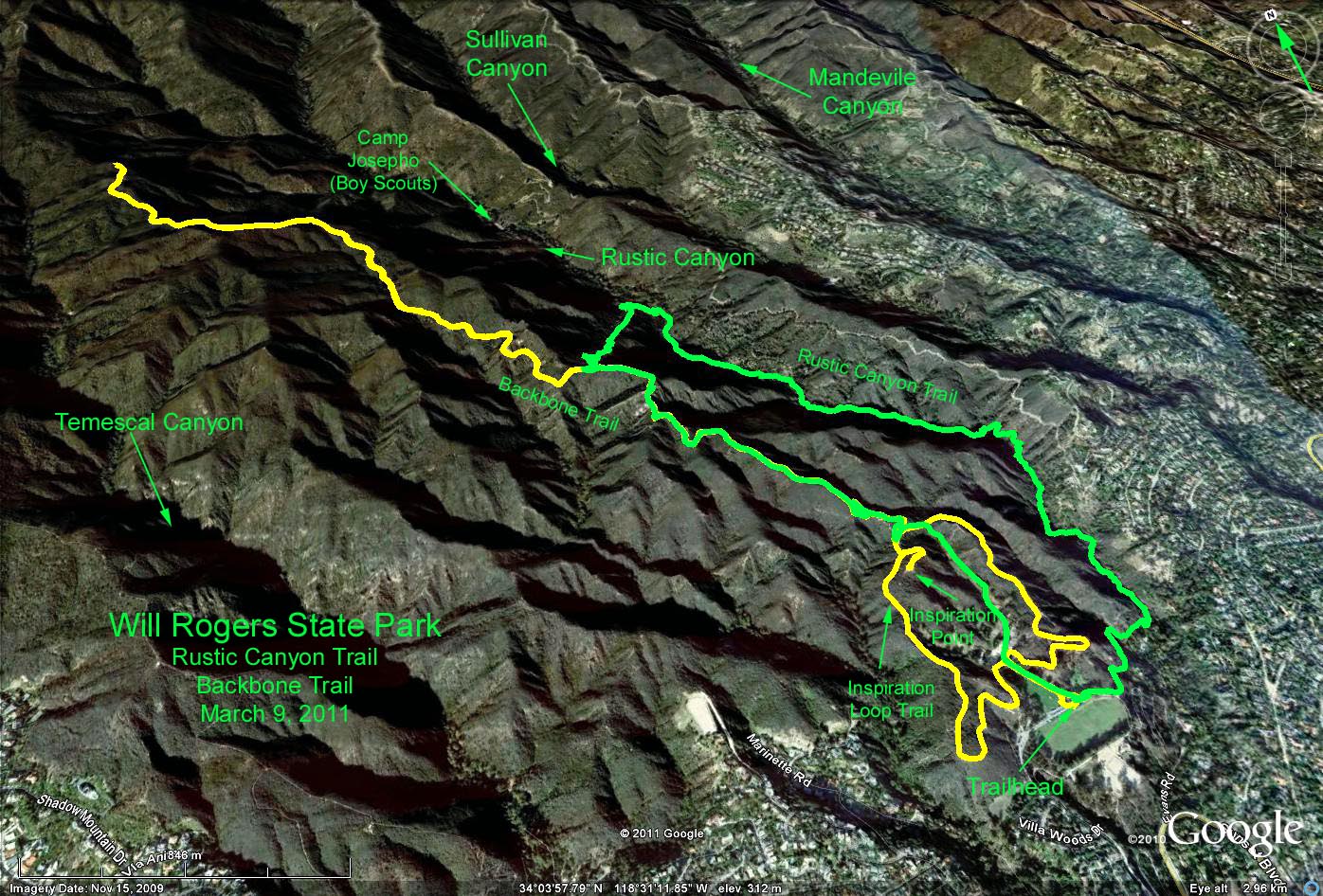
Summary: Basic hike climbs out of the park to the junction with the Backbone trail, then follows the Backbone as far as one wishes. The Rustic Canyon option follows the canyon floor until it junctions with the Backbone trail, then climbs the west ridge to regain the trailhead.
Directions to Trailhead: Valley folks can take Topanga Canyon Road to PCH, and then south to Sunset Blvd. About 3 miles up Sunset turn left on Will Rogers State Park Road. Alternately, take the 405 freeway to Sunset Blvd, go west about 7 miles, and then right on Will Rogers State Park Road.
Coming from the south, take PCH to Sunset Blvd. and follow instructions above. Note that there is a parking fee or you can use a pass from the California State Park Foundation.
The Hike: The basic hike starts from the picnic area up a service road to the Inspiration Loop Trail, turn left onto the trail to do the loop clockwise. Just north of Inspiration Point we will come upon a fork with the Backbone Trail. Turn left up the Backbone Trail and continue until your heart is content. A nice spot for lunch is a massive oak tree on the trail at about 1 mile beyond the Backbone junction. Return back down to Inspiration Loop Trail, turn left to complete the clockwise loop back to the picnic area.
Short hikers can continue clockwise on the Inspiration Loop Trail for a total of about 2 miles with about 300 ft. elevation gain.
Hikers choosing the Rustic Canyon option can walk eastward along the park parking lot until reaching the trail to the canyon floor. Once in the canyon, the trail is very narrow with a good likelihood of getting your boots wet if there is any water. Continue up-canyon until the Backbone connector trail crosses the stream. Turn left and follow the trail up the west ridge of Rustic Canyon (trail is rather steep with loose rocks) until it meets the Inspiration Loop trail. Turn left and return to the trailhead, or turn right and continue on the Backbone as far as you wish.
Google Earth photo - Will Rogers to Backbone Trail/Rustic Canyon Loop
GPS Data:
Basic Hike: (Yellow trace) RT=8.5 miles; max. elev. change = 950 ft.
Optional Hike: (Green trace) RT=5.1 miles; max. elev. change = 1475 ft.