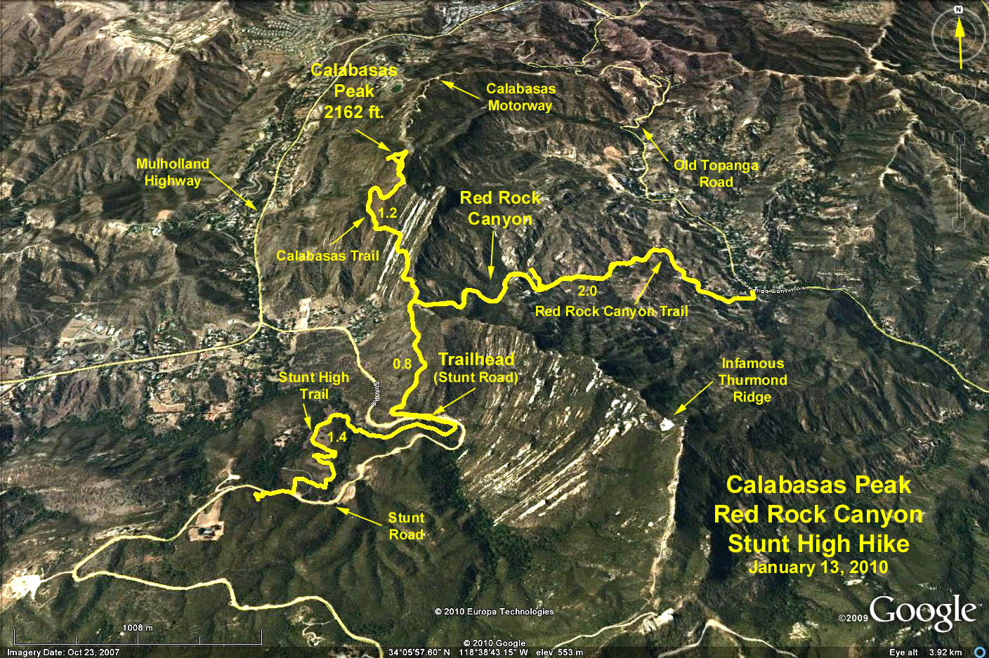
Summary: There are three hikes, all starting from the trailhead on Stunt Road: the Stunt High Trail, the Calabasas Peak Trail, and the Red Rock Canyon Trail.
Directions to Trailhead: 101 freeway west toward Ventura about 10 miles beyond the 405 freeway; exit at Valley Circle/Mulholland. Go left/south on Mulholland Drive. After about 1/4 mile, bear right onto Valmar Road (there is a light) which turns into Topanga Canyon Road. Continue ½ mile to the light and turn right onto Mulholland Highway. Continue on Mulholland for approximately 5.0 miles to Stunt Road at mileage marker 25.74. Turn left onto Stunt Road and go to just beyond mileage marker 1.0, (1 mile) and park in the parking area.
From the South Bay: Go north on PCH (SR-1) to Topanga Canyon Drive. North on Topanga Canyon Drive to Mulholland Highway. Left on Mulholland Highway to Stunt Road. Continue as above. There is a portable toilet at the parking lot.
The Hike: The Stunt High Trail is a back and forth 2.5 mile round trip hike that starts at the parking lot, heads west ½ mile through a lovely wooded canyon. At 0.55 miles, there is a blank trail marker where you turn left to go up hill for ¾ of a mile. You cross one back road and the hike ends at the next road crossing which is Stunt Road at about 1,700 feet. You can go back the way you came or carefully proceed left down the road to return to the parking lot.
Red Rock Canyon Trail is a back and forth 3.8 round trip hike that starts across the street from the parking lot. Proceed uphill to a junction at .7 miles/1450 feet where the road continues uphill to Calabasas Peak (see next hike) but also forks to the right to Red Rock Canyon. Follow the right fork for an additional 1.2 miles as you descend into Red Rock Canyon to a low point of 1,000 feet at Old Topanga Canyon Road. There is water at 1.7 miles and picnic tables at 1.9 miles. Return by the same path to the Calabasas Peak Trail or back to the parking lot.
The Calabasas Peak Trail starts at the junction with the Red Rock Canyon Trail 0.7 miles from the parking lot. It is a 2 mile roundtrip to the peak at 2162 feet and features a panorama view of the entire area.
Google Earth Photo - Calabasas Peak, Red Rock Canyon & Stunt High Trail from Stunt Road Trailhead
GPS Data:
Stunt High Trail: RT = 2.8 mi., elevation gain = 530 ft.
Red Rock Canyon: RT = 5.6 mi., elevation loss (junction to Old Topanga) = 560 ft.
Calabasas Peak: Adds 2.4 mi. RT, elevation gain (juncton to peak) = 620 ft.
NOTE: Elevation of Trailhead = 1260 ft., and junction of Calabasas Peak & Red Rock Canyon = 1545 ft.