Directions to trailhead:
From San Fernando Valley: Take 101 E to the 5. Go south on the 5 to the 60. Go east on the 60 to the 57. Go south on the 57 to Imperial Highway. Go west (right) approximately 0.5 mi to State College Blvd. Turn left (south) to Bastanchury. There is ample parking in a parking lot just east of the Summit House restaurant on the SW corner of Bastanchury and State College.
From the South Bay go east on the 91 to State College Blvd in Fullerton. Turn left (north) to Bastanchury. Park in the parking lot as described above.
There are two hike options:
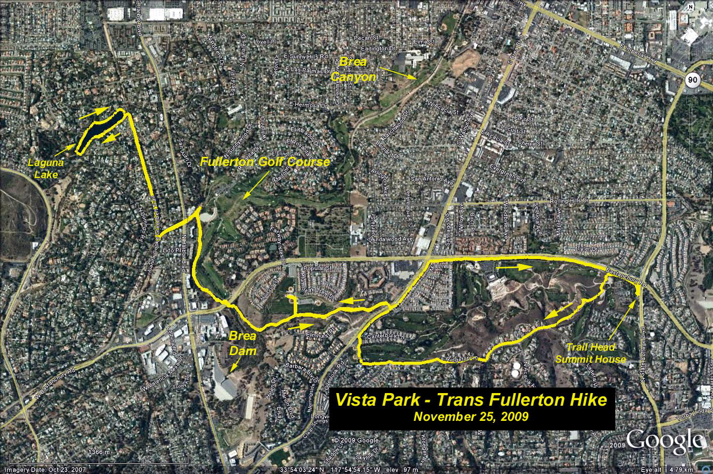
1) 3.1 mi round trip. Take the Panorama Trail behind the Summit House southwest about 0.5 mi to Ladera Vista Dr. Continue west to Skyline Dr. Go west on Skyline Dr. to Ridgetop Lane. Continue west to Brea Blvd. Go north on Brea Blvd on the dirt trail next to a white fence about 0.5mi.to Bastanchury. Continue east about 1 mi. back to State College.
2) 9 mi round trip: At the junction of the Panorama Trail with Brea Blvd go 0.25 mi north to Ashburn Terrace. Cross Brea Blvd. The Lost Trail continues west along the white fence about 1 mi. You go through a double culvert under Bastanchury and the Brea Dam Trail continues parallel to the Fullerton Golf Course for about 0.75 mi to a junction with the Union Pacific right-of-way. Turn left and go about 0.1 mi. along the right-of-way under two overpasses to the junction with the Juanita Cook Greenbelt just up a little hill. Go right here for about 0.75 mi. until you reach Laguna Lake. Go west and all the way around the lake enjoying the many waterfowl, some resident permanently and some migratory. The lake was recently dredged by the city and is clear as a bell. Don't feed the waterfowl. Return the way you came.
Elevation gains negligible.
Restrooms: There is a portapotty at the east end of Laguna Lake and a luxury restroom at the west end. There are also luxury restrooms at the Tennis Center behind St. Jude Hospital, which are reached by going left uphill from the main trail a short distance before reaching the culverts. Those of you who are taking the short hike and feel the call will have to use the Carl's Jr. at Brea and Bastanchury
Refreshments: Walk across Bastanchury to Mountain View Park on the NW corner.
Google Earth Photo - Trans Fullerton Hike
GPS Data:
RT = 9.2 mi.
Trailhead elev. = 425 ft.
Max elev. change = 330 ft.