Distance: About 7-8 miles
Elevation gain: About 800 ft.
Overall Description: Pleasant, hike starting across from the ocean and Pacific Coast Highway and headed inland up into the foothills on a good path (used also by mountain bikers and forest service vehicles). The baseline hike is a loop, with uphill walking along the ridge area to the turnaround point and downhill through El Moro Canyon on return. The ranger did say that if it rains, the trails are closed the day of the rain and for up to 48 hours afterward. Also the trails close during any fire red flag status conditions declared by the Orange County Fire Authority.
Directions to the Trailhead: Our hike is at the southern end of Newport Beach, north of Laguna Beach.
From the PV area, take the 405 south and then the 73 Freeway south where it breaks off from the 405 in the Costa Mesa/Irvine/Newport Beach area.
From the Valley, if you take the 101 south, take it to the 5 freeway south (either through the city or via the 134). Take the 5 south until the 55 Freeway south (the Costa Mesa/Newport Freeway). Take the 55 south until the 73 south (after passing the 405 exit).
For all of you at this point, exit the 73 at the Macarthur Blvd. exit heading south. Take Macarthur (for just about 3 miles) until it ends at the Pacific Coast Highway (Route 1). Turn left (south) and proceed for 4.1 miles until a traffic light for the El Morro School/Crystal Cove Visitor Center turnoff. You'll pass Poppy Street, Newport Coast Drive, and various Crystal Cove signs along the way. (There are many other Crystal Cove State Park sites on this drive). Just prior to this traffic light you'll see a brown sign on the right saying El Moro Canyon. This light is also for an elementary school. Turn sharp left at the light. You'll pass the school and stop at a stop sign immediately thereafter. Turn right, and then turn right again before a metal gate and into the Visitor Center parking lot. This whole little drive from the traffic light is about 0.3 miles. Pay your parking fee and you'll be all set.
Parking and Restrooms: There's a good size parking lot by the Ranger Station/Center. Parking fees are $10/vehicle so car-pooling would save funds. Restroom facilities are available at the Ranger Station. Only one small portable toilet unit was visible along my scouting hike (at Deer Creek Campground), so don't count on facilities along the main hiking paths.
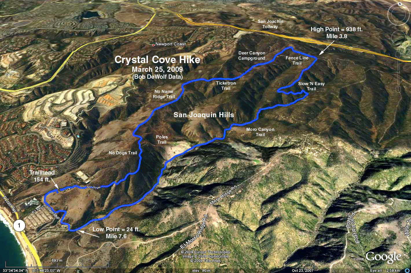
The Baseline Hike: From the Visitor Center/Ranger Station entry door, turn right and proceed up to a closed yellow metal gate on the right side. This is the trailhead. We follow the "No Name Ridge" Trail (which includes, in order, "No Dogs Road", left on "Poles Road", right (east) on "No Name Ridge Road", continue on "Ticketron", and continue left on "Deer Canyon Trail." Along the way, we pass the "West Cut Across" trail (at 1.3 miles from the trailhead) which some of you could use to descend steeply to the Moro Canyon trail for a shorter hike.
As we continue on the Deer Canyon Trail, we pass the Deer Canyon Campground (3.0 miles from the trailhead) which has two picnic tables and a single port-a-potty. After 0.5 miles we see the gate to a paved road (the San Joaquin Toll Road) just outside the park boundary. Just prior to this gate, turn right onto the "Fence Line" Trail. Hike for about 0.5 miles until we turn right at "Slow N' Easy" Road. (The rabbits could choose to continue on Fence Line until Missing Link Trail and then Moro Ridge Trail which ultimately ends at El Moro Canyon Trail, our trail back to the trailhead).
We continue on the "Slow N' Easy" Trail for about 1.0 - 1.2 miles until we reach the El Moro Canyon Trail, onto which we make a sharp right turn. Make sure you turn on the El Moro Canyon Trail - there is a "You are Here" sign at this intersection, and there are other intersections prior to this point where mistakes can be made. We take the El Moro Canyon Trail until we return to the Ranger Station in about 2.6 - 2.9 miles, passing the Poles Road junction in 1.2 - 1.5 miles, and some closed trailer parks and the school area at 1.4 miles.
There are excellent trail signs with maps and "You are Here" markers throughout the park.
Refreshments will be at a group of picnic tables above the restroom facility to the right of the Ranger Station.
Google Earth Photo - Crystal Cove State Park
Crystal Cove State Park Trails
GPS Data:
RT = 8.2 mi.
Trailhead = 154 ft.
Low Point = 24 ft.
Max Elevation Change = 914 ft.
2017-09-06