Distance: 6 miles RT
Elevation gain: 1700 ft.
Directions to Trailhead: From the Foothill Freeway (210) exit at Sierra Madre Blvd./Altadena Dr. (driving eastbound) and if driving westbound on the 210, exit at San Gabriel Blvd/San Marino. Turn north on Altadena Dr. and follow it about 1.5 miles. Just beyond New York Dr., enter Eaton Canyon Nature Area Park on the right. Park at the far end of the parking lot just beyond the nature center.
The Hike: The hike to Henninger Flat starts on a steep trail leading out of the parking lot. This trail eventually meets the fire road (Mt. Wilson Toll Road) which continues up and beyond Henninger Flat. There are nice views of the LA area if the visibility is good. Henninger Flat is a pleasant campground with massive pine trees sheltering the picnic tables. There is a great museum with the flora and fauna of the area displayed, and if there is time, ask to see the video on the Echo Mountain facilities in their hey-day including the cogwheel tram up Rubio Canyon, the Mt. Lowe railway, the Echo Mountain House, power station, etc.
For people preferring longer options, continue on the toll road as far as you want toward Mt. Wilson. Alternatively, explore the trails and roads that lead off the toll road to the helicopter pad and to the upper and middle campgrounds. A hike to the flat and the falls can be combined by using the toll road instead of the trail on the downward leg.
For those preferring a shorter hike, the Eaton Canyon Trail to Eaton Canyon falls is a pleasant hike. There is only about 430 ft. of elevation gain with a round trip to the falls of 4 miles. Hiking the last 0.6 miles to the falls is a little more rugged with numerous stream crossing and lots of rock hopping.
We will have refreshments just beyond the parking lot where there are picnic tables. Andy Gumps are available near the picnic tables.
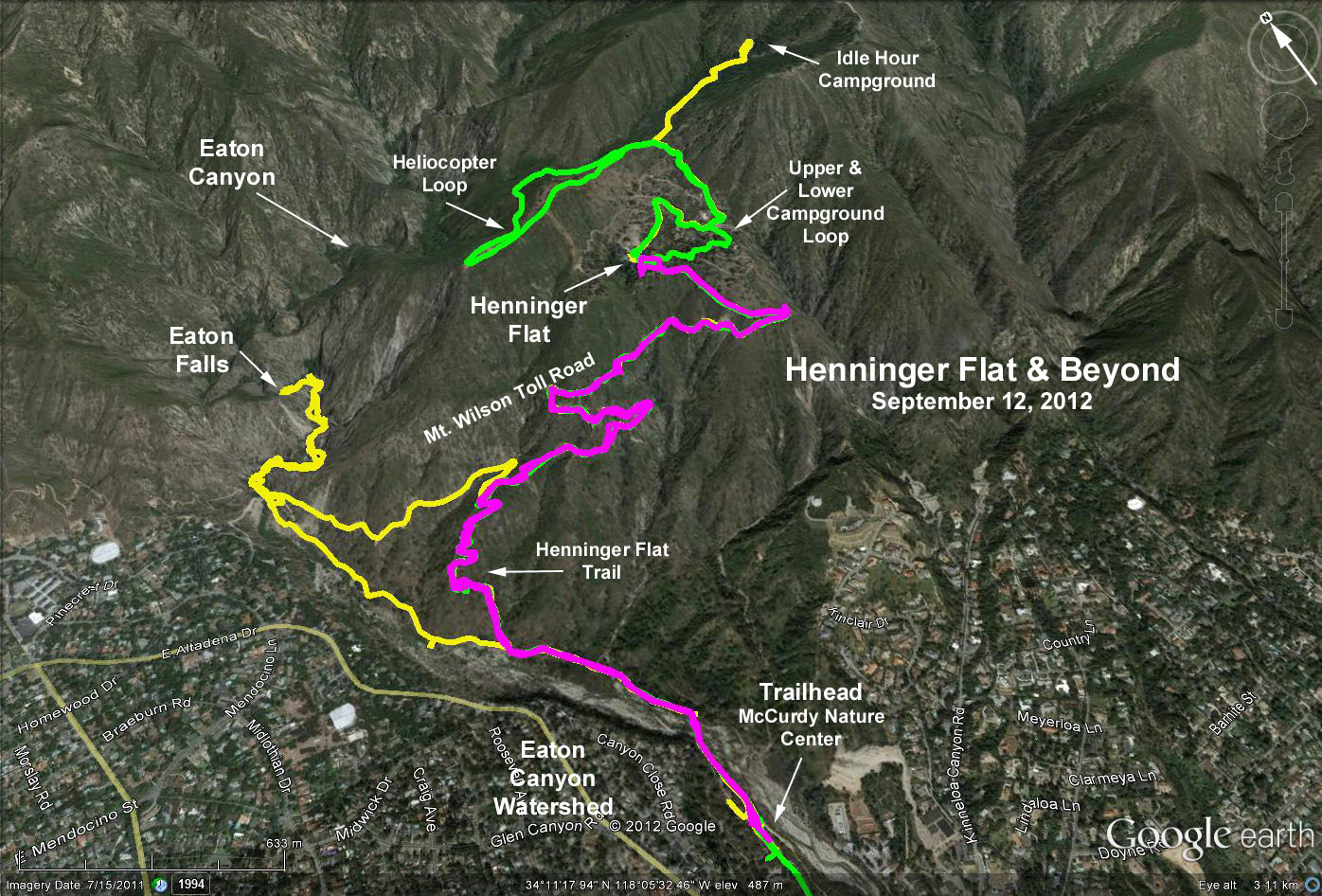
Google Earth Photo - Henninger Flat Hikes
GPS Data:
Basic Hike (magenta trace): RT = 6.1 mi.; max elevation change = 1675 ft.
Flat-Extended Trail - Falls Combination (yellow trace): RT = 10.8 mi; max. elevation change = 2150 ft.
Flat-Helicopter Pad-Upper and Middle Campgrounds (green trace): RT = 8.7 mi.; max. elevation change = 1900 ft.