Distance: 6.2 mi. RT.
Elevation gain = 500 ft.
Directions to Trailhead: Turn north off of PCH on Bonsall Dr. approximately 0.9 miles west of Kanan-Dume Road. Continue north on Bonsall for about a mile until it ends in a dirt parking lot. The rest rooms are south of the parking area and trailhead. Note to drivers returning to PCH: Bonsall Dr. has no eastward access onto PCH; you must take the small connector road, Rainsford Place, and come out via the stop light on Busch Dr.
The Hike: The basic hike is a combination of essentially all of the well marked trails in the lower part of Zuma Canyon. A short access trail leads to the Ocean View Trail which climbs to the east ridge above Zuma Canyon. Its a moderate grade and represents the majority of the basic hike's elevation gain.
After first attaining the lower portion of the ridge, a sign is encountered, and we have our first good panoramic view of Point Dume, which is due south. A couple of hundred yards further brings us to a second sign at the junction of the Canyon View Trail and the Kanan-Edison (fire) Road. Rabbits should continue up (and back) the overgrown fire road for a distance and time to their liking. For the record the Zuma Canyon connector trail is 1.3 miles past the junction.
A couple of hundred yards past the junction on the Canyon View Trail gets us to a small ridge and the hikes apex. Continuing on the trail returns us to the canyon floor and with a right turn, the Scenic Trail gets us deeper into the canyon. The northward traveling Zuma Canyon Trail disappears about 0.7 miles past the last junction and modest boulder hopping of a couple of hundred yards gets us to a small dam.
Return back down the canyon and turn right onto the Zuma Loop Trail. The optional higher ground mini-loop is recommended. Continuing down the trail we pass the cutoff to the Busch Drive trail head, and return back to our trailhead.
Refreshments served in the shade of the trees, just south of the parking lot.
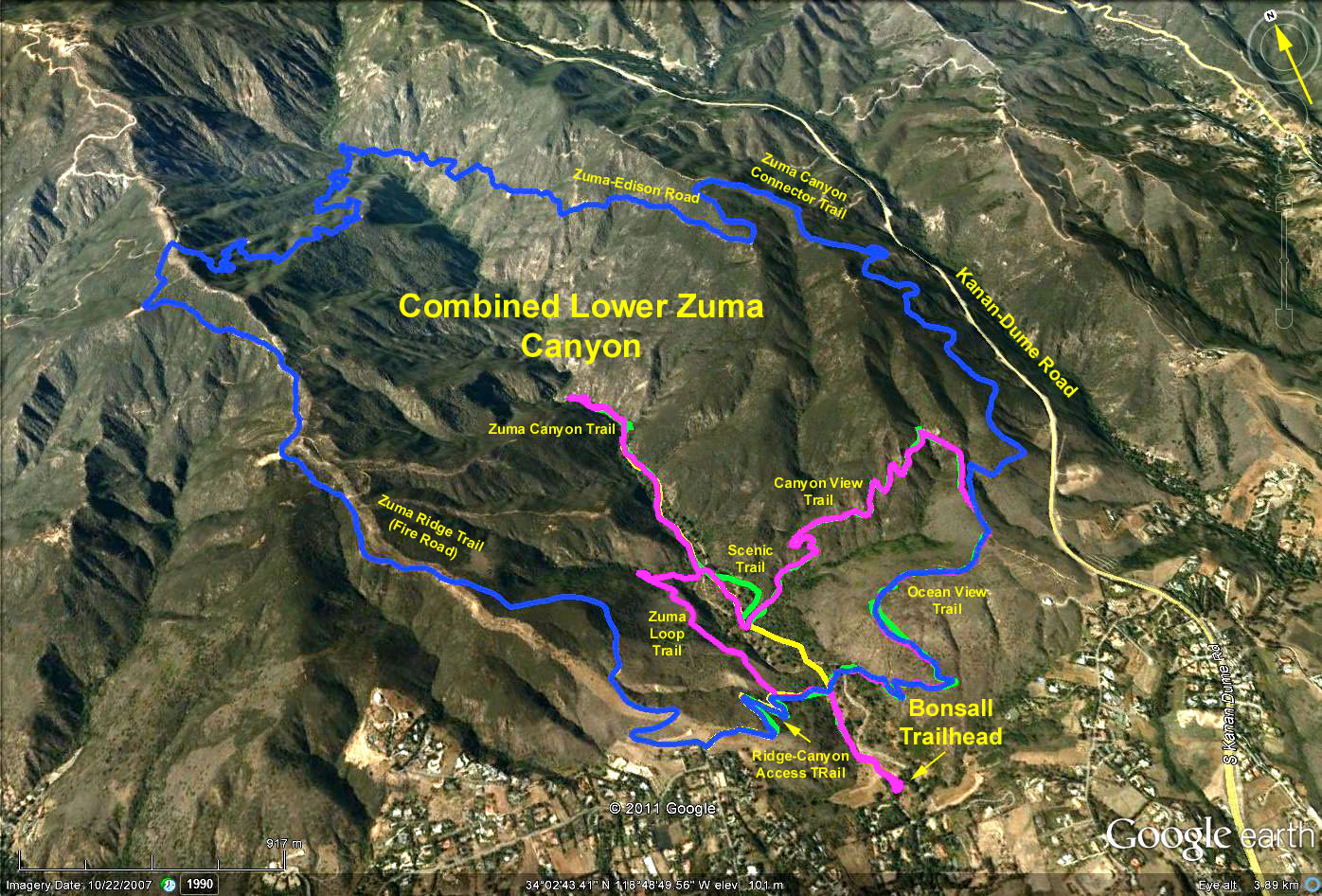
Google Earth photo - Lower Zuma Canyon
GPS Data:
Blue Trace = 10.6 miles RT with cum elevation gain = 2700 ft.
Yellow/Green Trace = Ocean View + Canyon View + Zuma Canyon + Scenic Trail (but not Zuma Loop Trail)=5.8 miles RT with cum elevation gain = 800 ft.
Magenta Trace = data taken 7/30/2008 which added the Zuma Loop Trail = 6.5 miles RT with cum elevation gain=1000 ft.