Distance: 7 miles RT
Elevation Gain = negligible
Directions to Trailhead: From the South 405 or from the South 55 (Newport/Costa Mesa Freeway), turn onto the South 73 (Corona del Mar Freeway) until (shortly) the Campus/Irvine Ave. exit. Get off here, moving immediately into the right lane to turn right (south) on Irvine Ave. Turn left shortly at University Drive and make the first right into the (dirt) parking lot area. There is no parking fee and no permit is required at this parking area. Well meet there; its a very short walk to the Muth Interpretive Center (which is nice to visit when were done). If youre in the area, you can turn south from Bristol onto Irvine Ave.
The Hike: This hike is along about 30% of the perimeter around Upper Newport Bay in Newport Beach. The primary pathway is a joint hiking and bicycle trail in a pleasant environment for the summer. The hike begins at the Peter Muth Interpretative Center at 2301 University Drive on the west side of the Bay and ends at a kiosk and overlook area at Big Canyon on the east side of the Bay.
The basic trail is along a paved bike path, although many parallel dirt trails exist along the first mile. The trail then comes to Jamboree Road where the official trail/bikeway is along the wide sidewalk for a while, crosses a bridge over the bay. The path then turns right at Eastbluff Drive and then Back Bay Drive. The suggested turnaround point at Big Canyon is a kiosk area which has about five portable potties with hand cleaner napkins. Note that this is the only restroom-type facility after the one at the start at the Muth Interpretive Center. I presume that at the point we go to Jamboree Road, one could go to a nearby bank or business to find a restroom if necessary.
Hikers wishing a shorter hike can turn around at any point. Hikers wanting a longer hike can go past the Big Canyon kiosk area and go either ½ mile and back on a trail at Big Canyon or continue further along the main hike for a similar distance to San Joaquin Road. Also, for all hikers, a nice trail at the starting point (Muth Interpretive Center) to the ocean side of the bay provides an additional approximately one mile pleasant walk.
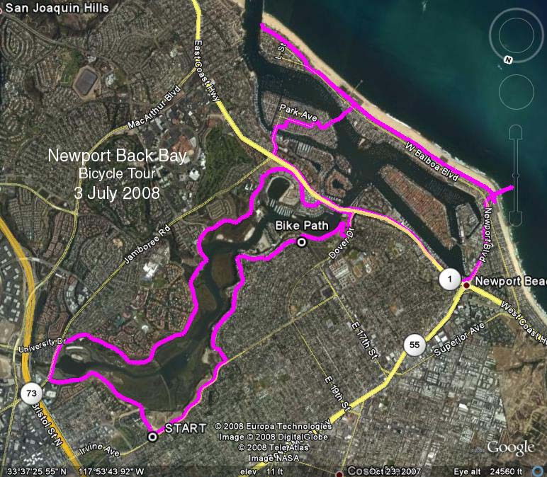
For those bikers in our group who wish to do so, one could bike around the full circumference of the Bay, for about a 19.5 mile circle in 3 or less hours. This would include a segment along Pacific Coast Highway. We will arrange for bike rider leaders for any of us who wish to do this.
Note: Depending on the docent, there is a chance we may need to go to a nearby park on Eastbluff to consume our refreshments at the end of our hike. Im assuming at this point that this will not be necessary.
Google Earth Photo - Upper Newport Bay
GPS Data:
RT = 20.6 mi. (bike ride)
Trailhead = 60 ft.
Max Elevation Change = 46 ft.