Distance: 6 miles
Elevation Gain: ~nil feet
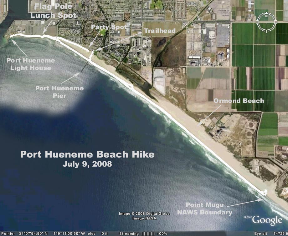
Directions to Trailhead: From the Valley - Take 101 toward Oxnard, exit Las Posas Road south to Hueneme Road. Turn right approximately 7 miles to Ventura Road. Turn left on Ventura Road (there is a sign for Port Hueneme Beach Park on the far left corner). From points south, exit PCH at Port Hueneme Road. Go west 5 miles to the park entrance (look for the sign). Turn right into parking lot (keep lunch counter on your left.). Parking is $5 from a vending machine. It is recommended that you use a $5 dollar bill. Restrooms are available.
The Hike: The hike (or walk) will begin from the parking lot at Port Hueneme Beach Park. Walk along the ocean to Point Mugu Naval Air Station (NAS) boundary and return. Note that a half mile short of Point Mugu NAS is a channel from the power plant which crosses the beach to the ocean. Depending upon out flow from the power plant and the tide this channel may not be fordable, thus reducing the round trip distance by 1 mile. Elevation gain is nil unless you climb some dunes.
An optional walk along a paved path from the west end of the parking lot is to the entrance of the civilian side of Port Hueneme itself and an old light house which is sometimes open to the public. Round trip is a little more than a mile. Elevation gain is nil; no sand dunes.
Optional sites to visit: A highlight for bird watchers are two wetland preserves, one at the end of the walk at Point Mugu NAS, and the other which is not accessinle from the beach. Both sites are accessible by car.
1. The site at Point Mugu NAS features the habitat for dozens of bird species including Least Tern, Western Snowy Plover (nesting areas protected behind orange fencing) and Brown Pelican. To reach this site by car, take Arnold Road south from Hueneme Road 3 miles east of the Port Hueneme Beach Park, and drive south 3 miles.
2. The other site is 1/2 mile south of Hueneme Road on Perkins Road (1/2 mile east of the entrance to Port Hueneme Beach Park) to the parking lot. A short loop walk will take you onto the wet lands.
3. If you are not in a hurry to get home, drive north on Ventura Road to the third traffic light (approximately 2 miles) turn left on Sunkist. This is the entrance to the Seabees' base with a great museum of the Seabees/ history. Go to "Pass & ID" (on your right, well marked) and get a pass. Drivers license required for ID. Be sure to ask for directions for parking as you cannot drive in but must walk. The museum is a short distance inside the gate.
Google Earth Photo - Google Earth photo - Port Hueneme to Point Mugu
GPS Data:
RT = 6.9 mi. NAS boundary to lighthouse
Elevation gain 25 ft.