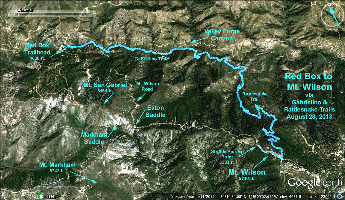
Red Box to Mt. Wilson via the Gabrielino and Rattlesnake Trails
GPS Data:
Main Hike Distance = 8.1 mi. one way
Elevations: Trailhead = 4630 ft.; Low point Gabrielino Trail = 3616 ft.
High point Mt. Wilson = 5618 ft.
Directions to the Trailhead: Drive to Red Box (mileage paddle 38.38, 14 miles from 210 fwy. / Hwy 2 junction). We will have to arrange to leave vehicles up at Mt. Wilson for those doing the whole hike.
The Hike: This is a shuttle hike, the intent is to go one way. Starting from Red Box, the main hike goes east on the Gabrielino Trail along the West Fork of the San Gabriel River. After approx. 2.3 miles and a drop of approx. 1000 ft. we will reach a turn-off on the left to Valley Forge Campground. At this point there are four options:
Option 1: Take the turn-off on the left to the campground. At this point you can rest, eat an early lunch, etc. and then return to Red Box the way you came.
Option 2: Just past the left turnoff to Valley Forge Campground, you can turn right onto the Valley Forge Trail up Falls Canyon to Eaton Saddle (a distance of 2.7 miles and a climb of approx. 1500 ft.). We can probably coordinate transportation back from Eaton Saddle with the transportation back from Mt. Wilson.
Option 3: The main hike continues on the Gabrielino Trail another 1.5 miles past the Valley Forge Campground trail intersection until we reach the Rattlesnake Trail turnoff on our right. We then go 3.2 miles and 2100 ft. up to Mt. Wilson on a mostly shady trail.
Option 4: Ride up to Eaton Saddle or Mt. Wilson with the shuttle vehicles, and hike OPTION 2 or 3 in reverse.
Refreshments will be served at Red Box.