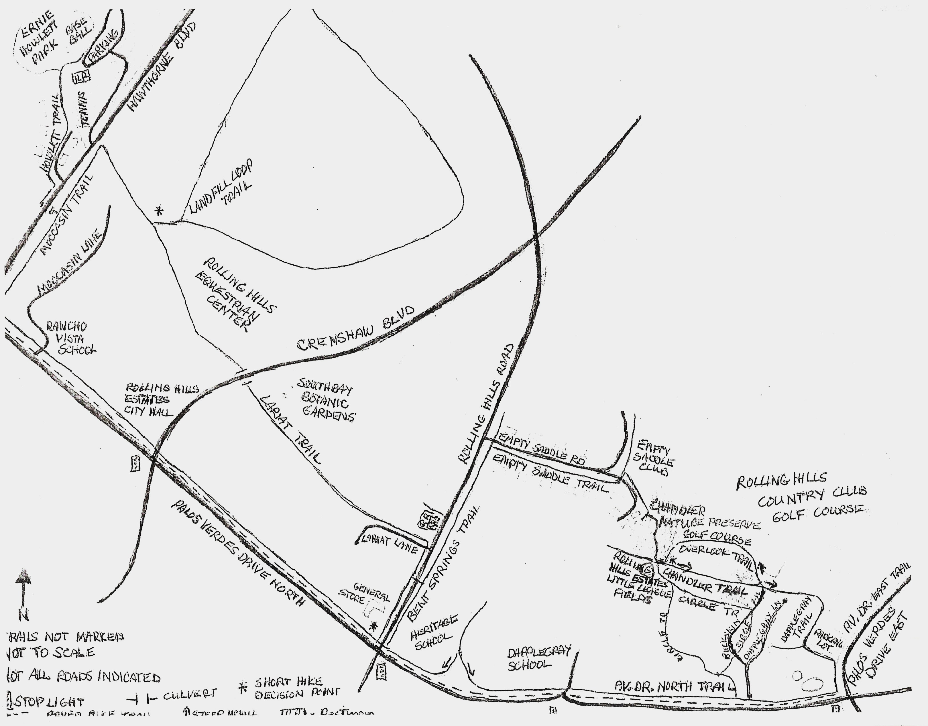
Directions to Trailhead: The trailhead is at Ernie Hewlett Park. Entrance is on Hawthorne Blvd. 1.1 miles south of Pacific Highway at a relatively blind driveway to the right (west) with signage both in the median and on the right. Park at the left end of the lot; restrooms in adjacent building near tennis courts. Lunch will be at the General Store, which makes great sandwiches. The trails listed in the hike are NOT marked, so pay attention to the directions.
The Hike: Proceed south (left) on the Hewlett Trail (near the baseball field) which then zigzags east/south along the tennis area, between houses and down to a culvert under Hawthorne Blvd. After going through the culvert, turn left (north) on the Moccasin Trail and follow it to the Landfill Loop Trail* which is another left turn. Walk the perimeter of the landfill clockwise bearing right whenever possible, and observing all No Trespassing signs. Exit back onto the Moccasin Trail at the entrance gate and turn left (east) along the Rolling Hills Equestrian Center, cross under Crenshaw Blvd. via the culvert and continue on the Lariat Trail along the South Coast Botanic Garden to Rolling Hills Road.
Restrooms are available to the left inside the back gate to the Botanic Garden if needed, otherwise turn right (south) to the crosswalk, cross Rolling Hills Road and proceed left (north) on Bent Springs Trail, then right (east) on Empty Saddle Trail, crossing Empty Saddle Road and along the Empty Saddle Club, then into the Chandler Nature Preserve on the Chandler Trail. Continue uphill at the first Y-intersection and turn hard left (north) onto the Golf Course Overlook Trail* at the second Y.
After re-merging the Chandler Trail, continue down then up a steep hill before proceeding between houses. Turn right (south) onto Dapple Gray Trail and walk along the Rolling Hills Golf Course before turning left (east) araound a parking lot to meet the Palos Verdes Drive East Trail where you turn right (south)., At the signal turn right (west) onto the Palos Verdes Drive North Trail and continue to the General Store for lunch. After lunch proceed north on Rolling Hills Road to the Lariat Trail, turn left (west) and retrace your way to Ernie Hewlett Park (skipping the Landfill Loop) for refreshments. Returning via the Palos Verdes Drive North trail (which is quite hilly), or by the bike path (which is flatter), is slightly shorter than retracing the morning hike
*For shorter hikes eliminate the Landfill Loop (approx. 7.4 mi. RT), and Golf Course Overlook (approx 6.5 mi. RT).
Rolling Hills Estates Horse Trails Map
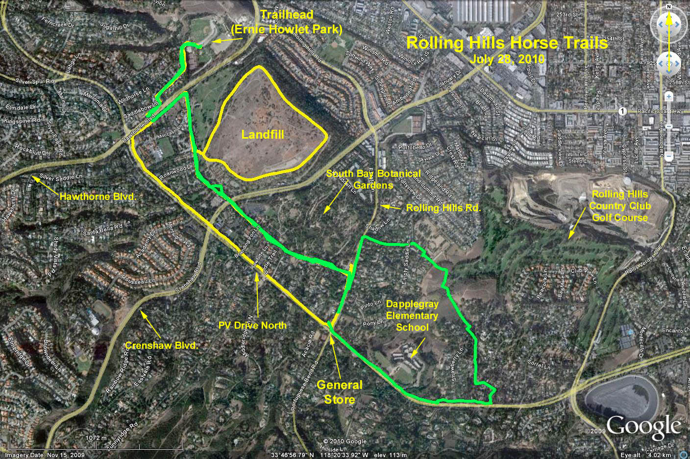
Google Earth photo - Rolling Hills Horse Trails
GPS Data:
Yellow trace = 5.4 mi. RT. Landfill loop = 1.5 mi.
Green trace = 5.9 mi. RT. Golf Course Overlook = 1.5 mi.
Green trace + Landfill loop + Golf Course Overlook = 8.9 mi. RT. Elevation Gain = 150 ft.
NOTE: The green trace does not show the full hike since it uses the Circle Trail to avoid the eastern portion along the Rolling Hills Golf Course.