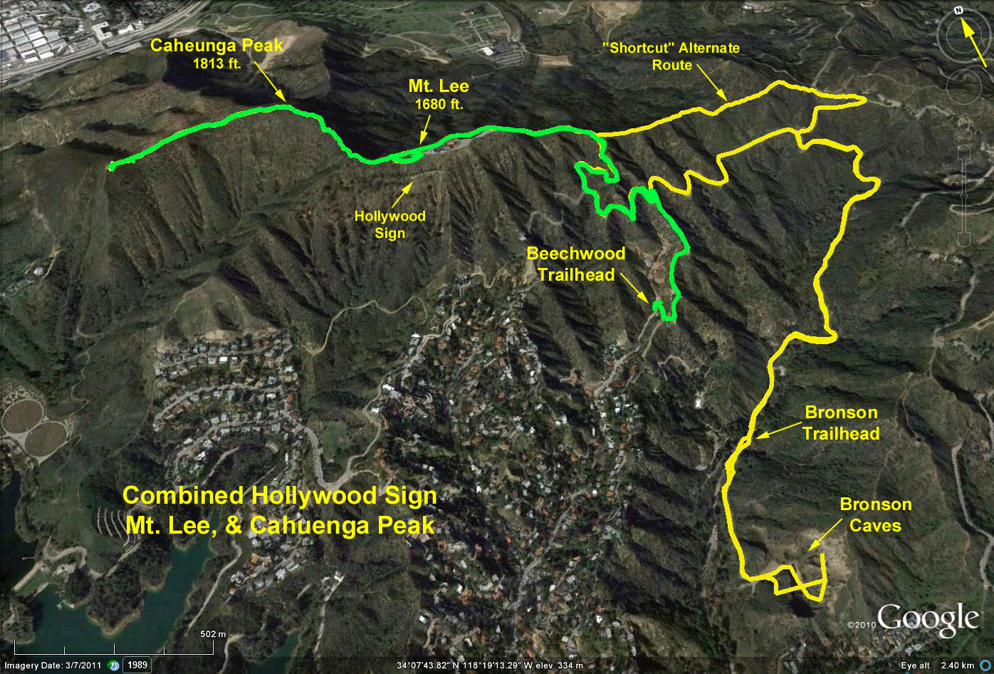
Distance: Basic Hike To Mt. Lee (Sign) from Bronson Ave. = 6 mi. RT, max. elev. change= 1000 ft.
Alternate Trailhead to Mt. Lee from Beechwood Dr. = 3.5 mi. RT, max. elev. change = 700 ft.
Cahuenga Peak add-on from Mt. Lee: .7 mi. RT, 140 ft. elev. change.
Bronson Caves add-on from Bronson Trailhead: 0.9 mi RT.
History: To make sure that everyone knew about their new real estate development, a group of investors, including Los Angeles Times publisher Harry Chandler, ordered a huge wooden sign built atop Mt. Lee. The sign read: "HOLLYWOODLAND." The Beachwood Canyon Development was advertised as "above the traffic, congestion, smoke, fog and poisonous gas fumes of the lowlands." Looking back now, it's hard to believe Angelenos were worried about pollution in the early 1920s.
The letters, particularly the "H," frequently blew down and, in 1923, a depressed actress leaped from the sign. During a 1949 gale, the "LAND" part of the sign blew off. Finally, in 1978, celebrities, among them rock star Alice Cooper, Hugh Hefner and Gene Autry pledged $27,777.77. per letter to restore the HOLLYWOOD sign, sans LAND, to its former glory. Besides the sign, 1,640-foot Mt. Lee has another claim to fame: L.A.'s first television signals were broadcast from the peak in the 1940s.
The Bronson Caves were originally a quarry, the crushed rock from the caves used to pave the streets of a growing Hollywood. The many western and science fiction movies that were shot from the caves included Star Trek, Mission Impossible, Gunsmoke, Bonanza, and Batman & Robin.
Directions to Bronson Trailhead: From the Valley, exit US 101 (Hollywood Freeway) at Vine St. Bypass Vine St. and go east on Franklin Ave. to Canyon Drive and turn left. Continue 1.5 miles past Bronson Park to the end of the road. Park in the lot on the left.
From the south: Exit US 101 at Gower St., turn right up to Franklin Ave. and turn right. Continue east about .2 mile to Canyon Drive and turn left. Continue as per above.
Directions to alternate Beechwood trailhead: From the Valley, repeat above instructions proceeding east on Franklin except turn left on Beechwood Dr. (1 block east of Gower St.) and continue doggedly up Beachwood Drive past where the housing stops, to a parking area facing a cliff on your right and park (if you go to the stables, you've gone too far).
From the south: Exit US 101 at Gower St. Before you get to Gower St., turn right onto Beachwood Dr., cross Franklin and continue as per above.
The Basic Hike: The trail climbs up the canyon ultimately reaching an unsigned junction with the Mulholland Trail. Turn left on the fire road and wind west to an intersection with Mt. Lee Drive. Turn right and follow Mt. Lee Dr. up and around the peak to a chain link fence preventing you from standing on the actual summit of Mt. Lee (1680 ft.). The vistas here include all of Los Angeles (assuming it is clear), and the top of the Hollywood sign letters.
Optional Add-on: To hike out to Cahuenga peak and further beyond along the ridge, re-trace your steps to the point where Mt. Lee Dr. makes a sharp turn to the right. Look to your left to find a use-trail that leads further westerly toward Cahuenga Peak. Access to this trail is usually gained at the end of a chain link fence. The trail is rough and steep in places, but a steep final climb brings you to Cahuenga Peak, the high point of the Hollywood Hills at 1813 ft.
Alternate Hike: The trail follows a ridge just east of the stables. Your views of the Hollywood Sign begin almost immediately. Off to the right is the dome of the Griffith Park Observatory. Ignore the bridle path on your left coming up from the stables, and continue your ascent to an unsigned junction with the Mulholland Trail. Turn left, and proceed as above.
Be sure to walk down to (from the Canyon Dr. trailhead) and explore the Bronson Caves. This can be done either before or after the hike.
Google Earth photo - Hollywood Sign, Mt. Lee & Cahuenga Peak
Original 2006-04-19 Hike 799 Description
GPS Data:
Basic Hike: 5.8 mi. RT; max. elev. = 1030 ft.
"Short-cut" alternate path saves 0.3 mi. one way.
Alternate Hike: 3.4 mi. RT; max. elev. = 720 ft.
Add-on Mt. Lee to Cahuenga Peak: 0.6 mi RT; added elev. = 130 ft.
Add-on Mt. Lee to end of ridge: 1.4 mi. RT; added elev. = 130 ft.
Side trip to Bronson Caves: 0.9 mi RT, 100 ft. descent
2017-07-08