Distance: 9.5 mi RT
Elevation gain: 950 ft.
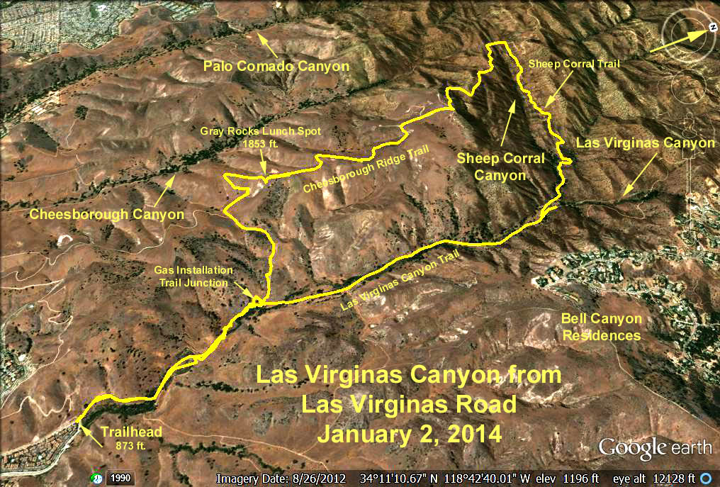
Directions to Trailhead: The trailhead is at the end of Las Virginas Road - about 1 mile north of the Las Virginas - Malibu Canyon exit off the 101. There is no restroom at the trailhead.
The hike: (Cum mileage in parenthesis) The trail rises along the west canyon hillside climbing a couple of hundred feet to a trail intersection just before reaching a fenced gas equipment installation (1 mi). Take the right hand trail which drops to the road in the canyon bottom and follow the road north along the canyon. After traversing the canyon floor, look for a trail leading off to the left where the road starts climbing out of the canyon toward the Bell Canyon Tract on the north and east (2.5 mi). Returning to the trailhead the way we came at this point would be one option yielding a round trip hike of 7 mi.
We leave the canyon road at this point and continue hiking westerly on the Sheep Corral Trail. The trail is an old ranch road that follows the northern slope of Sheep Corral Canyon, is steep and rutted in places, and eventually climbs up to the Upper Cheesborough Ridge Road (4.5 mi). We turn to our left and proceed south on this familiar road (we have been on this road before from our Cheesborough Canyon hikes) following it up to the gray rocks - our lunch spot summit (5.5 mi) where there is a view of the Sheep Corral Valley, with Rocketdyne in the background.
We continue south, after lunch, descending on the upper Cheeseboro Ridge Road. We bypass the de Anza trail coming in on the right and contine through a gate on the trail that drops back down into Las Virgenas Canyon and the gas installation trail intersection we passed before (8.5 mi). We turn right and follow the road back to the trailhead (9.5 mi).
Google Earth Photo - Las Virginas Canyon from Las Virginas Road
Refreshments at the trailhead.
GPS Data:
Shorter Option: 7 mi RT, max elev. gain =
Basic Hike: 9.3 mi RT, max elev. gain = 920 ft.