Distance: Main Hike = 7 miles RT with 1300 ft. elevation gain.
Alternate Hike = 10 miles RT and 2000 ft. elevation gain.
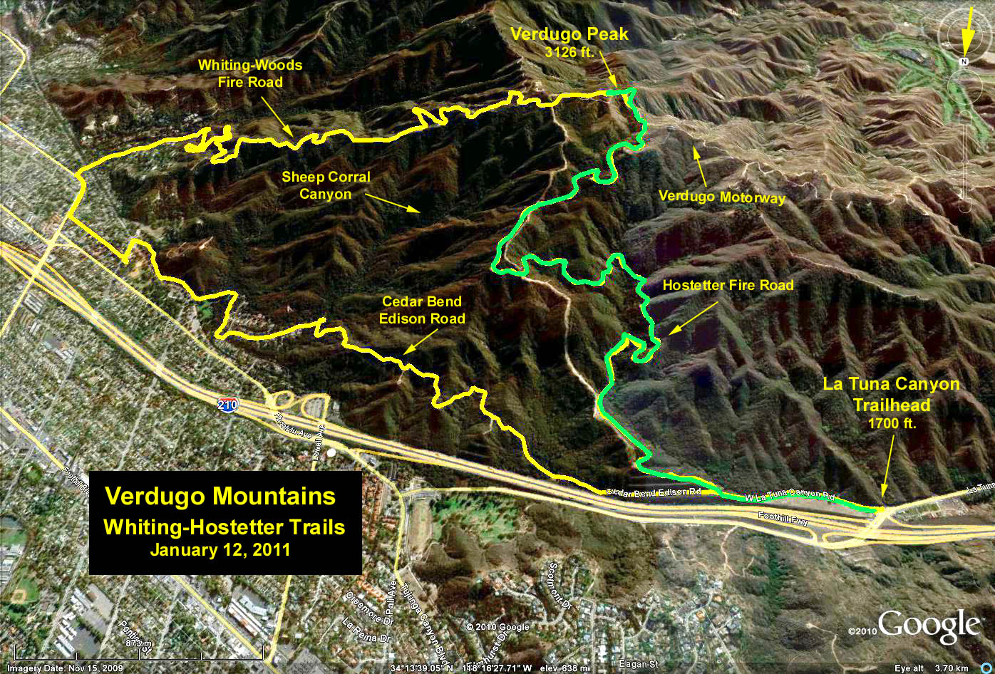
Trailhead Directions: The starting point is located at a parking area on the left side of La Tuna Canyon Road. For those coming from the west, it is just across La Tuna Canyon road at the off ramp from the 210 Freeway. For those coming from the east it is on the left side just after crossing under the freeway underpass from the La Tuna Canyon Road off ramp of the 210 Freeway. Be aware that there are no restroom facilities at the trailhead.
The Hike: After passing through the gate we follow the paved access road .4 miles to a junction and a gate. Here we turn right and go 2.7 miles up Hostetter Fire Road to Verdugo Fire Road and from there we turn left on Verdugo Fire Road about .4 miles to Verdugo Peak. After lunch we return for a total distance of about 7 miles. Or you can just go as far as you want and turn around.
The alternate hike is a strenuous loop a little over 10 miles. At the junction of Hostetter Road we continue straight through the gate on the Edison road (on our return, we will come down Hostetter Fire Road, which is the road to the right). We wind along and up and down this dirt access road about 1.8 miles until we reach another gate. For the next 1.7 miles we walk on city streets and through a park.
We start down Cedarbend, left on Forestglen, right on El Lado where we enter a trail through Crescenta Valley Park for .6 miles. After the park we walk along Mills, then right on Pennsylvania, and continue until it makes a slight jog left. We then turn right on Whiting Woods Road and go to the gate at the end. We go through the gate and up Whiting Woods Fire Road for 2.4 miles. We then turn right on Verdugo Fire Road and go .7 miles to the junction. Along this section of the road the trail to Verdugo Peak is off to the left, maybe our lunch spot. Returning, at the junction we go right down Hostetter Fire Road 2.7 miles to the gate at our first junction. We turn left at the gate and head down .4 miles to the cars.
Refreshments will be provided at the end of the hike.
Google Earth photo - Verdugo Mountains from La Tuna Canyon
GPS Data:
Main Hike: RT = 7.2 mi., 1350 ft.
Alternate Hike: RT = 10.8 mi., 1830 ft.