Distance: 10 mi. RT
Elevation Gain: 1100 ft.
Directions to Trailhead: Drive 20 miles west of the Malibu Canyon Road on the Pacific Coast Hwy. to Sycamore Canyon Campground. There is a day use parking fee. There are restrooms available in the campground.
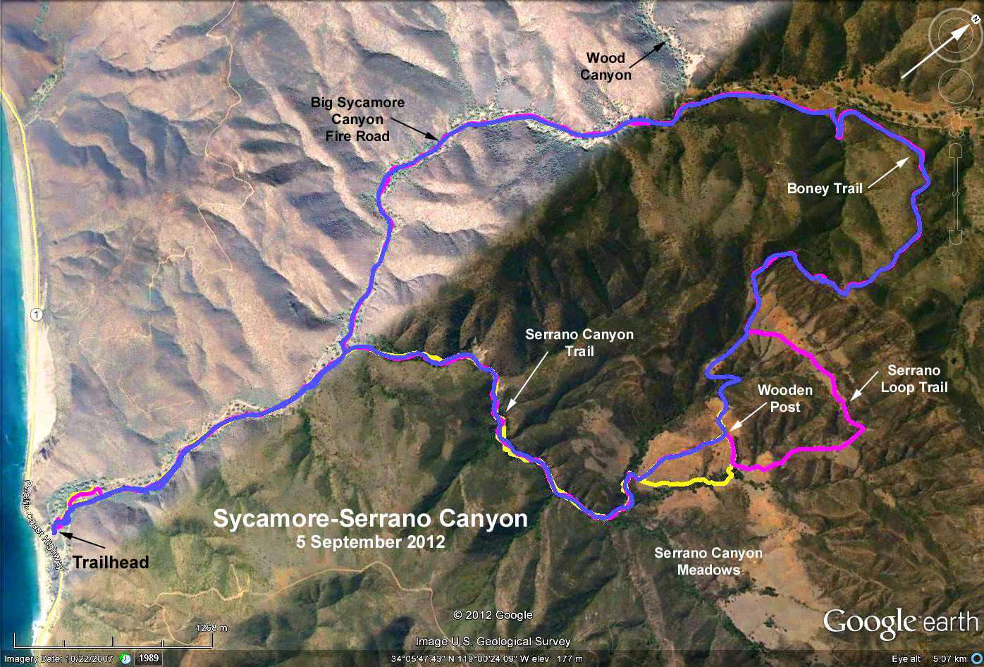
The Hike: A mile and a half after leaving the campground you will pass the Serrano Canyon Trail on the right. That will be the trail that you will use to return to the trailhead later. Continue up the gently graded Sycamore Canyon, occasionally crossing the stream. About 1.5 mi. past the Serrano Canyon Trail junction you will approach the Wood Canyon Trail junction. Stay to your right passing the junction and continuing up Sycamore Canyon.
After another 0.5 mi, take the signed Boney Trail beginning to your right that soon steeply climbs 800 ft. up and over the ridge separating Sycamore Canyon from Serrano Canyon. Along the top of the ridge, take in the spectacular view of Sycamore Canyon, the grasslands of Serrano Valley to the south-east, and Boney Mountain with its many peaks jutting out to the east. Continue past the signed junction of the Backbone Trail that goes off to your left.
Follow the Serrano Valley Trail south downhill into Serrano Valley eventually reaching a junction with the Serrano Loop Trail leading off to your left. The prescribed hike continues on the Serrano Valley Trail past this junction eventually crossing an intermittant stream, then rising and continuing east along a low ridge. Look for a single wooden post (unsigned except for some arrows) in the middle of this ridge and turn right (do not continue east), and follow this trail south eventually meeting another trail coming in from the left. Turn right at this point and continue on the Serrano Canyon Trail.
The Serrano Canyon Trail goes through some chaparral, then very quickly enters the steep-walled, solid rock, water formed gorge, connecting the higher Serrano Valley with the Sycamore Canyon downstream. Watch out for Poison Oak. Upon reaching the Big Sycamore Canyon Trail, turn left and return to the trailhead.
Option 1: An option would be to take the Serrano Loop Trail by turning left and then proceeding clockwise around the loop then south-east on a trail until it meets the Serrano Valley Trail at the junction with the Serrano Valley Trail described above.
Option 2: Take the Serrano Canyon Trail into Serrano Canyon and beyond into the valley. Explore the valley's grasslands as long as you wish, then return to the trailhead the way you came.
Caution: There are a number of trails that cross the meadow forming a large and a small loop interconnecting with one that crosses the meadow in an east-west direction. This latter trail eventually meets the Serrano Canyon Road which leads up and out of the canyon, and is not the way back to the trailhead.
Option 3: Continue up and back Sycamore Canyon as far as you wish (about 9 mi. RT to Danielson Ranch).
Google Earth Photo - Sycamore Canyon - Serrano Valley Loop
Original 2003-06-1 Hike 665 Description
GPS Data:
Prescribed Hike (blue trace): 9.8 mi RT; max. elevation = 1070 ft.
Serrano Loop (magenta trace): 10.4 mi RT; max. elevation = 1070 ft.
Serrano Canyon (yellow trace): 7.3 mi. RT; max. elevation = 660 ft.
2017-07-08