Distance: To Echo Mountain = 7 mi. RT; max. elevation = 1400 ft.
Mt. Lowe Railway Tour (to Inspiration Point) = 12 mi. RT; max. elevation = 2800 ft.
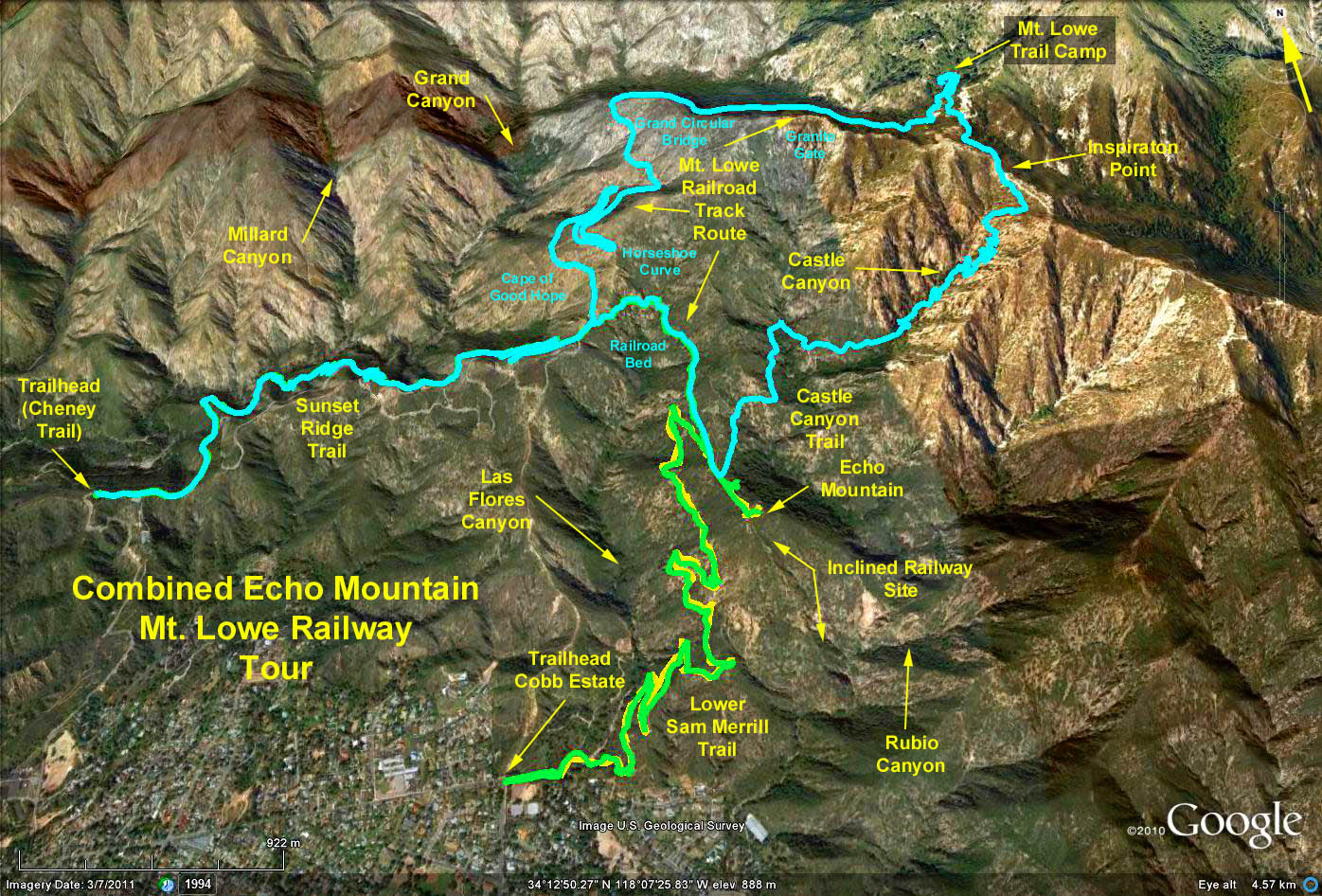
Area History: The old Mount Lowe Railway is long gone, yet once it attracted tourists by the thousands who took the thrilling ride up the cable incline to Echo Mountain, then the twisting trolley trip to rustic Ye Alpine Tavern on the slopes of Mt. Lowe.
When the mountain railway was built, it was considered one of the engineering wonders of the world. The Mt. Lowe Railway and resort complex was the idea of two visionary Pasadenans, Civil War balloonist and inventor Thaddeus S. C. Lowe, and engineer David J. Macpherson. With Lowe supplying the capital and Macpherson directing operations, the railway was hacked out of the mountainside in three stages during 1892 to 1895.
First was a trolley line from Altadena into Rubio Canyon, where the first of Lowe's Rubio Pavilion was located. Then an incline railway climbed 1300' to Echo Mountain, where two hostelries, The Chalet and Echo Mountain House were perched. Finally, a 4 mile winding trolley ride, past viewpoints such as Horseshoe Curve, Cape of Good Hope, Grand Circular Bridge and Granite Gate, carried visitors up to Ye Alpine Tavern (later called Mt. Lowe Tavern). Lowe was bankrupted by the venture, and for most of the 43 years of its operation, the Pacific Electric Railway Company ran the complex. From its opening in 1893 until the burning of Mt. Lowe Tavern in 1936, an estimated 3,100,000 persons visited the renowned mountain railway and resort complex.
Above Echo mountain, the scars of the winding railway are clearly visible today, and it is possible to hike to the tavern site along its broken bed, the upper section of which is now part of the Sunset Ridge-Mt. Lowe fire road. At the old tavern site, the Forest Service has constructed the Mt. Lowe Trail Camp, with tables, stoves, rest rooms and a spring fed drinking fountain. A half mile out from the trail camp, overlooking the San Gabriel Valley, are the foundations of old Inspiration Point, where tourists took in the view that was described in Mt. Lowe Railway days as breathtaking, beautiful, inspiring. Today, sadly, no such claims can be made. Only on those days when winter storms wash the sky clean can you see clearly, the megalopolis below.
Trailhead Directions: Exit the 210 just east of Devils Gate Dam on Arroyo/Windsor Blvd. Go north over the freeway and take the first right turn at Woodbury Road. After several blocks, turn left up Lincoln. Go a mile or so and turn right on Loma Alto Road proceeding to a left turn on the Cheney Trail signified by the flashing yellow light. Go up the narrow winding road to the top of Sunset Ridge, parking on each side of the road. Do not continue on the road which descends down to Millard Campground.
The Hike: Walk east on the Sunset Ridge fire road past a foot trail beginning at about 100 yards to the left, taking the second foot trail which contours north and east along Millard canyons south wall. After some climbing, you continue past a fork with a left branch (Millard Canyon Trail to Dawn Mine) on the signed Sunset Ridge Trail to the Sunset Ridge Mount Lowe fire road. Upon reaching the fire road, turn north and follow the fire road above Millard Canyon, passing such viewpoints of yesteryear as the Cape of Good Hope, Horseshoe Curve, and the most famous of all, Grand Circular Bridge. There is no bridge here now, just a sharp hairpin turn of the road.
After following the slope above Millard Canyon for a mile, you round the mountain and turn east high above Grand Canyon, passing through the remains of the rock outcropping once known as Granite Gate. Four miles from Echo Mountain, you finally reach Mt. Lowe Trail Camp, nestled in a grove of oak and spruce. The stone wall foundation just east of camp is all that remains of old Mt. Lowe Tavern.
From the trail camp, continue up the fire road, going right (southeast) at a road junction, one half mile to Inspiration Point. Immediately east of the point is an unmarked trail dropping into Castle Canyon. Follow this narrow trail as it zigzags steeply down Castle Canyon, around the head of Rubio Canyon, where you cross a small creek (usually water), and over to Echo Mountain, 2 miles. Continue east on the old railway bed rounding the head of Las FLores canyon until regaining the Sunset Ridge - Mt. Lowe fire road. Turn left and after 100 yards, descend the Sunset Ridge Trail to the trailhead.
Optional Hike - Echo Mountain: After turning north on the fire road, look for the beginning of the rail bed trail to Echo Mountain about 100 yards above and turn right. Return the way you came.
Alternative Hike 552 Description
Google Earth photo - Echo Mountain & Inspiration Point via Sunset Ridge & Castle Canyon Trails
GPS Data:
Railway Tour = 11.1 mi. RT; max. elevation = 2400 ft.
Echo Mountain = 7.3 mi. RT; max. elevation = 1380 ft.
2017-07-02