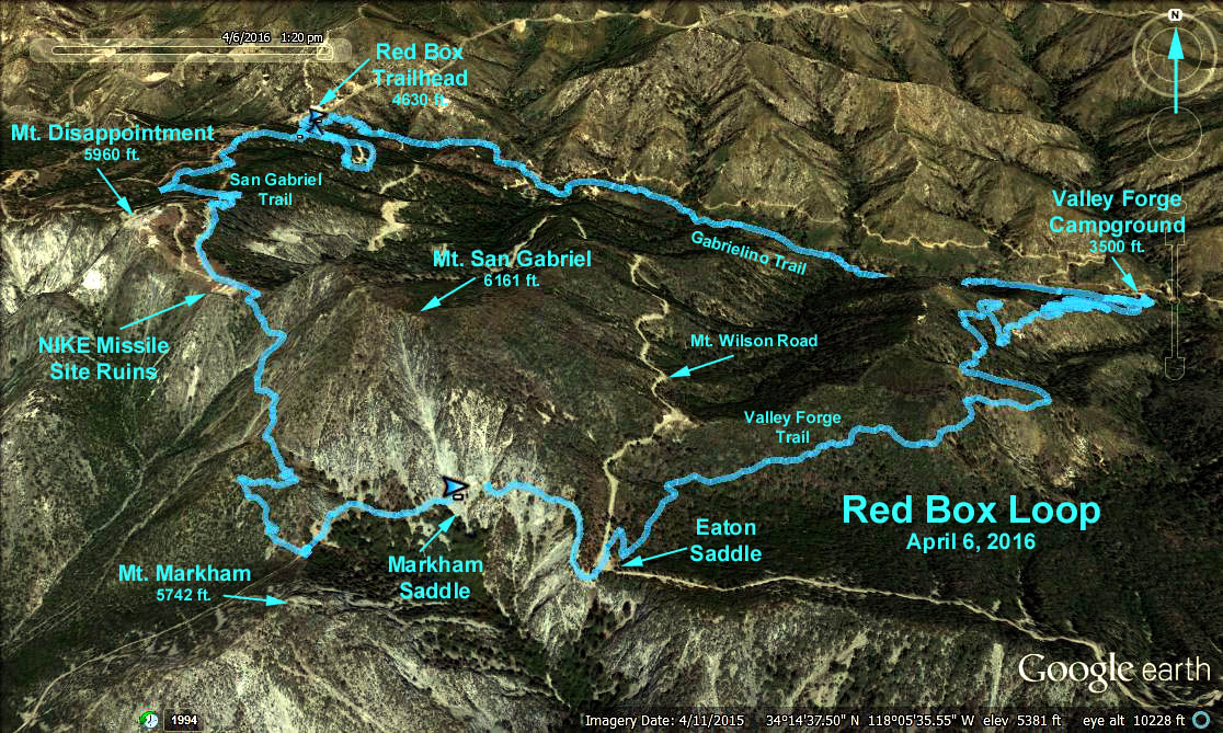
Red Box Loop
GPS Data:
Distance: 8.9 mi RT (includes Valley Forge Campground)
Cum. Elevation Gain = 2200 ft.
Elevations: Red Box = 4630 ft.
Disappointment - Gabriel Saddle = 5750 ft.
Valley Forge Canyon = 3500 ft.
Introduction: This is a loop for the ambitious and a shorter jaunt for those wishing for a more leisurely hike - all on good trail, and plenty of shade. The entire loop is 8.9 miles - going up 1120 ft. to the Mt. Disappointment-Gabriel saddle, dropping 2250 ft. to the Valley Forge Cmpground, and finally trudging back up 1130 ft. to Red Box. The shorter - 4.5 mile round trip - option returns to Red Box after reaching the saddle and walking to the top of Mount Disappointment.
Trailhead Directions: Meet at Red Box Station at mileage paddle 38.38 on the Angeles Crest Highway (about 14 miles from I-210 at the Mt. Wilson road turn off). Be sure to be there in plenty of time for a 9:30 departure.
The Hike: From Red Box we walk up the Mount Wilson Road for .4 mile to the Mt. Disappointment service road. The well maintained (built in 1988) San Gabriel Peak Trail starts from there. It wastes no time in zigzagging up the steep oak and conifer shaded slopes to the west. After about .6 mile the trail comes close to a stretch of the service road. It then resumes switchbacking, offering occasional views of the Mt. Wilson and West Fork country to the east.
The trail finally intersects the service road and after .2 mile reaches the road to Mt. Disappointment. After a well deserved cookie break we will break into two groups. One will go another 200 ft. gain and about a quarter mile to the top of Mt. Disappointment, a former Nike missile base, now an antenna site, then return to Red Box either by the service road (longer) or back down the San Gabriel Peak Trail.
The other group will continue the loop hike by going down the trail to Markham Saddle (bypassing Mt. Disappointment and Mt. San Gabriel). From there we head toward Eaton Saddle through the tunnel on the dirt service road. At Eaton Saddle we cross the Mt. Wilson Road to the beginning of the Valley Forge Trail. (Faint of heart hikers could return to Red Box via the Mt. Wilson Road).
Down we go on this shaded and well maintained (for the most part) trail - 2.6 miles and 1400 ft. drop - until we join the Gabrielino Trail. The upper part of this trail goes on a fairly straight course high on the west wall of Falls Canyon, the lower part switchbacks through the shade of tall chaparral, big cone spruce and oak trees. After turning left onto the Gabrielino trail we continue down for 0.1 miles to the junction leading to the Valley Forge Campground. Head down to the campground for lunch at the picnic benches.
After lunch and a stop at the restrooms there we head back up to the Gabrielino trail and then down 0.2 miles past a stone cabin before the trail starts back up. Then its up a little over 1000 ft. with one short level part just before we cross the service road, .7 mile from the Red Box parking lot.
Rest Rooms and Refreshments at Red Box
Original 1997-10-29 Hike 397 Description
Google Earth Photo - Red Box Loop
2017-07-01