West Valley Hike
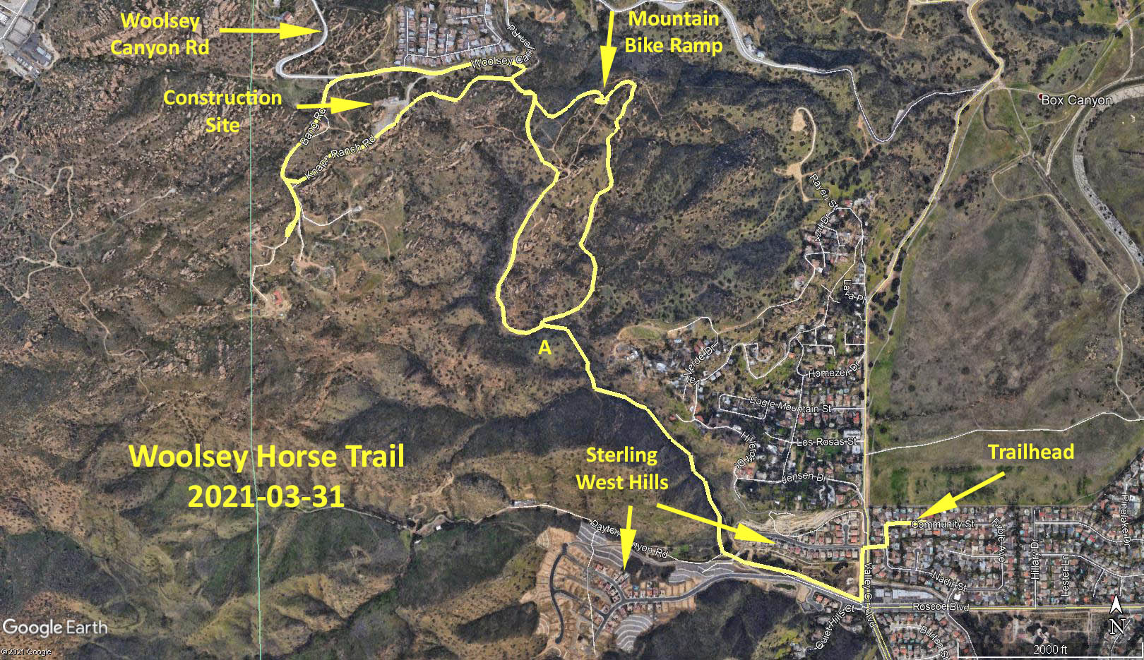
Woolsey Horse Trail
March 31, 2021
Meet at 9:00 am
GPS Data:
6.0 miles RT
771 feet elevation gain.
Directions to Trailhead: Head west on the 101. In Calabasas, take the Valley Circle Blvd. exit. Turn right at the end of off ramp. Continue for 4.85 miles. Pass Roscoe Blvd. Turn next right into Schoenborn. St. Turn left onto Starkland Ave. Turn right onto Community St. Jim’s home is 23725 Community St.
The Hike: Start from Jim Carlin’s home. Head west on Community St. Turn left on Starkland Ave. Turn right on Schoenborn St. Cross over Valley Circle Blvd. then turn left and head south on Valley Circle Blvd. until you reach Roscoe Blvd.
At 0.25 miles, turn right and pass under the “Sterling West Hills” arch. There is a small park on your right. Head down into a small canyon and head west with Roscoe Blvd. on your left. At 0.5 miles, pass under an iron bridge and immediately turn right into a shaded, tree-lined trail.
At 0.83 miles look to your left for two interconnected caves. Unfortunately, the paint is recent graffiti and not Chumash cave paintings.
At 1.0 miles you will reach a T-junction. Turn right (north) and head down a short but steep slope.
At 1.2 miles you reach a second T-junction. Turn right (east). On the return trip you will approach this junction from the westerly branch, so remember this location (A).
Continue on this gently rising trail in a generally northerly direction until mile 1.8. Keep to the main trail and avoid the numerous side trails. At 1.8 miles the trail makes a U-bend and heads in a south-westerly direction.
At 1.9 miles look to your right for a series of wooden and earthen mountain bike ramps. Look for broken bones!
This area, just to the south of Woolsey Canyon Rd. is spider’s web of intersecting trails. Don’t worry … you can’t really get lost since the Chatsworth Nature Preserve is visible to the east and the western end of the Sterling West Hills development is always visible to the south.
Look for a partially hidden trail to the right of the mountain bike ramps. This will take you in a westerly direction parallel to Woolsey Canyon Rd. The trail is called Knapp Ranch Road. At 2.5 miles you will come to a construction site with a building with big letters saying “Security”, the US flag, lots of straw wattles for erosion control and temporary plastic orange fencing. This relatively new construction has obliterated the original trail.
Those not wishing to take the trespassing chance, can retrace their steps, taking two right turns and heading in a generally southern direction, parallel to the outbound trail, until you reach location (A).
Those wishing to plough on, should head in a south-westerly direction, skirting the southern edge of the construction site. Eventually, at 2.6 miles you will see the trail emerge again after the construction site terminates. Follow the trail until 2.8 miles and then turn left onto a fire road called Sableski Ranch Rd. (not signed). A short distance ahead there are several forks to fire roads, however each will end at private property. There appears to be numerous auto dumps in the neighborhood.
Retracing your steps back along Sableski Ranch Rd., that becomes Bang Rd., you will reach Woolsey Canyon Rd. at 3.3 miles. Turn right on Woolsey Canyon Rd. and head downhill for 0.35 miles.
There are numerous separate and assorted “developments” along the right side of Woolsey Canyon Rd. (heading downhill) in this area. Entrances have assorted private property signs, though gates are open. However, there are no signs or fences when hiking north into this area from the south.
After walking for 0.35 miles down Woolsey Canyon Rd., immediately before a sharp left turn on Woolsey, look for a partially hidden trail off to the right. As soon as leaving the road, bear right, turn right, then turn left, then take the right fork. Continue in a generally southerly direction, parallel to the outbound trail, until you reach location (A).
From location (A), retrace your steps in a southerly direction, up the short steep hill, turn left, then along the shaded, tree-lined trail, past the caves on the right, then turn left under the bridge, and continue along the side of Roscoe Blvd. till you reach the little park on the corner of Roscoe and Valley Circle Blvd.
There are several picnic tables in the shade that are ideal for refreshments. Return to Jim Carlin’s for your cars following refreshments.
AllTrails – Woolsey Horse Trail
Google Photo Map - Woolsey Horse Trail
Updated: 2021-04-04