West Valley Hike
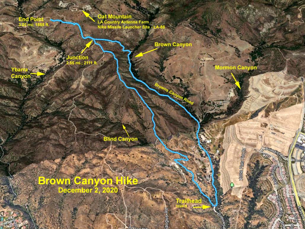
Browns Canyon
December 2, 2020
Meet at 8:00 am
GPS Data:
5.2 miles RT. 935 feet elevation gain.
Directions to Trailhead: From the 118 freeway travelling east take the De Soto Ave. exit and turn left (north) under the freeway. From the 118 freeway travelling west take the De Soto Ave. exit and turn right at the end of the off ramp. Turn immediately right onto Brown’s Canyon Road. On your way from De Soto to the trailhead you will also notice two signs saying … “Bridge Closed to General Public - Open to Residents Only.” The MRCA ranger said that we could ignore those signs, so don’t let them deter you from continuing. Go 1.1 miles to the southern end of the Michael D. Antonovich Regional Park. The address is 16100 Browns Canyon Road. Plug that in your GPS. The trailhead on the left has a sign saying “Santa Monica Mountains Conservancy Zone Parkland.” There is little parking so park off the road where available.
The Hike: Start on the trail going around the gate by the sign. Follow the trail in a gentle climb for 0.45 miles. Take the sharp right turn up a steeper slope for about 0.1 miles, then take a sharp left turn on the ridge. Stay on the ridgeline, avoiding a left fork into Blind Canyon at 0.75 miles and avoiding a right fork down into Browns Canyon after 1.45 miles. Continue along this ridgeline until 1.85 miles (total), then turn right onto a fire road (Curaco TR). In about another 0.2 miles (2.03 miles total), turn left onto Browns Canyon Road. A further 100 yards along Browns Canyon Road is a gate across the road preventing vehicle access up to the Nike Missile Site, LA-88, for anyone without a key to the locked gate. At 2.3 miles you will reach a fire road leading to the left. Another half mile along Browns Canyon Road would take you to the Nike Missile Site. Alternatively take the fire road for as far as you wish to go.
Return to the trailhead via Browns Canyon Road.
Map: Google Map of Browns Canyon
AllTrails: Track of 2020-12-02 Hike
Updated: 2021-01-15