Hike #1568
Echo Mtn. via Sam Merrill Trail
May 1, 2024
Hike Leader: Ron Obert
Meet at 8:00 am for start at 8:30 am.
Rabbits will start at a time to be determined..
Please print your own hike descriptions and maps.
GPS Data:
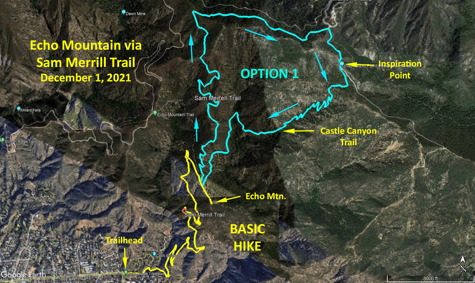
Basic Hike: 5.4 miles RT, 1,417 feet elevation gain
Basic plus Option 1: 9.2 miles RT, ~2,500 feet elevation gain
Directions to Trailhead: From the east exit the 210 freeway in Altadena at Lake Ave. and proceed north for 1.5 miles until Lake ends at Loma Alta Drive - park on the street.
From the west, exit the 210 freeway on N. Arroyo Blvd. / N. Windsor Ave. Turn left over the freeway. Turn right on W. Woodbury Road. Turn left on Fair Oaks Ave. Turn right on E. Loma Alta Drive. Park on the street at corner of E. Loma Alta Drive and Lake Ave.
Basic Hike: Echo Mtn. via Lower Sam Merrill Trail (5.4 miles RT, 1,417 feet elevation gain). The hike begins by entering the gate at the Cobb Estate and preceding east about 1/2 mile until reaching the San Merrill/Echo Mountain/Lowe RR trail heading north. Be careful not to turn to the north too quickly but wait until you descend into a small canyon, where the trail will be plainly marked. The trail is a constant climb up for another 2 miles, affording lovely views to the south (weather permitting). At the end of this trail (Echo Mountain), you can take a right turn with a short walk to the old hotel site, lunch, and return by the same route.
Option 1. Inspiration Point via Upper Sam Merrill Trail & Castle Canyon Trail (3.8 mile RT, approx 1,000 feet elevation gain).
For aditional miles, make a left turn before reaching the hotel and proceed up the Upper Sam Merrill Trail to Inspiration Point. Return via the Castle Canyon Trail.
BYO refreshments to Farnsworth Park, 568 E. Mount Curve Ave, Altadena, CA 91001, about 0.2 miles south of the hike trailhead.
Google Earth Map - Basic and Option 1
Map - Echo Mtn. via Sam Merrill
Updated: 2024-03-06