Hike #1567
Mission Peak from East Canyon
April 24, 2024
Hike Leader: Mariana Camacho
Meet at 8:00 am for start at 8:30 am
Rabbits start at a time to be determined
Please print your own hike descriptions and maps.
GPS Data:
Basic hike to peak and back: 9 mi. RT, max. elevation change = 1355 ft.
Meldon Canyon Option: (green + yellow trace): 10.9 mi. RT, max. elevation change = 1355 ft.
Directions to Trailhead: Exit at Calgrove Blvd. from northbound I-5 in Valencia (just past the I-5 & I-14 interchange). Turn left under the freeway bridge and go 0.9 mile south. Exit right on the first roadway past The Church of the Nazarene on your right, and work your way into a parking lot that parallels the road a choice of either parking off-pavement along road, or in a Santa Monica Mountain Conservatory parking lot guarded by a $5 Iron Ranger. There is a small park with a water fountain available, but no bathroom facilities. Such facilities may be available at businesses beyond the Calgrove off-ramp.
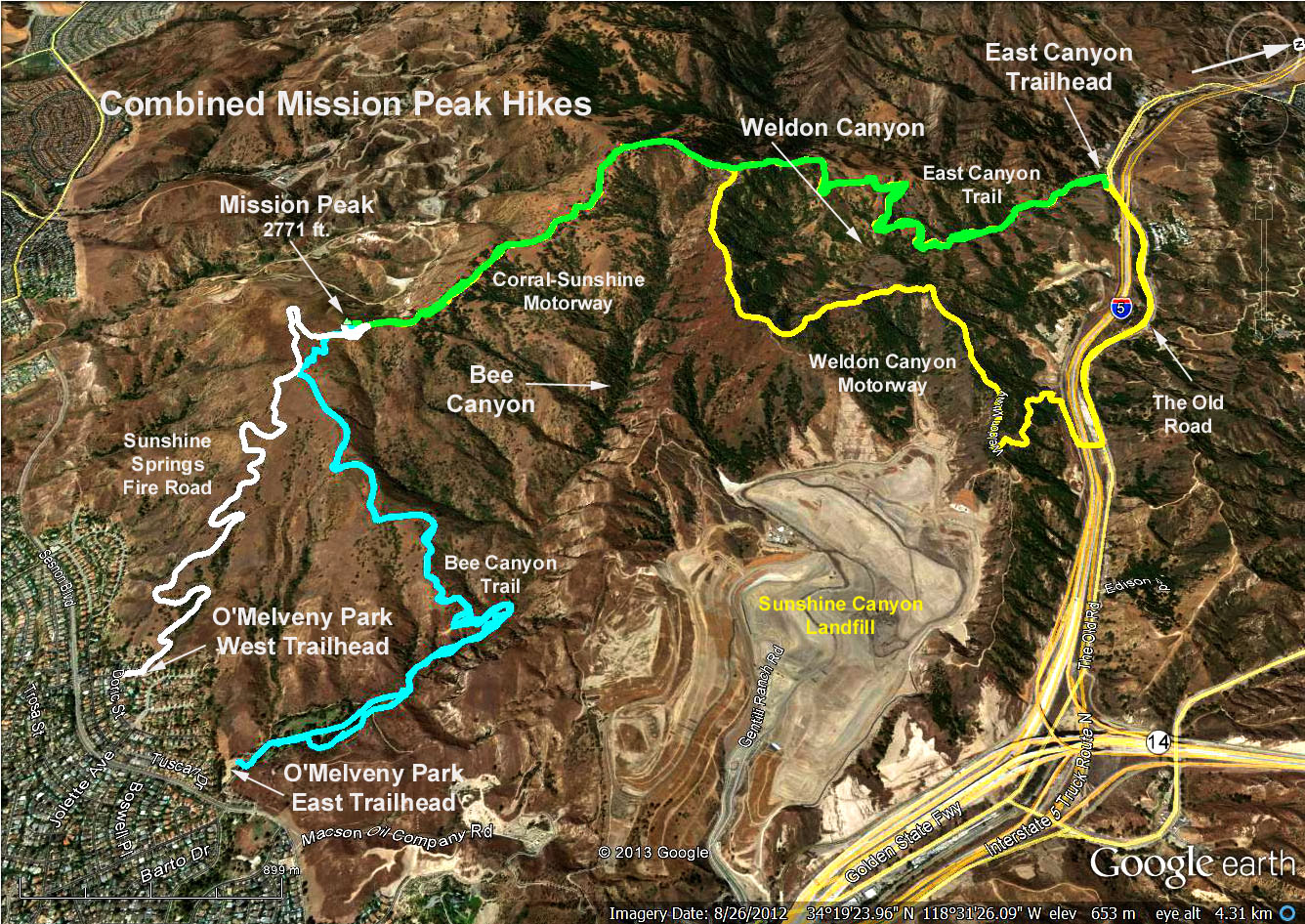
The Hike: We start on the East Canyon Motorway (green track), soon passing Rice Canyon Trail (signed) coming in from the right. The East Canyon Trail (also called the Saugus to the Sea Road on Google Maps) relentlessly climbs up the ridge until joining with the Weldon Canyon Motorway, a wider road coming in from our left (yellow post with Weldon). We continue straight ahead on what becomes the Sunshine Canyon Motorway. Views of the Aliso Canyon Gas Field can be seen on the right.
There is a sign indicating the direction to Mission Peak which is the Sunshine Canyon Motorway. After a series of right forks, take a sharp right turn to climb the rocky path to Mission Peak. Return is back the same way we came.
An alternate return path continues on the Weldon Canyon Motorway (yellow track) beyond the East Canyon junction. Once the freeway is in sight, take the road that turns acutely to the left. Turn right upon reaching the paved frontage road and cross the bridge over the freeway. Turn left and walk 1.6 miles back to the trailhead along the road.
BYO refreshments at the trailhead.
Google Earth Photo - Combined Mission Peak Hikes
Directions departing the trailhead: Exit the parking lot and head south (road is one-way at this point). Because of the I-5 & I-14 interchange, access to northbound I-5 occurs first (to Sacramento), then the Balboa bridge (right turn provides access for Valley people to the 118), then a southbound I-5 on-ramp finally becomes available (on the left) after some 2-3 miles.
Updated: 2024-03-06