Hike #1565
Mt. Lowe Summit, Inspiration Point Loop
April 3, 2024
Hike Leader: Jim Wolff
Meet at 9:00 am for start at 9:30 am
Rabbits start at a time to be determined
Please print your own hike descriptions and maps.
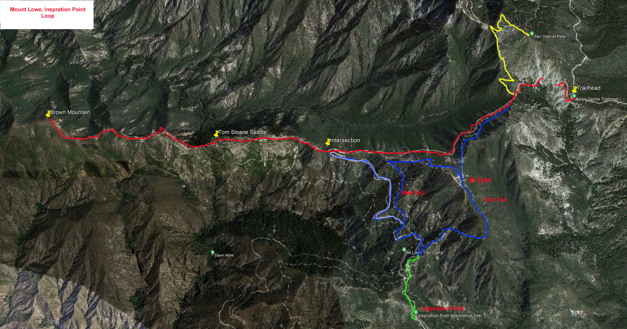
The Hike Summary
Basic Hike: Eaton Saddle Trailhead to Mount Lowe Point and Inspiration Point, ~6.4 miles RT, cum. elevation gain = 1,135 ft. Remember to take your Adventure Pass for your vehicle.
Map Legend:
Basic Hike - Blue
Option 1 and 2 – Red
Bonus Peak - Yellow
Directions to Trailhead: From the 210 Freeway drive north on Angeles Crest Hwy (Hwy 2) for 17.4 miles to the Red Box parking area on the right (south) side of the road. From Red Box take Mount Wilson Road 2.3 miles to unsigned Eaton Saddle and park there.
Mount Lowe Summit: From Eaton Saddle head up the fire road to the unsigned Markham Saddle and the intersection with the Mt. Lowe East Trail. Blue on hike map below. May be hiked clockwise or counterclockwise (recommended). Then take the Mount Lowe East Trail and make a gentle climb to East-West Trail Junction and make a right hand "U" turn and continue climbing on the West Trail till you reach the top of Mount Lowe. If you don't want to go any further, you may return the way you came.
Mt. Lowe Summit Egress: From the top of Mount Lowe descend a little bit till you come to a "Y" and take the left hand branch and continue descending on the West Trail. This descent is steep. Eventually you reach the fire road and make a left turn. As you go down the gently descending fire road you will notice there are two trails marked Mount Lowe East Trail. It branches into two trails near the bottom, so when you go back take the one you come across first.
Inspiration Point Leg: Shortly thereafter you come to a "Y" of the fire road. Take the left branch. After a short gentle climb you reach the Inspiration Point where there is a shelter and a great lunch spot. If you don't want to go any further take the East Trail back which is a pretty steep uphill climb (about 1000 ft.). When you reach East-West Trail junction be sure to stay on the East Trail (right hand side branch going down).
Fire Road Option to Return: If you do not like the steep climb, take the road back all the way to the trailhead. Light Blue on the map below. Retrace your steps back to the intersection of the West Trail and continue on the fire road to the noted intersection with the Tom Sloane route then turn right and continue back to the trailhead.
Hike Options:
Option 1: Tom Sloane Saddle. Red on hike map below. From Markham Saddle continue hiking (generally to the west) on the fire road to a place where the trail makes a sharp 180 degree turn to the left (south and then toward the east – Blue trail on hike map). Here you will find the intersection with the Tom Sloan Saddle trail leading to Brown Mountain.
Option 2: Brown Mountain Summit – Red on the hike map below. From Tom Sloane Saddle continue west on the use trail (toward the left heading up) that leads to Brown Mountain summit. Be advised that this is a faint use trail that is challenging with many false summits and additional elevation gains and losses. At the summit of Brown Mountain take a break and enjoy the views and return on the same trail/fire road to Eaton Saddle. Refer to video link below.
Bonus Peak – San Gabriel Peak – Yellow on the hike map below. For those that want a shorter hike or want to bag an additional peak. The San Gabriel Peak trail is located near the trailhead on the right (north). Partially noted on the hike map in yellow.
Note: All options can be mixed and matched to create shorter or longer/easier or harder hikes.
Video: Hiking Brown Mountain – Mike On The Trail YouTube Dated 2023-04-23: https://www.youtube.com/watch?v=mF9hMKHtLa4
Updated: 2024-03-28