Hike #1559
January 31, 2024
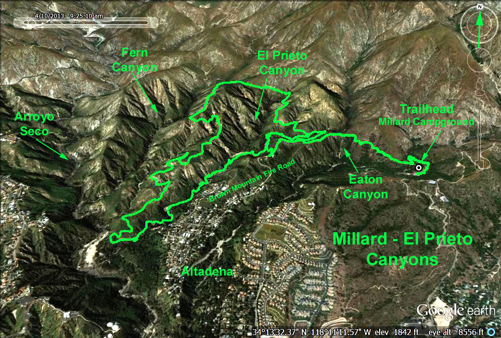
Millard & El Prieto Canyons
Hike Leader: Rich Frederick
Meet at 9:00 am for start at 9:30 am.
Rabbits will start at a time to be determined.
Please print your own hike descriptions and maps.
Directions to Trailhead: Exit the 210 freeway at Lincoln Ave. and continue north into Altadena. Turn right (east) at Loma Alta Dr. and proceed half a mile to the blinking light at Chaney Trail. Turn left and follow Chaney Trail to its end (past our usual parking place), and park in the Millard Campground parking lot near the locked entrance to Brown Mountain Fire Road (1,800 ft.). There are restrooms at Millard Campground.
The Hike:
Option 1: Proceed 1.1 miles up the fire fire road, past Millard Camp, to a junction on the ridge between Millard and El Prieto Canyons (2,020 ft.). Turn left and hike down the trail 0.25 mile to a locked yellow gate. A few feet past the gate turn right down the trail into El Prieto Canyon bearing right at the next trail junction (1,980 ft.) then following the main trial that will eventually curl left up onto Brown Mountain Fire Road. Turning right down the fire road at this point will return you to the junction (2,020 ft.) and the trailhead. This version of the hike will get you 3.2 miles.
Option 2: By turning left and proceeding upward on the Brown Mountain Fire Road, youll soon spot, about a mile ahead, the piney gap between El Prieto and Fern Canyons. This junction and flat spot (2,390 ft.) is a good terminus for many. From the gap, returning to the trailhead down the fire road will result in a hike of 5.8 miles with 900 feet of gain.
Option 3: Crossing the gap, continue west then south down the fire road toward JPL. At 3.1 miles and 1,100 ft. below the piney junction, the road drops into the canyon to the stream (1,310 ft.). At this point turn left and follow the canyon, stream, and trail upward past the trail junction (1,980 ft.) back to the fire road. Turn right to return to the trailhead resulting in a hike of 8.4 miles.
Extra Side Trip to Millard Falls: After 0.2 miles from the trailhead, take a right turn into the Millard Falls Trail. Walk 0.8 miles to Millard Falls. Take a shower! Return to the Millard Canyon road, turn right and continue. This side trip is not shown on the map and will add 1.6 miles and 275 feet to the data below.
For you history buffs from Trails of the Angeles, The Brown Boys Owen and Jason were familiar figures in and around the foothills of the front range back in the 1880s. These long bearded sons of the fiery pre-Civil War abolitionist John Brown lived in a small log cabin near the head of El Prieto Canyon, a beautiful wooded glen between the Arroyo Seco and Millard Canyon.
GPS Data:
Option 1 = 3.2 mi. RT, max elevation change = 380 ft.
Option 2 = 5.8 mi. RT, max elevation change = 910 ft.
Option 3 = 8.4 mi RT, max elevation change = 1085 ft.
Google Earth photo - Millard and El Prieto Canyons
Updated: 2024-01-04