Hike #1546
October 11, 2023
Hellman Park via Turnbull Canyon
Hike Leader: Randy King
Meet at 9:00 am for start at 9:30 am. Note the later start time because the parking lot gate opens at 9:00 am.
Rabbits will start at a time to be determined.
Please print your own hike descriptions.
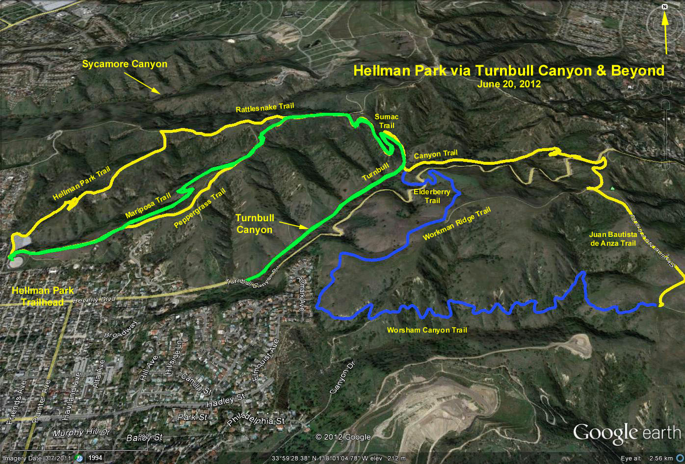
Please note changes to the original Google Earth Photo on the new Google Earth Photo. The Hellman Park Trail is seriously fenced off with penalties for trespass. The blue Elderberry Trail DOES NOT connect with the Canyon or Turnbull Trail.
GPS Data (See NEW Google Earth photo below):
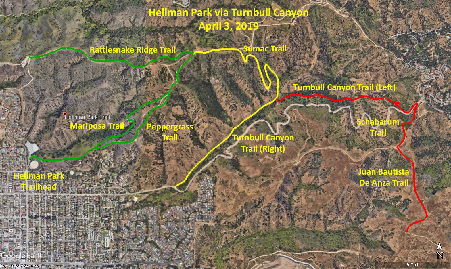
Basic Hike (green trace): RT = 4.2 mi.; max. elevation change = 880 ft.
Alternative Hike #1 (green and yellow trace): RT = 5.4 mi.; max. elevation change = 640 ft.
Rattlesnake Trail Extension of 1.8 miles = 7.2 miles RT.
Alternative Hike #2 (green, yellow and red trace): RT = 7.4 mi.; max. elevation change = 880 ft.
Directions to Trailhead: From the south, take I-605 and exit at Whittier Blvd. (south). Go 1.1 miles southeast on Whittier Blvd to Hadley and turn left. Go 0.9 mile to Greenleaf and turn left. Go 0.6 mile on Greenleaf to 5700 Greenleaf, just past Orange St. The entrance to the Hellman Park parking lot is on the right. From the north, take I-605 and exit at Beverly Blvd. (east). Go 2.1 miles on Beverly Blvd., then turn left on Greenleaf Ave. The Hellman Park Trailhead is 0.1 miles on the right.
Parking: Gates to the park and parking lot open a little before 9:00 am. There will likely be a line of cars waiting for the small number of spaces in the lot (approx. 20) which will quickly fill up. There is no parking on Greeleaf north of the park entrance. Street parking in the immediate vicinity and south of the trailhead is by permit only. This includes south on Greenleaf for 2.5 blocks down to Broadway, and east and west on Orange Drive. Essentially, the only available street parking within a reasonable distance from the trailhead is east and west on Beverly Blvd.
Amenities: There is a big portable toilet at the trailhead. There are no picnic tables or chairs so please bring chairs.
Basic Hike: Hellman Park enables one to access the entire 4,000 acres of the Native Habitat Preservation Authority’s lands extending from Whittier on the west to Powder Canyon on the southeast in Hacienda Heights. Since the Hellman Park Trail has been fenced off, take the Mariposa Trail, which goes steeply northeast. When you come to a split, you can continue on the Mariposa Trail to the left or go right onto the Peppergrass Trail. The Mariposa trail is not as steep and ends up rejoining the Peppergrass Trail further on. The Peppergrass Trail in 1.2 miles joins the Rattlesnake Ridge Trail, where a LEFT turn brings you in 0.9 miles, to a communications tower where you meet the fenced off Hellman Park Trail. Turn around and go back the way you came on the Rattlesnake Trail and the Peppergrass Trail.
Alternative Hike #1: Take the Peppergrass Trail, which goes steeply northeast. The Peppergrass Trail in 1.2 miles joins the Rattlesnake Ridge Trail. Go RIGHT at this junction and go 0.2 mi. east on a level path to a junction with the Sumac Trail where you turn right and go down 0.6 mi to an intersection with the Turnbull Canyon Trail. Turn RIGHT and continue on the Turnbull Canyon trail downhill for 0.7 miles until it ends upon reaching Turnbull Canyon Road. Return to the trailhead the way you came. RT = 5.4 mile. Consider adding the Rattlesnake Trail extension to the communications tower for an additional 1.8 miles RT, for an 7.2-mile total.
Alternate Hike #2: Take the Peppergrass Trail, which goes steeply northeast. The Peppergrass Trail in 1.2 miles joins the Rattlesnake Ridge Trail. Go RIGHT at this junction and go 0.2 mi. east on a level path to a junction with the Sumac Trail where we turn right and go down 0.6 mi to an intersection with the Turnbull Canyon Trail. Turn LEFT onto the Turnbull Canyon Trail, and in 0.6 mi. you will come to a junction with the Schabarum Trail coming down from your left. Continue straight ahead east on the Schabarum Trail, which in 0.4 mi crosses Turnbull Canyon Road and in a few feet makes a sharp right turn. In 0.2 mi you will cross under the Tehachapi Power Line and reach a road. Turn left on this road, part of the Juan Bautista De Anza Trail Historic Route; pass a little knoll on your left strewn with girder wreckage and in 0.5 mi come to a junction with the Worsham Canyon Trail. This is a good turn around point. Go back the way you came.
Those wanting a shorter hike could turn around at any place on the route. A stop for lunch would be ideal anywhere in the shade of Turnbull Canyon.
BYO refreshments at the trailhead.
ORIGINAL Google Earth Photo - Hellman Park, Turnbull Canyon & Beyond
NEW Google Earth Photo - Hellman Park via Turnbull Canyon
Updated: 2023-10-09