Hike #1529
Hollywood Sign from Brush Canyon
May 31, 2023
Hike Leader: Sonia Sahyouni
Meet at 8:00 am for start at 8:30 am
Rabbits will hike promptly at 7:00 am
Please print your own hike descriptions and maps.
GPS Data:
Distance Basic Hike: 6.4 mi. RT
Max. Elevation Gain: 1,050 ft.
Directions to Trailhead: Address: 2734 Canyon Dr. Los Angeles, CA 90068.
From the North: Head south on 101 and take exit 8C, North Gower Street. Turn left on North Gower Street to go under the freeway. Turn right on Franklin Avenue and go to Canyon Drive. This may be the last point to stop for a bathroom break at the Gelsons Market. Turn left on Canyon Drive and
go to the end of the road.
From the South: Head north on 101 and take exit 8C, North Gower Street. Turn right on North Gower Street and turn right on Franklin Avenue and go to Canyon Drive. This may be the last point to stop for a bathroom break at the Gelsons Market. Turn left on Canyon Drive and go to the end of the
road.
Parking is free in the lots along Canyon Drive or on the street. There are two lots, a small one at the trailhead and a larger one near the Bronson Caves, less than a quarter mile away.
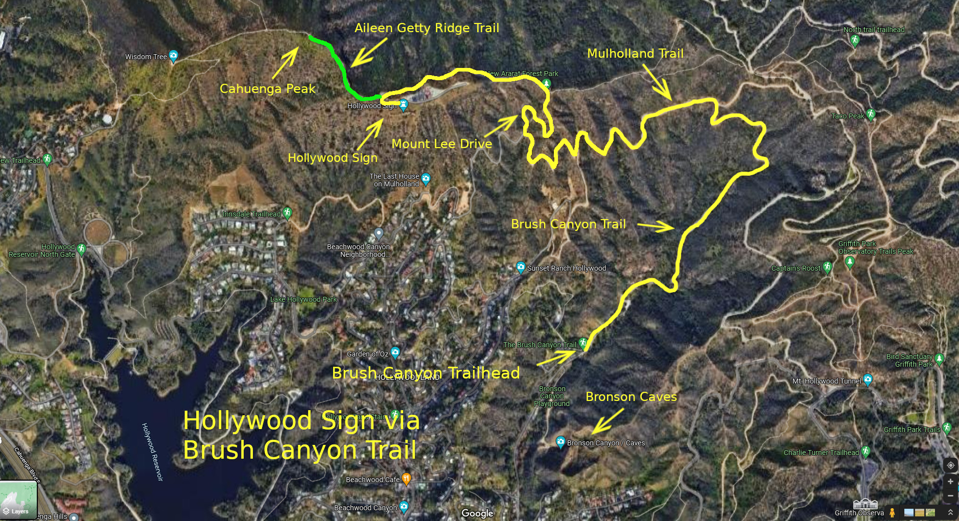
Description of the Hike: The hike starts near the famous Bronson Caves, also known in the movie industry as "The Bat Caves". Then we head up the Brush Canyon Trail to an overlook of Los Angeles and a photo opportunity with the Hollywood sign. We continue on to merge with the Mulholland Trail, which allows for a nice view of the Griffith Observatory. Finally we join Mount Lee Dr. to hike up behind the Hollywood sign and 360 degree views of Hollywood Reservoir, Los Angeles, Burbank, the Verdugo Mountains, and the San Gabriel Mountains.
Basic Hike: Go past the gate at the north end of Canyon Drive to enter the Brush Canyon Trail. Near the top of the canyon at 1.25 miles, there is an overlook with views of Los Angeles and a photo opportunity with the Hollywood sign. Continue on Brush Canyon Trail and turn left (west) to merge with Mulholland Trail (Fire Road) towards Mount Lee Drive. Go past the junction with the Hollyridge Trail coming up from the left. Mulholland Trail ends at the paved Mount Lee Drive, 2.25 miles from the start, turn right to go uphill. Along the way at the last hairpin turn is a bronze plaque mounted on a rock thanking all those who were instrumental in saving Cahuenga Peak from developers. This is the trailhead for those that want to extend the hike to Cahuenga Peak. At the end of Mount Lee Drive is the Hollywood sign.
Option 1: To extend the hike further, you can hike to Cahuenga Peak. This narrow, rugged trail with dramatic views takes you to the 1820' highest peak in Griffith Park. Return back to the brass plaque on the rock at the last hairpin turn on Mount Lee Drive, about 0.15 miles. This is where the Aileen Getty Ridge Trail begins. Follow the Aileen Getty Ridge Trail for a third of a mile to get to the peak.
Option 2: Be sure to walk down from the Canyon Dr. trailhead and explore the Bronson Caves. This can be done either before or after the hike.
History:
Hollywood Sign: Originally built in 1923, the Hollywood sign will soon celebrate it's century mark. A group of investors, including Los Angeles Times publisher Harry Chandler, ordered a huge wooden sign built atop Mt. Lee to make sure that everyone knew about their new real estate development. The sign read: "HOLLYWOODLAND." The Beachwood Canyon Development was advertised as "above the traffic, congestion, smoke, fog and poisonous gas fumes of the lowlands." Looking back now, it's hard to believe Angelenos were worried about pollution in the early 1920s. During it's lifetime, the sign fell
into irrelevance and severe disrepair, before finally being recognized as a civic treasure to be restored and protected. On November 11, 1978, the latest restoration of the sign was completed making it the largest sign in the world. Each letter stands 45 ft tall and the whole sign is 450 ft long. Besides the sign, 1,640-foot Mt. Lee has another claim to fame: L.A.'s first television signals were broadcast from the peak in the 1940s.
Cahuenga Peak: At 1,820 feet, Cahuenga Peak is the twelfth highest summit in the Santa Monica Mountains and the highest summit in Griffith Park. Cahuenga Peak was purchased by Howard Hughes with intentions to marry Ginger Rogers and build her a home there. She refused his offer and the land remained undeveloped. In 2002, a group of investors set out to build a 5 luxury estates on the peak. Locals, city leaders and conservationists raised money to buy the land but could not raise enough money. Eventually the Trust for Public Land launched its Save Cahuenga Peak campaign. This included draping the Hollywood Sign so that it read "SAVE THE PEAK". In 2010, they finally had enough money to purchase the land and donated it to the city of Los Angeles to become part of Griffith Park.
Bronson Caves: The caves were originally a quarry, the crushed rock from the caves used to pave the streets of a growing Hollywood. The many western and science fiction movies that were shot from the caves included Star Trek, Mission Impossible, Gunsmoke, Bonanza, and Batman & Robin.
Google Earth Map - Hollywood Sign
AllTrails Track - Hollywood Sign
Updated: 2023-04-24