Hike #1501
Trump Golf Course to Royal Palms County Beach
August 31, 2022
Hike Leader: Dennis Fassnacht
Meet at 8:00 am for start at 8:30 am
Please print your own hike descriptions and maps.
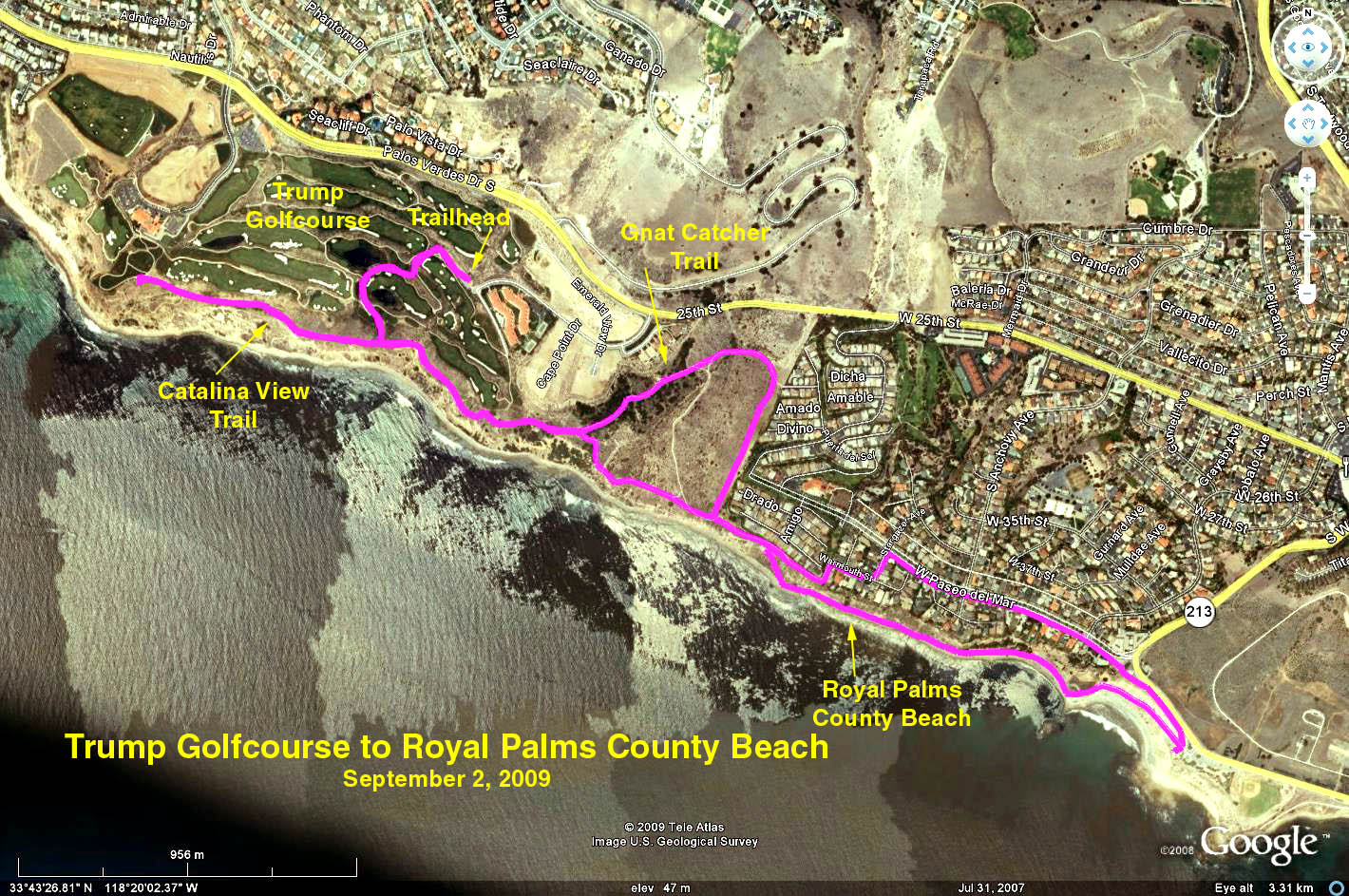
Distance: About 7 miles RT. Out and back. Elevation gain: About 700 ft. There is a public rest room at the start. Hike includes bluff walk, sloped trails, street walking, possible beach walking.
Directions to Trailhead:
From Far Away: South on the Harbor Freeway (SR-110) towards San Pedro to freeway’s end at Gaffey Street, turn left onto Gaffey. To avoid downtown, turn right on 1st street, then left on Western (213). Turn right on W. 25th Street (which continues as Palos Verdes Drive at the end). Go about 2 miles to La Rotonda Drive (small sign), turn left towards ocean and follow it downhill to the end. Turn right into the public parking area.
From South Bay: South towards ocean on Hawthorne Blvd, then left on Palos Verdes Drive. Turn right onto La Rotonda Drive, then right into the public parking area.
The Hike: The Lakeview Trail / Bike Way trailhead starts at the restrooms at the end of the parking area. As we walk through the golf course area, there are gray concrete paths for hiking and faded peach tinted concrete paths for golf. Stay off of the peach golf paths.
Out = Up the El Porto Trail to a pillbox, across top of canyon to E. Boundary Trail
At the bluff above the beach, turn left. Near here, our main hike takes the first trail to the left – see three big rocks (near intersection of the Switchbacks Trail down to water). Hike up the hill to see the pillbox remnants tight against houses – see where the cable is pulled down. Also good view of golf course. Continue on trail past the pillbox. The trail will turn right at base of some stairs. Do not take stairs. Along the trail, look for opening in cabled trail, with sign. Turn right. This trail goes down and across canyon to a wide E. Boundary Trail on opposite side. Cross the Shoreline/Gnat Catcher/etc. trails -- just stay on the same trail until you get across and dead end onto the E. Boundary Trail. Turn right to get back down to the bluff. At the ocean, turn left to continue. We then pass in front of a trailer park (notice Sotheby sale). The trail ends/turns left (see vegetable garden on left) and you walk straight onto Warmouth Street. Go left on Stargazer Avenue and right on Paseo del Mar which goes to Royal Palms/White Point County Beach. Choose to descend to water or not. It's nice on top too. See the great geological example of California on the driveway down-earth folded like a pancake several times over, a prime example of wave cut platforms. There also used to be a natural sulfur spring here, and it was a resort destination for that reason around 1915.
Back = Up and around difficult steps via Shoreline Park/Gnat Catcher Trails.
Retrace steps except turn up hill at Shoreline Park/Gnat Catcher Trail which is a little past the E. Boundary Trail where you came down on your way out. Important: this loop avoids the steep/step trail closer to the bluff.
Extra. Go Down to Water: there is a steep Switchbacks Trail, access to beach, near the trail from the parking lot and the Pillbox turnoff. (Plus two more closer to Trump.) Also, a map I saw showed climbing up from beach at Royal Palms to Paseo del Mar. Take a look to see about walking along base of cliff.
Suggestion: BYO refreshments in the parking lot. Bring chairs as there is no place to sit.
Google Earth photo - Trump Golf Course to Royal Palms Beach
2022-08-15