Hike #1482
April 13, 2022
Oak Springs Trail to Yerba Buena Ridge
Hike Leader: Ralph Shoukry
Meet at 8:00 am for start at 8:30 am. Note time change.
This is a replacement hike for Chantry Flat which remains closed by the Forest Service following the Bobcat Fire.
Please print your own hike descriptions and maps. This will save the hike leader the inconvenience and cost of providing descriptions/maps to you all.
GPS Data
Basic Hike: RT = 5.2 mi, max. elevation change = 1,235 ft.
Option 1: RT = 8.4 mi, max. elevation change = 2,096 ft.
Option 2: Not hiked - see hike description.
Option 3: RT = 9.1 mi, max. elevation change = 2,096 ft.
Directions to the Trailhead: Turn off the 210 Freeway at Osborn Street, which soon becomes Little Tujunga Canyon Road. Four miles from the freeway, Gold Creek Road angles off to the right. The new Oak Spring parking lot (complete with restroom) is 0.6 miles up Gold Creek Road. An Angeles Forest parking pass is required. From the parking lot walk another 100 yards up the road to the marked trailhead.
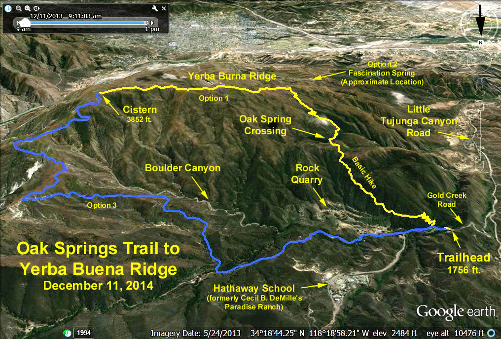
The Basic Hike: Oak Springs trail climbs up the southern slope of Gold Creek Canyon. The first mile is all up and offers views of the Hathaway School and the Mendenhall Ridge behind it. At 1.5 miles we reach Oak Spring, a small stream running through a shady grove. Cross the stream and continue south, generally upward for another mile to Yerba Buena Ridge and fire road. Return the way you came.
Option 1: Upon reaching the ridge, turn left and continue up the road to where the road reaches an obvious crest and a nearby cistern (adds 3.2 miles RT and 850 ft. elevation gain).
Option 2: To visit Fascination Spring, take the trail leading south off of the fire road. This trail is reasonably steep and not in very good condition (adds 2.2 miles RT with elevation loss of 900 ft.). NOTE: 2013 Internet trail reports indicate the trail is virtually indistinct, and one must pick their way down and then back up.
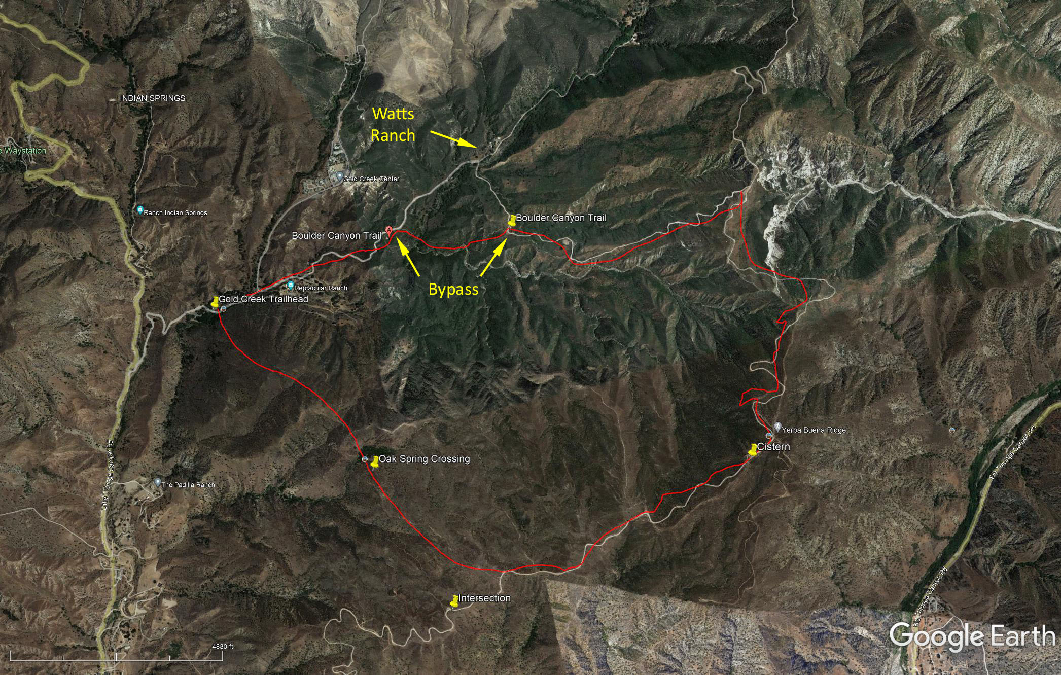
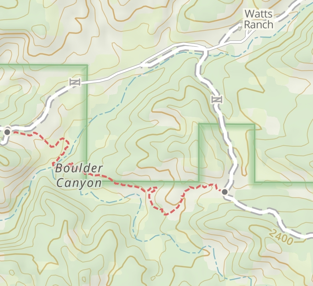
Option 3: Continue on the ridge road to Gold Canyon Saddle, turn to the left, then proceed along the northern ridge of Boulder Canyon past Watts Ranch, the old stone quarry (material used to build Hanson Dam), eventually coming out on Gold Creek Road and back to the trailhead (total loop distance = 9 mi RT, same max. elevation). Caution: Watts Ranch is private property. Do not use the trail shown on the Google Earth photo (note this map is upside down). Use the bypass trail shown on the bypass maps below.
Google Earth photo - Oak Springs Trail to Yerba Buena Ridge
Oak Springs Trail with Watts Ranch Bypass
Updated: 2022-04-09