Hike #1448
July 28, 2021
Solstice Canyon & Deer Valley Loop
Hike Leader: Phil Rutherford
Meet at 8:00 am for start at 8:30 am
Please print your own hike descriptions and maps. This will avoid the inconvenience and save costs to the hike leader.
GPS Data:
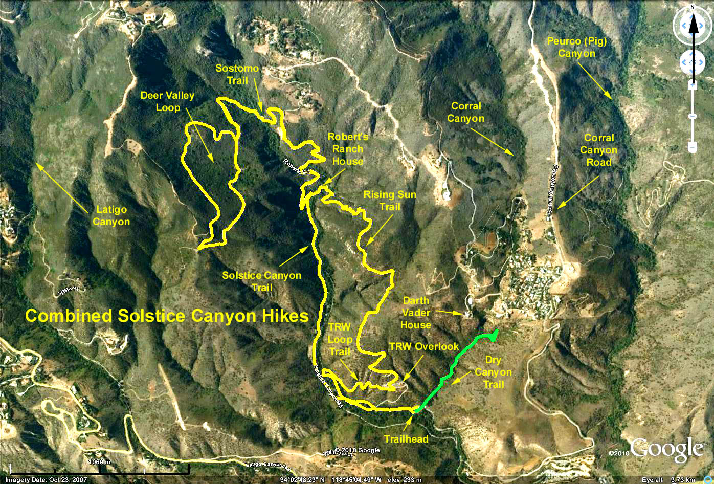
Basic Hike: RT = 3.4 mi. and 770 ft. elevation gain.
Deer Valley Loop: RT = 7.2 mi. and 1880 ft. elevation gain.
Dry Canyon: RT = 1 mi. and 130 ft. elevation gain.
Directions to Trailhead: Turn north off of Pacific Coast Highway at Corral Canyon Road, which is 2.5 miles west of Malibu Canyon Road. Within a couple of hundred yards turn left through the gate (opens at 8:00 am) and continue straight into the Solstice Canyon Park. The parking lot is about half a mile from PCH and has space for about 30 cars which can fill up quickly. Parking is free and there are restrooms.
The Hike: We head up the canyon road and veer left onto the trail near the picnic table and large oak. The trail crosses the road just before a bridge and after a couple hundred yards turns sharply right, at a green metal fence post. We climb eastward on the TRW Loop Trail and soon arrive at the foundations of two buildings, which were used by TRW between 1961 and 1973 to test spacecraft magnetometers. Both buildings burned to the ground in the 2007 Corral Canyon Fire.
Follow the trail across the pavement and up the ridge. Walking out the El Nido spur will give a good view of Corral Canyon and add 0.25 miles and 100 feet to the numbers stated above.
Continue up the steep Rising Sun Trail eventually getting to a long descending leg taking us to the ruins of Robert's Ranch House which was built in 1952. It featured exotic animals, several fireplaces, a bomb shelter, and a stone path that leads upstream to a waterfall. It must have been quite a party place, as it was seized as a part of drug convictions in the 70s. The place burned in 1982. Be sure to explore the ruins of the house, all of the stone work, the water fall and the grotto across the stream.
At this point one can return to the trailhead by walking the Solstice Canyon Trail or can take the Sostomo Trail up and out of the canyon. On returning via the Solstice Canyon Trail, note the stone house ruins located across from the road, accessible by a new bridge. This was built by Henry Keller as a hunting cabin in 1903, and was the first stone house built in the Santa Monicas. Although it survived many fires, it was finally destroyed in the 2007 Corral Fire.
The Sostomo Trail begins 0.1 miles below Robert's Ranch House. At the first stream crossing, make sure you cross the stream, not try to follow it stream upward. The foliage is heavy enough to preclude panoramic views of the canyon or ocean. You will pass a couple of old rock cabins that are worth a few moments of inspection.
The Deer Valley Loop Trail may be hiked in either direction. The easterly portion of the loop features some relatively flat meadow like areas, whereas, the westerly part is a bit higher and has a grand panorama of the Pacific. Near the southern end of the loop make sure you make the sharp bend, so that you don't end up in Latigo Canyon.
The Dry Canyon Trail starts below the Trailhead complex and runs 0.5 mile to a dead end at the vertical cliff supporting a number of houses (including the "Darth Vader" house). As of November 2019, this trail is still closed following the Woolsey Fire.
Google Earth photo - Solstice Canyon & Deer Valley
2021-06-16