Hike #1447
July 21, 2021
Point Vicente Through Terranea Resort
Hike Leader: Tom Kaczmarek
Meet at 8:00 am for start at 8:30 am
Please print your own hike descriptions and maps. This will avoid the inconvenience and save costs to the hike leader.
Trailhead Directions: From the 405 Freeway take Hawthorne Boulevard South, up and over The Hill to end of Hawthorne Blvd. at Palos Verdes Drive West. Turn left at the traffic light. (where youll find a Starbucks for coffee). Turn right at the next turn off, which will be the entrance to Point Vicente Interpretive Center, and park in the parking lot.
If you take the 110 South Freeway, take the Gaffey Street exit. Turn right on West 1st Street. In 1 mile, turn left onto N. Western Ave. In 1.7 miles, turn right onto W. 25th Street. W. 25th becomes Palos Verdes Drive South. In 6 miles, turn left into the Point Vicente Interpretive Center.
Note: There are restrooms available at the park, after 9 am. and at Terranea Resort.
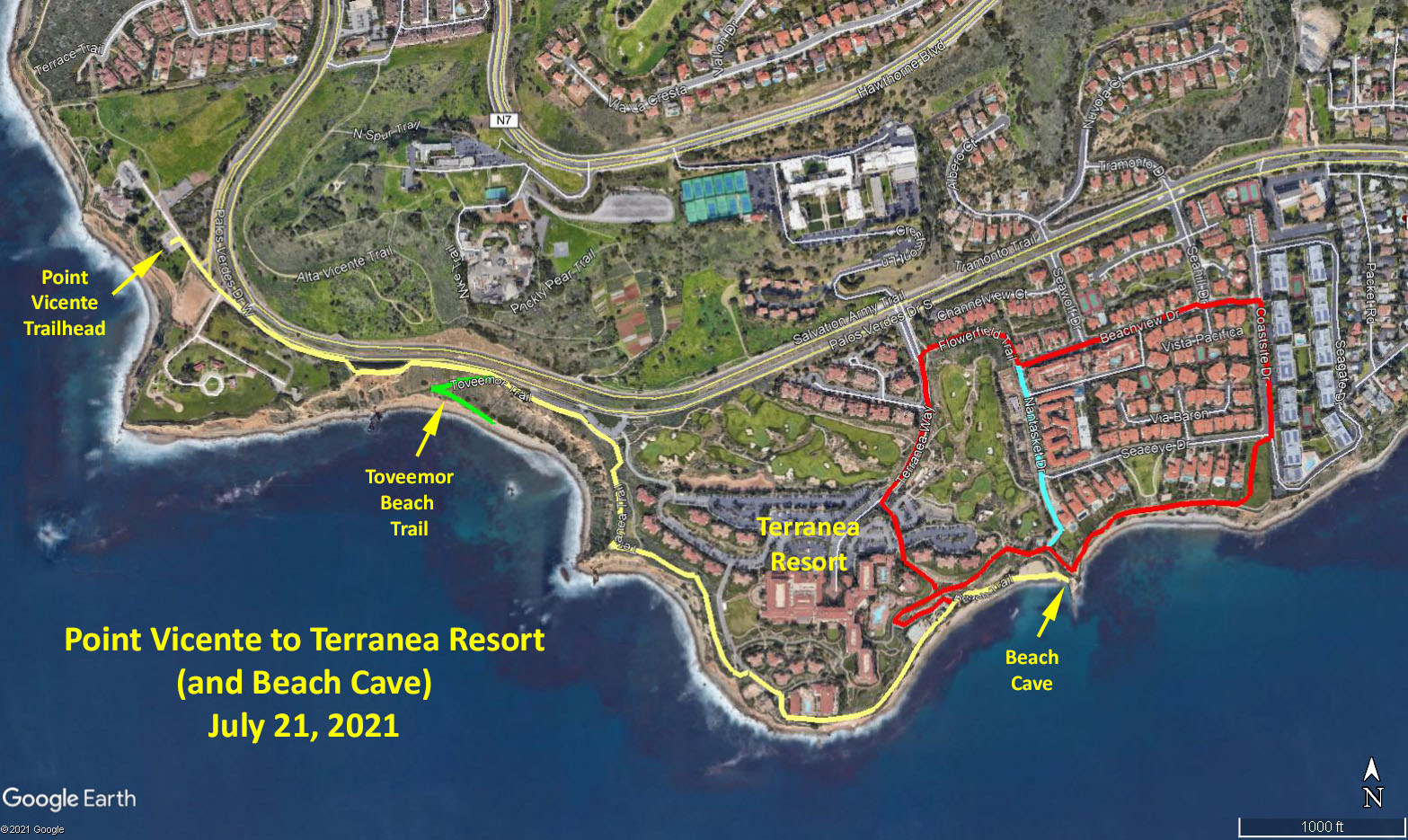
The Hike: Our hike will begin at the Point Vicente Interpretive Center. Head south-east out of the Interpretive Center onto Palos Verdes Drive West (Yellow track). After 0.5 miles take the Terranea Trail to the right that follows the coastline and passes though the southern edge of the Terranea Resort. Continue along the Beach Trail that ultimately ends at a rock outcropping at 1.33 miles from the trailhead. Scramble up the rocks to view the cave.
Those wishing a short hike can now retrace their steps back to the Interpretive Center for a total of 2.7 miles
Those wishing a longer hike can retrace their steps along the Beach Trail, before taking a hairpin right turn (Red Track) back onto the Terranea Trail, then onto the Vanderlip Park Trail. Turn left onto Coastsite Drive. Turn left onto Beachview Drive. Turn right on Flowerfield Trail. Turn right on Terranea Way. Turn left through the parking lot to rejoin Terranea Trail. The Red Track is a total of 1.5 miles. Those wishing to avoid the residential strreets can take the Nantasket Drive bypass (Light Blue Track for a total of 0.9 miles).
Head west to retrace your steps back toward the Point Vicente Trailhead.
Once back on the Palos Verdes Drive West, take a diversion to the beach on the Toveemor Trail (Green Track 0.3 miles RT). Retrace your steps back to the road and back to the trailhead.
Google Earth photo - Point Vicente to Terranea Resort
GPS Data:
Yellow Track: 2.7 miles RT
Yellow plus Red Tracks: 4.2 mles RT
Yellow plus Red plus Green Tracks: 4.5 miles RT
Minimal elevation gain
Updated: 2021-07-16