Hike #1423
October 2, 2019
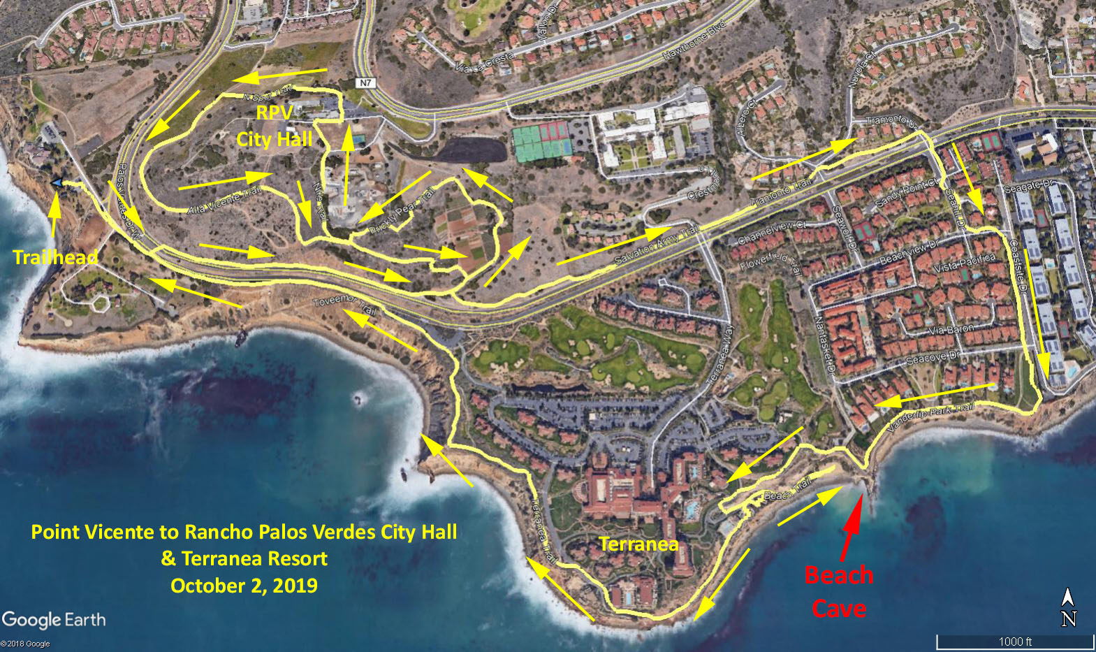
Point Vicente to Rancho Palos Verdes City Hall & Terranea Resort
Hike Leader: Vicky Ritter
Meet at 9:00 am for start at 9:30 am
Please print your own hike descriptions and maps. This will avoid the inconvenience and save costs to the hike leader.
Trailhead Directions: From the 405 Freeway take Hawthorne Boulevard South, up and over “The Hill” to the end of Hawthorne Blvd. at Palos Verdes Drive West. Turn left at the traffic light. (where you’ll find a “Starbucks” for coffee). Turn right at the next turn off, which will be the entrance to Point Vicente Interpretive Center, and park in the parking lot. This small natural history museum is an ideal whale-watching spot. Exhibits highlight the peninsula's geology, flora and fauna. There are restrooms available at the park, after 9 am and at Terranea Resort.
If you take the 110 Freeway, go South to the Pacific Coast Hwy off-ramp and head West. Turn left when you come to Hawthorne Blvd. and follow the directions listed above.
The Hike: This is a 4.7-mile loop with about 400 feet of elevation gain on trails around Rancho Palos Verdes City Hall and continues down and around Terranea Resort. The hike starts on a trail adjacent to PV Drive then crosses the two lanes of traffic where the northbound lane enters the parking lot. There is no traffic light here and the traffic moves fast so be very cautious. Continue on the trail along PV Drive 0.3 mile until reaching a gated access road on the left. Go up this to enter the Alta Vicente Reserve. In the Reserve the route will be the Prickly Pear Trail, the Alta Vicente Trail, the Nike Trail, the access roads of the City Hall, the North Spur Trail and the Alta Vicente Trail. The route then continues on the Salvation Army Trail to the traffic light where we cross PV Drive and go down Terranea Way a short distance to the Flowerfield Trail. Head down this trail to the Terranea Trail where we turn right and continue to the Beach Trail. Go down to see the cave and beach and come back to the Terranea Trail. Take this trail all the way around Terranea Resort and back to PV Drive and then the trail next to the road to the Interpretive Center.
It is 3.3 miles if you skip the Terranea loop and return on the trail along PV Drive after the traffic light.
A short 2.5 mile scenic hike starts as above but in the Alta Vicente Reserve skip the Nike Trail and continue on the Alta Vicente Trail to the paved access road. Walk down this road to PV Drive, turn right and walk to the Traffic light. Cross PV Drive and head down Via Vicente, which is the extension of Hawthorne Blvd. Turn left at Calle Viento then right at Pacifica Del Mar then take the Terrace Trail at the dead end to the Bluff Trail. Turn left and head to the Interpretive Center.
Google Earth photo - Point Vicente to RPV City Hall & Terranea
2019-09-02