Hike #1358
Chantry Flat - Various Destinations
April 11, 2018
Hike Leader: Wendell Suzuki
Meet at 9:00 am for start at 9:30 am
Please print your own hike descriptions and maps. This will avoid the inconvenience and save costs to the hike leader.
Directions to Trailhead: Take the 210 Freeway east and exit on Santa Anita Ave. in Arcadia. Head north on Santa Anita Ave. which eventually turns into Chantry Flat Road. Drive to Chantry Flat in about 5-6 miles. Park in the upper large lot. Signed trailhead is across the road. Don't forget Forestry parking pass.
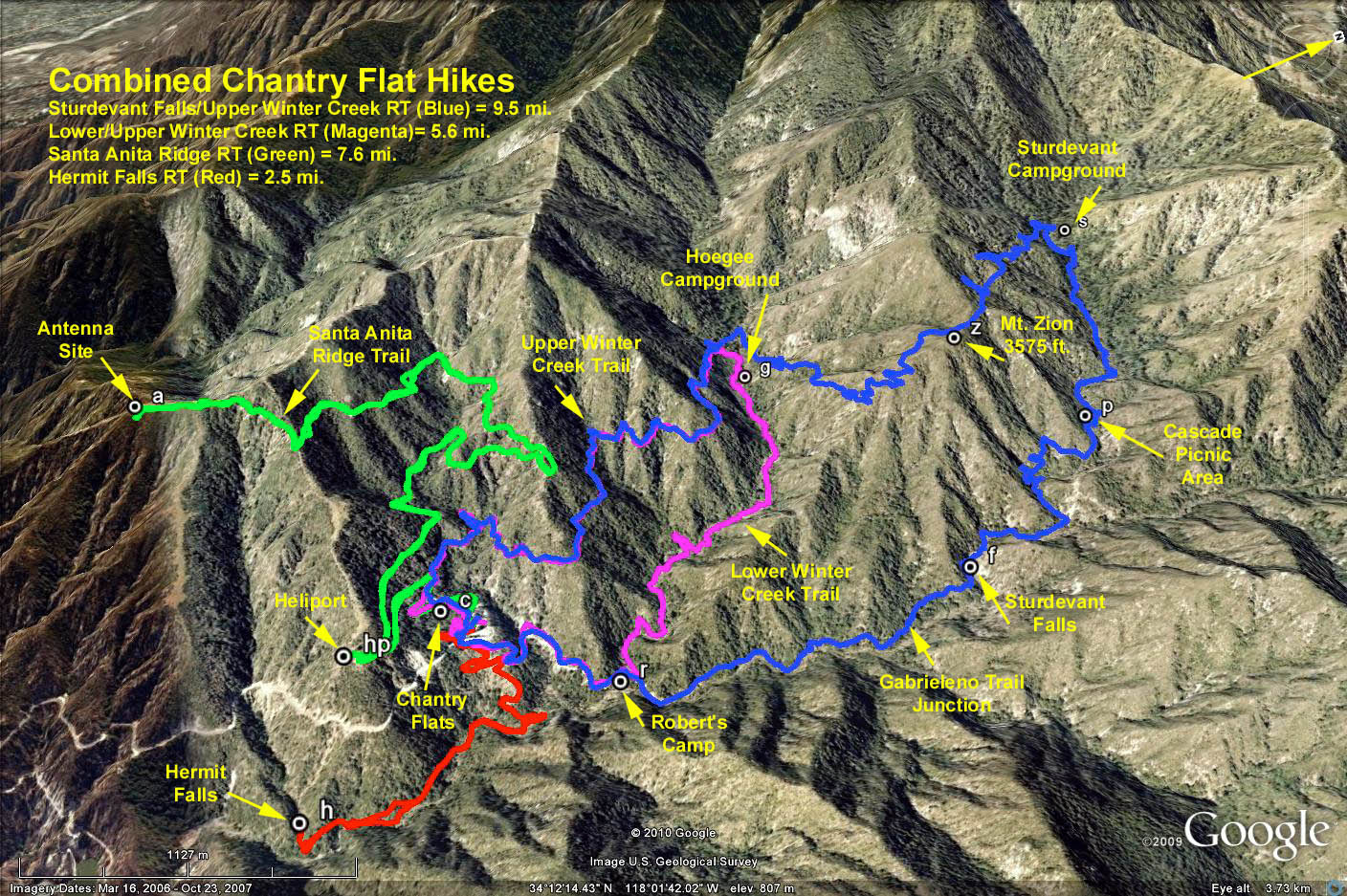
Hike Options: There are many hike choices from this trailhead:
Option 1: It could be an out and back to one of the camps along Gabrielino Trail and return. Example: Return from Spruce Grove = 7 miles round trip. Or, turn around sooner.
Option 2: It could be a longer loop trip up to Sturdevant Campground then onto Mount Zion and return via Upper or Lower Winter Creek trails, 8-9 miles.
Option 3: It could be a shorter loop from Roberts Camp along Lower Winter Creek to Hoegees and return via Upper Winter Creek. 5.1 miles
Option 4: It could be a long out and back on the Santa Anita Ridge Trail (7-8 miles), or even a longer 9 mile trek extending from the ridge along the Olene Ridge and back via Upper Winter Creek.
Option 5: Or it could be a shorter descent to Hermit Falls starting from the "First Water" trail turnoff, 3 miles.
Weather and altitude thoughts: Chantry = 2,220 feet, Mt. Zion = 3,575 feet, Spruce Grove = 3,100 feet, Hoegees = 2,500 feet, Sturtevant = 3,240 feet. Hopefully all below snow level, but wouldnt it be nice to see some?
GPS Data: Note: Chantry Flat Trailhead Elevation = 2200 ft.
Lower/lower Winter Creek to Hoegee Campground (Magenta-Blue)
Total miles = 5.6 mi. RT
Helipad add on = 0.8 mi. RT
Max Elevation change = +660 ft.
Hermit Falls (Red)
Total miles = 2.5 mi. RT
Max Elevation Change = - 645 ft.
Gabrielino Trail to Sturdevant Camp, Mt. Zion, Upper Winter Creek (Blue)
Total miles = 9.5 mi. RT
Base of Sturdevant Falls add on = 0.6 mi. RT
Max Elevation Change = +1750 ft.
Santa Anita Ridge Trail (Green)
Total miles = 7.6 mi. RT
Max Elevation Change = +1600 ft.
Santa Anita Ridge-Olene Ridge-Upper Winter Creek (Green-Yellow-Blue)
Total miles = 9.2 mi. RT
Max Elevation Change = +1870 ft.
Google Earth photo - Combined Chantry Flats Hikes
2018-03-20