Hike #1357
Colby Canyon and Josephine Peak
April 4, 2018
Hike Leader: Jim Spotts
Meet at 9:00 am for start at 9:30 am
Please print your own hike descriptions and maps. This will avoid the inconvenience and save costs to the hike leader.
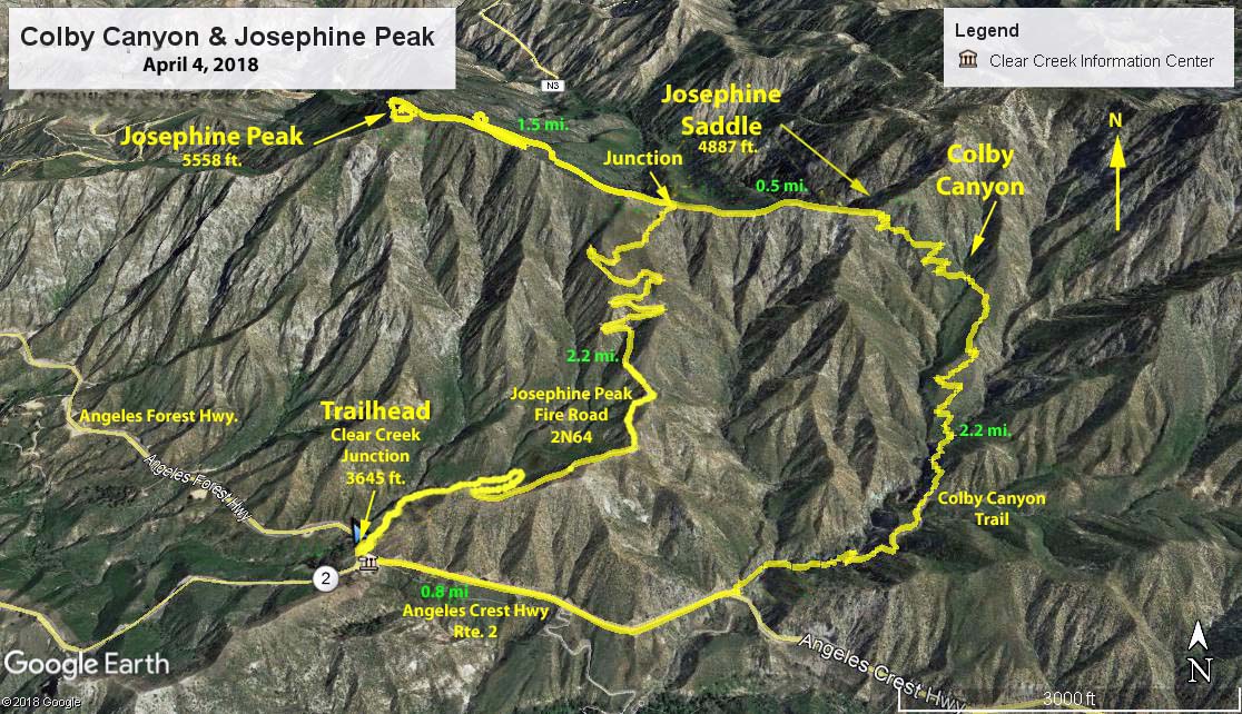
Directions to Trailhead: Take Angeles Crest Highway 2 to Clear Creek Junction (the junction of Angeles Crest with Angeles Forest Highway - N3) and and park on the left side of Angeles Forest Highway just past the corner of it and Angeles Crest Hwy.
The Hike: You can begin this hike by going up the Josephine fire road across from our parking area near Clear Creek Junction. There are four options:
Option 1. Turn around at the Junction (1250 ft. climb) and return the way you came for 4.8 miles RT.
Option 2. Turn right at the Junction (1250 ft. climb) and go along the Josephine Saddle, then down the Colby Canyon trail to the highway at the Colby Canyon trailhead, turn right and walk back on the highway to the trailhead for 5.9 mi RT.
Option 3. Turn left at the Junction, go up to Josephine Peak (2080 ft. total climb from trailhead) and return the way you came for 7.8 miles RT.
Option 4. Same as 3 except continue past the Junction along Josephine Saddle, then down the Colby Canyon trail to the highway at the Colby Canyon trailhead, turn right and walk back to the trailhead for 8.9 miles RT.
There is one toilet at the Clear Creek ranger station and at least one more at the top of the road down to Switzers (0.5 mi. east on the hwy.).
Refreshment will be by the cars.
Google Earth photo - Colby Canyon & Josephine Peak
2019-09-27