Hike #1356
March 28, 2018
Vasquez Rocks - Pacific Crest Trail
Hike Leader: Dan Bergstrom
Meet at 9:00 am for start at 9:30 am
Please print your own hike descriptions and maps. This will avoid the inconvenience and save costs to the hike leader.
GPS Data:
Loop around the park = 3.4 mi.
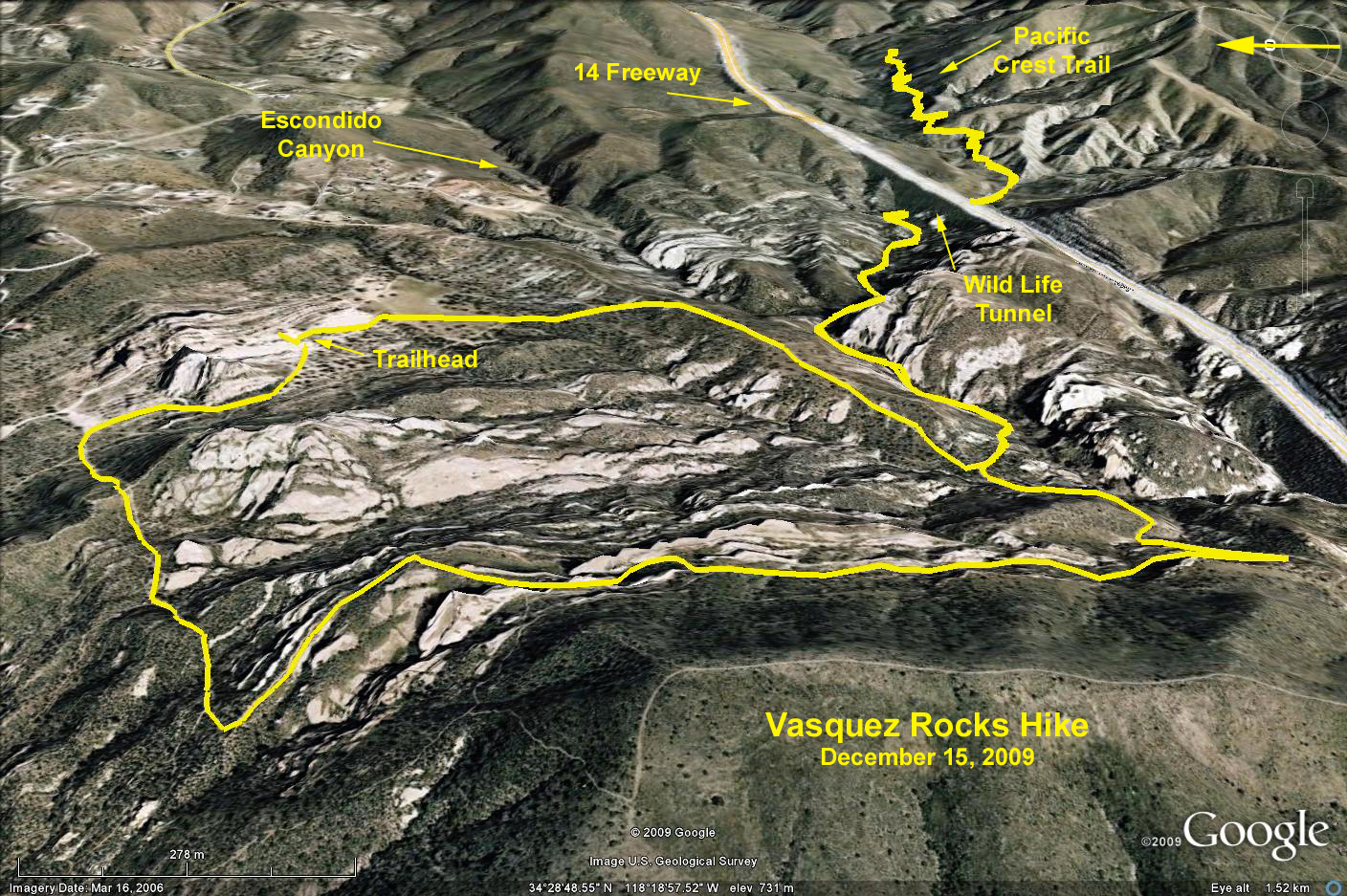
PCT Extension = 4.9 mi. RT
Elevation gain = 350 ft.
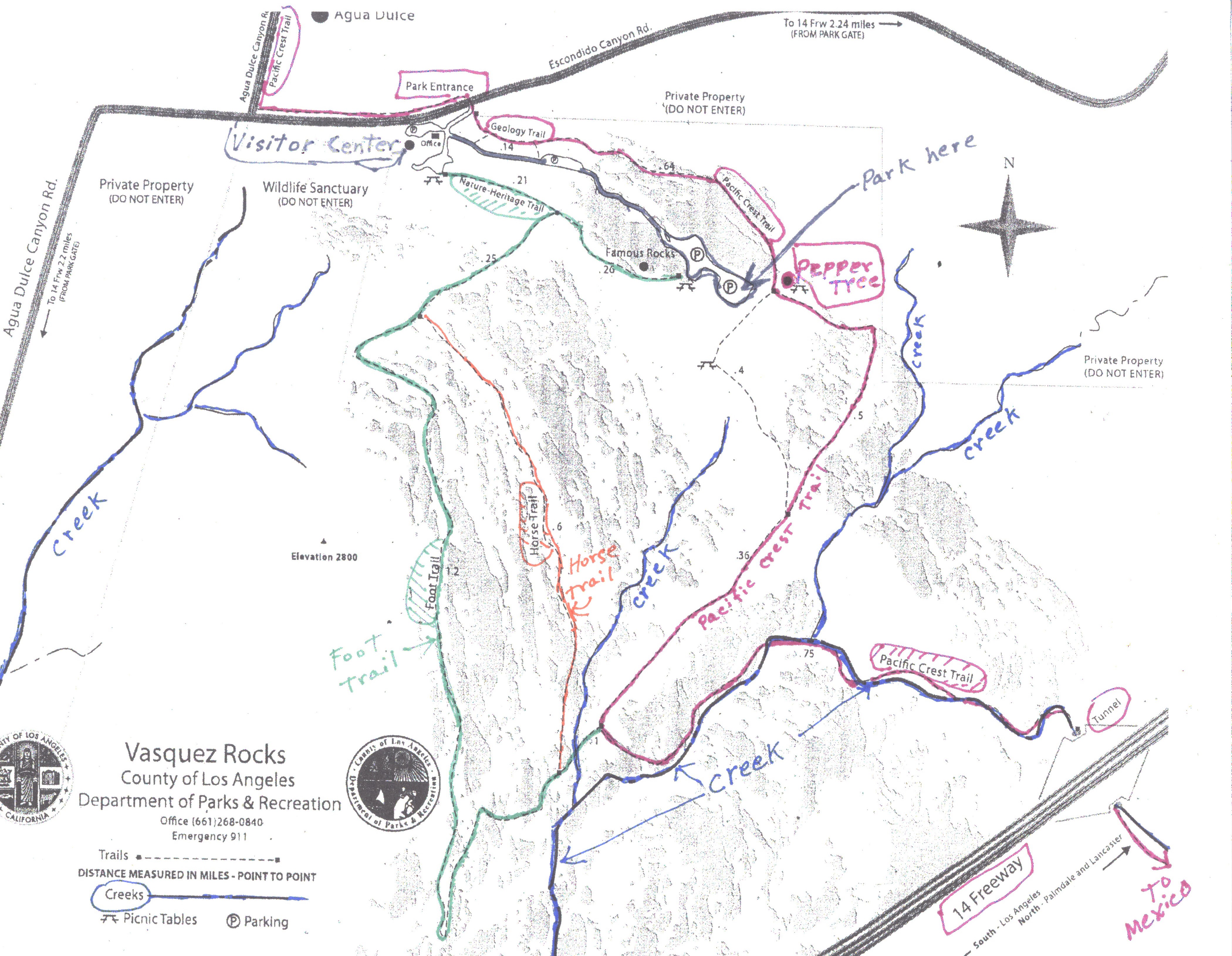
Directions to trailhead: Take the 14 Freeway toward Lancaster. Exit the 14 freeway at Aqua Dulce Canyon Rd. Turn left (north) toward Aqua Dulce. Just short of Aqua Dulce, the road takes a sharp right and continues for 0.25 miles. At the stop sign, it turns north again, but keep going east on Escondido Canyon Rd for 0.35 miles. Do not go into the town. The park entrance will be on the right. The park address is 10700 W. Escondido Canyon Rd., Aqua Dulce, CA 91350.
The Visitor Center will be on the right as you enter the park. Modern clean restrooms are available here as well as maps and other information about the park. Many portable restrooms are also available in the other parking lots.
The hike begins and refreshments will be served at the Pepper Tree. From the park entrance, turn left and drive to the southeastern most part of the second parking lot (about 0.6 miles).
The Hike: We will begin the hike heading southeast, then southwest from the Pepper Tree on the Pacific Crest Trail. After about 0.85 miles, the PCT takes a sharp left turn and heads southeast to the tunnel under the 14 Freeway (0.75 miles). Those desiring a longer hike can continue on the PCT and then backtrack. The loop hike continues on the Foot Trail to the right and downhill past the Horse Trail for about 0.2 miles, then makes a hairpin turn and heads straight north for 1.2 miles. It then turns right and heads northeast, where it intersects the Nature-Heritage Trail. Turn left to explore the Visitor Center, then either backtrack the Nature-Heritage Trail to the Pepper Tree, or go east across the road and return via the Geology Trail and the PCT.
While it seems simple enough on paper, in reality there are so many uncharted crisscrossing trails off of the Foot Trail that it will be almost impossible to stay on the trail as described. Getting lost should not be a problem however because the park is small (about 1.5 square miles) and either the parking lot or the Visitor Center will be visible from almost anywhere.
Alternative Hike: Those wanting a shorter hike can backtrack from the Pepper Tree to the Visitor Center via the PCT and Geology Trail and return on the Nature-Heritage Trail.
The hike is relatively short so there will be plenty of time to do some rock climbing and explore this very unique geological wonder.
Google Earth Photo - Vasquez Rocks - PCT Extension
2018-03-20