Hike #1351
Calabasas Peak from Red Rock Canyon Park
February 7, 2018
Hike Leader, Norm Maclean
Meet at 9:00 am for start at 9:30 am
Please print your own hike descriptions and maps. This will avoid the inconvenience and save costs to the hike leader.
GPS Data:
Main Hike: 5.1 mi RT with 1128 ft. elevation gain.
Short Hike: 2.6 mi RT with 565 ft. elevation gain.
Main Hike Extension: Adds 1 mile RT.
Directions to Trailhead: Please CAR POOL since there is LIMITED PARKING. Get on Topanga Canyon Blvd. from the Valley or the coast and drive to its intersection with Old Topanga Canyon Road, then drive west 1.8 miles to Red Rock Rd. Turn left on Red Rock Rd. After 0.3 miles the paving turns to dirt. After 0.3 more miles you get to the park boundary where you find the first iron ranger. Drive another 0.2 miles up a narrow canyon to the trailhead parking lot where there is another iron ranger, picnic tables, a pit toilet, and parking for 8 or 9 cars. The Santa Monica Mountains Conservancy charges $5.00 to park. The address is Red Rock Canyon Park, 23601 West Red Rock Road, Topanga.
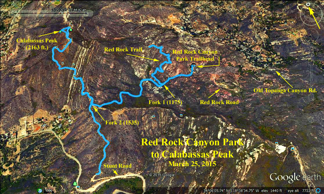
Please print out the Red Rock Trail Map in order to understand the hike options.
Hike Options: The trailhead (1060) is at the P on the map. Stunt Road is where the Calabasas Peak Trail ends on the south. The Viewpoint (1500 ft.) is at the end of the Red Rock Trail. Fork one is at (1175 ft.) and fork two at (1535 ft.).
Main Hike: Calabasas Peak. From the trailhead go past fork one (1175 ft.) to fork two (1535 ft.) then north and up to Calabasas Peak (2163 ft.).
Short Hike: Viewpoint. From the trailhead go to the first fork (1175 ft.) turn north and hike to the top of the ridge (1500 ft.) for a good view.
Main Hike Extension: Stunt Road. On the return from Calabasas Peak, continue south on past fork two (1535 ft.) to Stunt Road. Return to the trailhead via fork two (1535 ft.), then east via fork one (1175 ft.).
Google Earth Photo - Calabasas Peak from Red Rock Canyon Park
2018-01-31