Hike #1331
August 9, 2017
Chilao to Horse Flats and Mt. Hillyer
Hike Leader: Sam Prum
Meet at 9:00 am for start at 9:30 am
GPS Data:
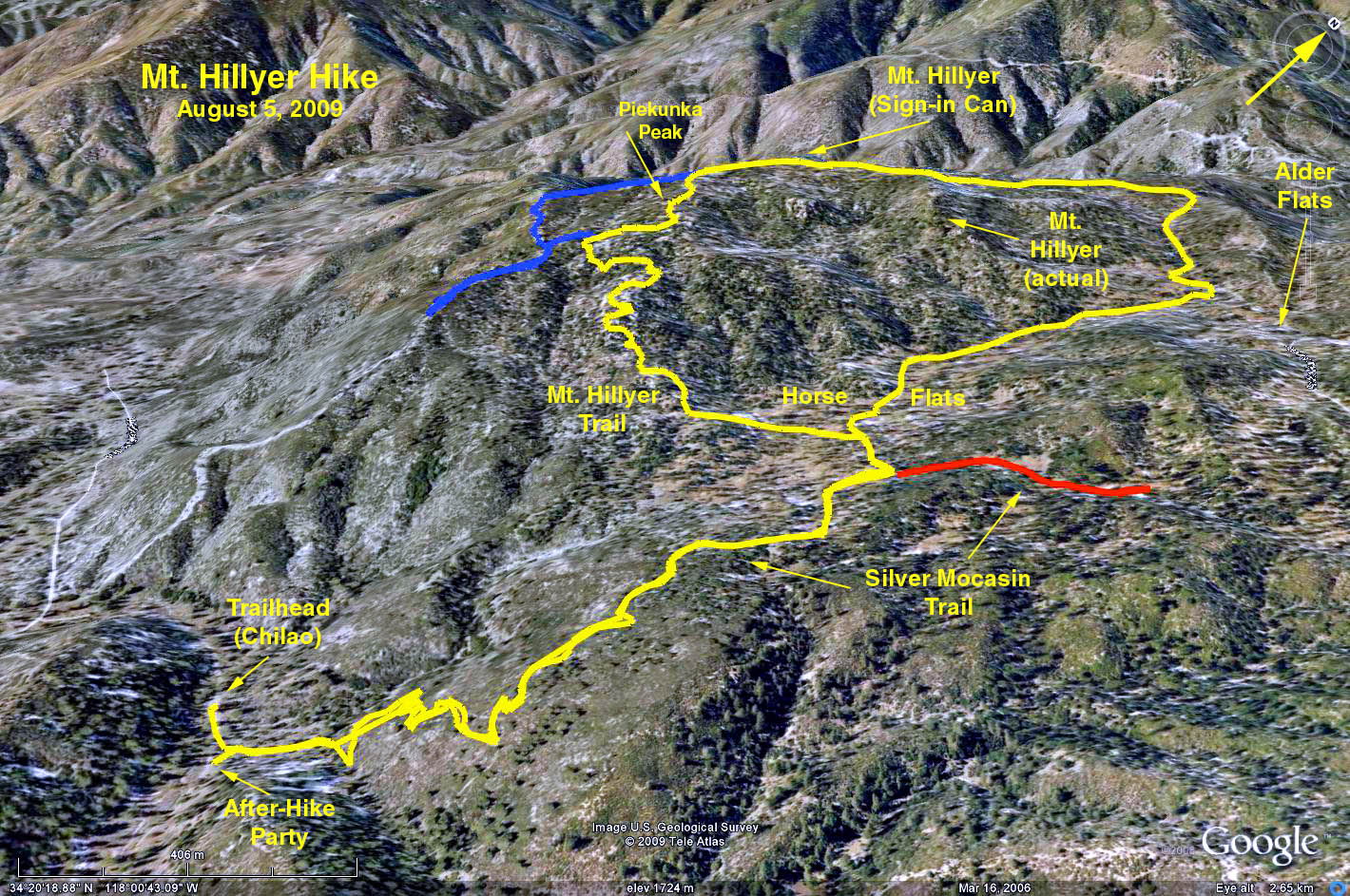
Chilao Picnic Area to Mt. Hillyer Summit
Basic Hike is 6.4 miles RT; max. elev =1,000 ft.
Alternate Loop RT = 5.7 mi.
Trailhead Directions: Drive north on SR-2 (Angeles Crest Hwy.) to mileage paddle 50.60. Turn left toward the Chilao Visitor Center. This is about a mile past the Chilao Campground turn-off. Continue straight 0.4 miles, passing the Visitor Center, to the “Upper Chilao Picnic Area” sign (post marker 3N21D). Park in the picnic area spaces or neighboring areas. There are restrooms at the Picnic Area.
General Description: Rising to just over 6,200 feet, Mount Hillyer is actually one of the easier summits to reach in the high country of the San Gabriel Mountains. Beyond its boulder piles and pine forests, the stretched-out summit offers several sweeping views of nearby peaks and canyons. You can also hike a mile along the summit to pursue all the views.
The Hike: We walk 0.3 miles further along the road we arrived, to reach the Silver Moccasin Trail. We start hiking north on the Silver Moccasin Trail using switchbacks to gain a slope covered with pines and chaparral. At 1.1 mi. and the edge of Horse Flats Campground we turn left and follow a path about 0.1 miles to the Mount Hillyer trailhead and a sign indicating 2 miles to the summit (the summit is actually 1.7 miles away!). Proceed up the trail past clusters of Manzanita, scrub oak and Jeffrey pine to a complex of very large boulders. The trail breaks out of the forest onto a firebreak, and before you realize it, you’ve reached the 6,215-foot summit. It is hard to tell when you’ve arrived because the highpoint does not distinguish itself by rising far above the rest of the mountain. Instead, there is a long ridge running across Mount Hillyer that crowns the long summit.
A side hike of about 0.3 miles southwest along the summit ridge onto a firebreak yields a better viewpoint, or you can hike further along the summit ridge (1 mile RT). Return the way you came.
Alternative Loop Return: If you continue down the road past the summit, the fire road narrows to a trail which descends steeply down to the paved Horse Flats Campground turnoff road (distance from the summit 0.5 mi). We now turn right and follow this road 0.7 mile to where we left the Silver Moccasin Trail. We then retrace our steps 1.1 miles down the Silver Moccasin to our cars.
Other Information: Refreshments will be served at the Picnic Area.
Google Earth - Chilao to Mt. Hillyer
https://www.hikespeak.com/trails/mount-hillyer-hike/
2017-08-08