John Fasheh, Hike Leader
GPS Data:
Basic Hike (Blue Trace) RT = 6.4 mi., Elevation gain = 1,150 ft.
One option (Yellow Trace) RT = 7.2 mi., Elevation Gain = 1,300 ft.
Directions to Trailhead: For those in the Valley area, take Victory Blvd. westbound to the trailhead.
For those traveling from the south, take the northbound Ventura (101) Fwy., exit Valley Circle Blvd. Turn right (north) and go approximately 2 miles to Victory Blvd. Turn left and go approximately 1 mile to the trailhead.
Parking fee is $3.00 per vehicle. Alternatively, park on Victory Blvd. and walk up to the trailhead. Restroom facility consists of one Andy Gump.
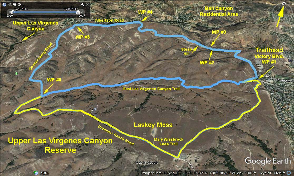
Summary: We hike north from the trailhead towards Bell Canyon and then west to make a counter clockwise loop. We climb up in elevation and have beautiful views of the valley, Bell Canyon and the surrounding mountains. About half of the trail is not shown on maps but they can be seen on Google Earth type displays. There are many trails and one has to follow the right one to make the loop. Therefore, it is recommended that those with GPS devices download the Las Virgenes Preserve gpx file, transfer the gpx file to your GPS device. Alternatively, hikers can follow the critical waypoints given below on their device. It is recommended that other hikers then follow those hikers so equipped.
The Hike: Start north on the road leading out of the trailhead. Turn left at the intersection of another road coming in from the right. Turn right at a use trail leading north from the road (WP #2). After only a dozen yards turn left on another use trail leading off to the left (WP #3) and headed towards a steep hill. Climb the series of hills on obvious trails to WP #4. Turn left and proceed along Albertson Road until reaching a Conservancy sign indicating Conservancy Road (WP #5). Bear left and continue down this trail to WP #6. Turn left and take the East Las VirgenesCanyon trail back to the trailhead.
Options: A number of options are open beyond WP #6 leading to Laskey Meadow and additional mileage. See yellow trace.
Refreshments will be at the trailhead.
Google Earth photo Las Virgenes Preserve Northern Loop
On line information: Upper Las Virgenes Canyon
GPS Critical Waypoints:
WP #1. Victory Blvd. Trailhead = N34 11.124 W118 40.113
WP #2. Trail Junction - turn right = N34 11.62 W118 40.45
WP #3. Trail Junction - turn left then up steep slope = N34 11.644 W118 40.474
WP #4. Albertson Rd. Junction - bear left = N34 11.910 W118 41.279
WP #5. Conservancy Rd. Junction - turn left = N34 11.737 W118 41.974
WP #6. Trail Junction = N34 10.740 W118 41.783
2017-06-03