Hike #1318
Griffith Park North Loop - Shuttle
May 10, 2017
Jim Carlin, Hike Leader
Distance: RT 5.7 miles
Elevation Gain: 1258 ft.
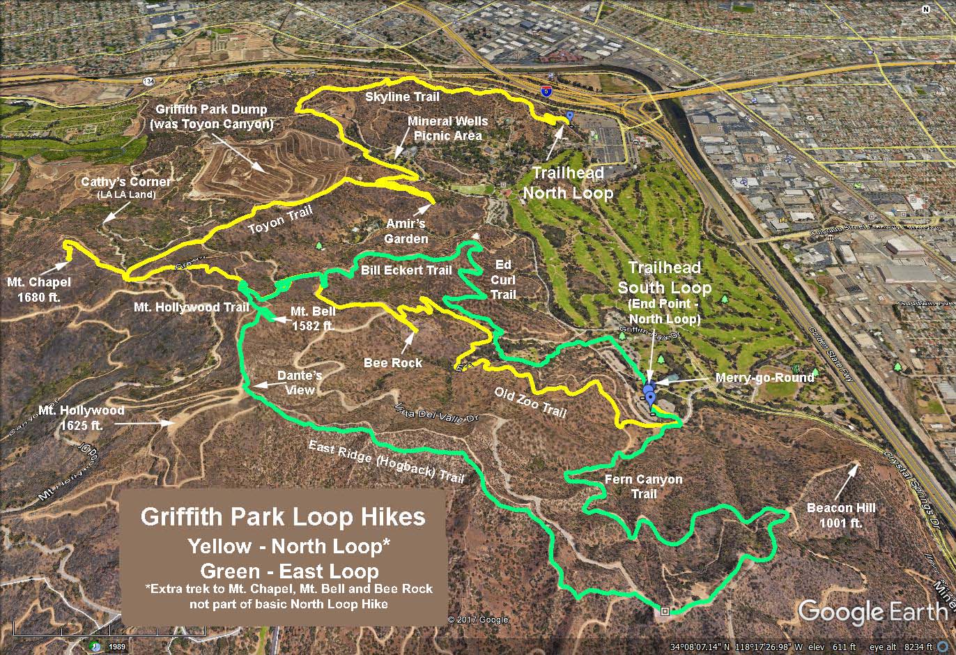
A map is attached with the routes and landmarks {} indicated (Green map trace).
Introduction: This hike takes us to the higher, northern parts of Griffith Park. The hike combines several of the parks trails (cited in bold) in a counter-clockwise loop, taking us past the LA Zoo, Amirs Garden and the Old Zoo area. To eliminate a long boring walk along the Crystal Springs bridal path, a shuttle will be attempted where hikers will be transported to the trailhead leaving at least one car at the meeting place (Merry-Go-Round upper lot). The hike ends there, refreshments will be served at picnic tables nearby, then drivers who left their cars at the trailhead will be driven back to their cars.
Directions to Meeting Place: We will meet at the Griffith Park Merry-Go-Round upper lot. From I-5 north take Griffith Park exit, turn right on Crystal Springs Drive then left at the Merry-Go-Round sign. From I-5 south take the Los Feliz west exit, turn right on Los Feliz, turn right on Crystal Springs Drive then left at the Merry-Go-Round sign. Restrooms are available nearby.
The Hike: (Green map trace) We proceed onto the bridal trail which heads north and west crossing a paved road and entering the signed Skyline Trail trailhead just across the road. The dirt trail leads steeply up and to our right climbing above the back of the zoo on our left and the freeway junction below to our right. At the first T intersection we come to, we bear hard right past the Condor trail which branches off to the left. At the next fork (now about about 2 miles from the trailhead) we continue straight ahead, on the Rattlesnake Trail which comes in on our left. We bear left at the next 4-way intersection {38} of the Skyline and Rattlesnake trails and descend a ¼ mile to paved Griffith Park Drive.
Cross Griffith Park Drive {36} bear left through a white painted gate with red stripes following the signs to the Mineral Wells Picnic Area {26}. You are now on the Mineral Wells Trail. The Mineral Wells Picnic Area is triangular in shape caused by Griffith Park Dr. splitting at the north end, then joining again at the south end. There is a small grotto with picnic tables on entry and this is a great place to have a cookie break. There is a restroom building down and across the grassy area adjacent to the eastern leg of Griffith Park Dr.
Leave the picnic area by continuing on the trail we entered on, and look for a T intersection {24} with signed directions to Amir's Garden (See reduced mileage blue option 1). Turn right at the T and ascend a steep ½ mile to Amirs Garden. Out of respect for Amir Dailameh, who starting in 1971 spent 32 years transforming the 5 acre site into a public garden, please take the time to explore his garden.
Leave Amirs garden by continuing on the trail (which basically makes a "U" turn by-passing the garden area), climbing again for another ½ mile (neglect all side trails) to a crossing of paved Vista del Valle {18} (See La La Land yellow Option 2). Cross Vista del Valle and pick up the trail again bypassing another trail coming in from the right {41}. This route takes you up high on the ridge {39} (See increased mileage red Option 3), ultimately returning to Vista del Valle {16} (Note: If you are sick of climbing at this point, just continue on the road). After a couple of hundred yards, look for the signed entrance to the Eckert Trail {14} and bear left.
We begin a long looping descent on the Eckert Trail (bypassing a side trail mid-way coming up from the left) ultimately bringing us to a major trail junction with the Ed Curl Trail {12}, the trail up to Bee Rock {10} (well worth the diversion if you have the time), and the Old Zoo Trail. Follow the Old Zoo Trail {10} past the old cages and grottos of the Old Zoo until it ultimately ends on the paved road leading to the Merry-Go- Round upper lot, refreshments, restrooms, etc.
There are three rest areas suitable for cookies or lunch: Mineral Wells Picnic Area, Amir's Garden, or the Old Zoo Picnic Area. Choice of which area to use depends on timing, and hiker's preference.
Option 1 (Reduced mileage - blue map trace) Instead of going to Amirs Garden, at the junction {24} continue straight ahead on the Mineral Springs Trail eventually crossing the road to the Boys camp and picking up the Ed Curl Trail. Take it to the major trail junction {12}, look for signs and follow the Old Zoo Trail {10} past the old cages and grottos of the Old Zoo until it ultimately ends on the paved road leading to the Merry-Go-Round upper lot.
Option 2: (The La La Land option - yellow map trace) Instead of crossing Vista del Valle, turn right and follow the road to the west out and around the loop to "Cathy's Corner" (see map) which is where the La La Land couple did their dance. Return the way you came.
Option 3: (Increased mileage - red map trace) The trail denoted on the map by {18} {41} (39} is the Mt. Hollywood Trail. Take it south as far as you wish visiting Captain's Roost, Dante's View and Mt. Hollywood. Return the way you came descending to Vista del Valle and the Eckert Trail or else get creative (please let us know your intent via radio).
Alternate hike suggestion: Visit the Museum instead. Museum web site. Free restrooms located to the right of the bronze statue within the entry patio. Entry to the patio does not require paying an admission fee.
Refreshments served near the Meeting Place.
Please bring printouts of the above description and the map Griffith Park Hike Map (in color) with you to the hike.
Hiking by Numbers (See Map): Skyline-38-36-26-24-Amir-22-20-18-41-39-16-14-Eckert-12-10-Old Zoo-Merry-Go-Round
Google Earth - Griffith Park Combined A. North loop is the yellow track.
2017-07-22