Hike #1291
Point Vicente to Hesse Park & Return
September 14, 2016
Larry Savell, Hike Leader
GPS Data:
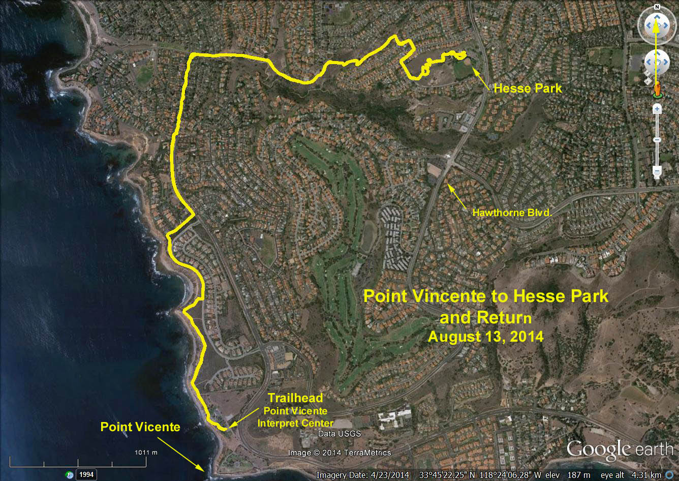
RT = 7.8 mi.
Max Elevation Change = 870 ft.
Introduction: Our hike will begin at the Point Vicente Interpretive Center. Located next to Point Vicente Lighthouse, this small natural history museum is an ideal whale-watching spot. The many exhibits highlight the Palos Verdes peninsula?s geology, flora and fauna. Side trips are also possible for the more adventurous.
Trailhead Directions: From the 405 Freeway take Hawthorne Boulevard SOUTH, up and over The Hill to the end of Hawthorne Blvd. at Palos Verdes Drive West. TURN LEFT at the traffic light, (where you will find a Starbucks for coffee). Turn right at the next turn off, which will be the entrance to Point Vicente Interpretive Center, and park in the parking lot.
If you take the 110 Freeway go South to the Pacific Coast Hwy off-ramp and head West. Turn left when you come to Hawthorne Blvd. and follow the directions listed above.
If you want to be dropped off at Hesse Park the entrance is just past Verde Ridge Road on the right as you travel south on Hawthorne Blvd. Note: There are restrooms available at Point Vicente and at Hesse Park, after 9 AM.
The Hike: The hike will take us along the coastal cliffs of Palos Verdes in the city of Palos Verdes Estates. If the weather cooperates, the shoreline and ocean views are magnificent and we might be able to get a great view of Catalina Island and Malibu. We will follow a path that takes us to Palos Verdes Drive West where we will cross to the center median where there is a walking/running path. We continue hiking until we come to Paseo Luando, where we Turn right for one block where we run into the trail that will take us up the hill to Hesse Park. There is a short section of the hill that is quite steep but otherwise very manageable.
The trail ends between two homes and comes out on Kings Harbor Drive where we make a right turn and follow it down, around, to the left and up to Verde Ridge Road. There are a couple of alternative streets you can try as well that will end up in the same place. We continue up to Locklenna Lane where we make a right and continue across the street to the park where there are a couple of different paths to the top of the park. This would be a great place to have lunch and admire the view.
Alternate hikes: If you want to only go downhill, you can start your hike at Hesse Park and just hike downhill either on the Hesse Park trail or down Hawthorne Blvd. until you reach the Point Vicente Interpretive Center. That would only be about 3.5 miles. You can also start at the Point Vicente Interpretive Center and go as far or near along the paths as you like and turn back anywhere.
Refreshments served at Point Vicente Interpretive Center.