Distance: 6.0 mi. RT
Cumulative elevation gain/loss: 960 ft.
See below for important GPS coordinates.
Overview: The hike follows the east ridge of Rustic Canyon, opposite the ridge bounding Will Roger's Estate. The hike passes by Boy Scout Camp Josepho, an old barn still standing from the ranching days, the now cleared foundations of the Murphy Ranch buldings, and the generator building, now closed off, and well decorated in graffiti. The ranch was used by an isolationist German group during World War II. After the war, the property morphed into a utopian artist's colony. Perhaps the most amazing hike feature are the hidden stairways that apparently served the canyon ranchers attending their crops and orchards planted on the steep hillsides. There are three stairways - we will climb only two of them.
Directions to Trailhead: From PCH take Sunset east 0.7 mile PAST Will Roger's Ranch entry road to Amalfi Dr. There is a traffic light at Sunset and Amalfi Dr. Go north (left) on Amalfi approximately 1 mile always taking the left option at Pavia and Sorrento Streets. Amalfi Dr. crosses Capri Dr. at a wide intersection. Park on the street at this intersection, being careful to observe No Parking signs. From the 405 freeway, go west on Sunset 5.5 miles to Amalfi Dr., turn right and proceed per above to the intersection with Capri Dr.
The Hike: Follow Capri Dr. north a short distance to a "T" intersection with Casale Road. Turn left and proceed uphill on Casale Road on which many large houses are being constructed, and which soon turns to a paved fire road. After about 0.2 mile, we will come to a yellow gate across the Sullivan Fire Road providing entry to the Rustic Canyon State Park. We follow this road for 2.4 miles. (CAUTION: Along the road we pass two chain-link fenced areas on the left which are the tops of stairway #3 and then #2 - our return paths, and a new large opening off to the left with a sign and trail to Murphy Ranch - we bypass all of these). After 2.4 miles on the Sullivan Fire Road we reach a fork. On the right a yellow gate across the fire road and to the left, an overhead gateway welcoming you to Camp Josepho. Take the left fork, under the sign and hike down 0.6 miles to Camp Josepho.
Just before the camp entrance, now across the stream bed, we turn left onto a trail paralleling the stream and passing the Camp buildings on our right. Eventually we come to and take an obvious stream crossing on our right. Afterwards, proceed to and through a rudimentary camp ground and look on your right for a pistol firing range and a yellow sign on a post: "CAUTION, firearms used in this area." Take the trail to the left of this sign which heads in a southerly direction back down the canyon. Eventually the trail forks at some heavily graffitied stone walls. Take the right fork (now a roadway).
After about 1 mile past Camp Josepho, we come to a sign on a pole indicating the direction to Will Rogers (this is the Backbone Trail intersection). Continue straight ahead per the sign and note a large old barn enclosed in a chain link fence on our left. Stop and take in the graffiti. Continuing on for another 0.3 mile we come to a large clearing with a concrete floor and a much graffitied retaining wall in the rear. This is the site of the Murphy Ranch (they have cleared the rusted remains of the old buildings). This is a good lunch spot. Do not take the crumbling stairway just beyond the clearing on the right.
Continue along the road some 500 ft., just past the much graffitied generator building, to the bottom of stairway #1 which leads 47 steps up to a small patio, then continues on up the canyon wall for an additional 130 steps. At its top, we come to another part of the ranch road where we turn right and walk about 300 ft. until we see a much-traveled opening in the brush and the bottom of stairway #2 on the left. This stairway is lined mostly by a railing and climbs 321 steps to an old water tank. Walk around the tank and proceed up an additional 40 steps to the Sullivan Fire Road we were on before. Turn right on the road, and continue back to the trailhead.
Perhaps a more historic alternative choice is to continue past the bottom of stairway #2, about 400 ft., to the beginning of a small trail on the left which leads to the bottom of stairway #3, the longest known continuous stairway in Los Angeles. It numbers some 512 steps and has no railings. It leads up to the Sullivan Fire Road, where a right turn will get you back on the way to the trailhead.
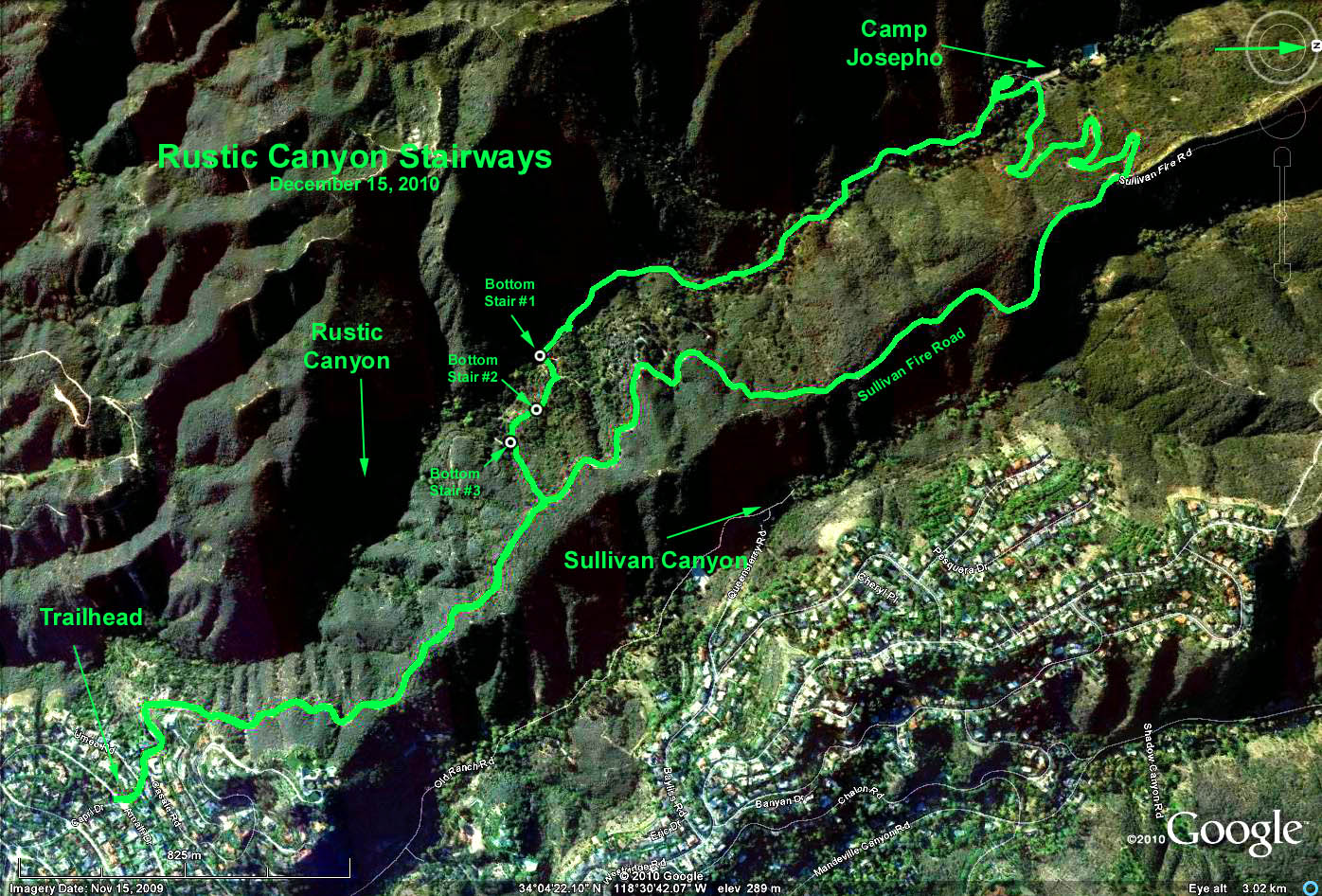
Google Earth photo - Rustic Canyon Stairways Note that we are looking WEST in the photo.
Important GPS coordinates:
Trailhead: N34 03.611 W118 30.175
Camp Josepho: N34 04.884 W118 31.236
Bottom of Stairway #1: N34 04.211 W118 30.863
Bottom of Stairway #2 N34 04.204 W118 30.775
Bottom of Stairway #3 N34 04.167 W118 30.724