Hike #1287
Malaga Cove to Lower Lunada Bay, PV Estates
August 17, 2016
Marryl Cahill, Hike Leader
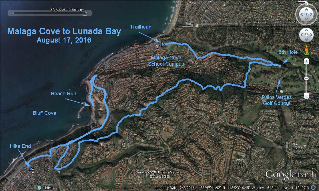
GPS Data (See Google Earth photo below):
Basic Hike (magenta): RT = 5.2 miles; Cum Elevation = 810 ft.
Optional Hike (green): RT = 7.4 miles; Cum Elevation = 1000 ft.
Directions to Trailhead: The trailhead is the parking lot and small road adjacent to the Peninsula Education Foundation office at 300 Paseo del Mar. Reach the trailhead by exiting the 405 freeway and heading South on Hawthorne Blvd. About half way up the Palos Verdes hill turn right on Palos Verdes Dr. North. Continue West 2.4 miles to the triangular intersection and bear left as Palos Verdes Dr. transitions from North to West. Continue a block through the Malaga Cove commercial district and turn right at Via Corta, which curves into Via Almar. Turn right from Via Almar onto Via Arroyo and after a block turn right into the parking lot and small road, which continues a few hundred feet. Rest rooms are available to the South, across the expanse of grass.
The Hike: A detailed map will be supplied on hike day. The Basic Hike is in one direction from the trailhead to the a house and the party. The hike begins up the small road, transitions to a trail, and then onto city streets as it progresses in front of the Malaga Cove commercial district. (From the open area look up the hill and you can see the cut for the fire road we will be on later.) Continue on Via Tejon to a large open area, bounded by Palos Verdes Drive North and Palos Verdes Golf Course on the East.
There are a multitude of trails in this open area. Stay along the crest until you reach the golf course and their Keep Out signs. Some may choose to return from here, but the main hike soon heads south up a heavy foliaged streambed, which is below power lines. After crossing below the bridge for Via Campesina, turn right and continue on the Paseo del Sol fire road, (its the cut seen earlier from below).
Continue as Paseo del Sol turns from a fire road to a real road and crosses Via del Monte. The Basic Hike continues up Paseo del Sol and turns downward on the trail after 1821 Paseo del Sol. The trail progresses to Palos Verdes Dr. West. Turn right, as the hike follows the median until it ends. Cross Palos Verdes Dr. West to the small parking lot and Viewpoint. The Basic Hike works West along the bluff to Avon Road. Go left up Avon Road to address 605; the blue house with white trim. From the Viewpoint the Rabbit Run turns right and progresses along the bluff, then residential streets, and then ultimately down a dirt path to the ocean at Bluff Cove. Rabbits must retrace their steps to the Viewpoint and rejoin the Basic Hike.
The Major Hike Option continues down Via del Monte from the junction with Paseo del Sol. Be careful, Via del Monte is a fairly busy street. Enter the access road to the La Venta Inn, a popular wedding venue and party spot. Bear right and merge with Via Somonte until, across from 820 Via Somonte take the downward path and stairs. Walk up Via del Monte and turn right and follow Via Arriba, and then the path and downward stairs across from 1704 Via Arriba. At the bottom of the stairs turn hard right and follow the path back to the Malaga Cove commercial district, and then retrace your steps back to the trailhead.
Party at 605 Avon Road. Bring a swimsuit if you would like to party in the spa. Please help with car shuttles from the party back to the trailhead.
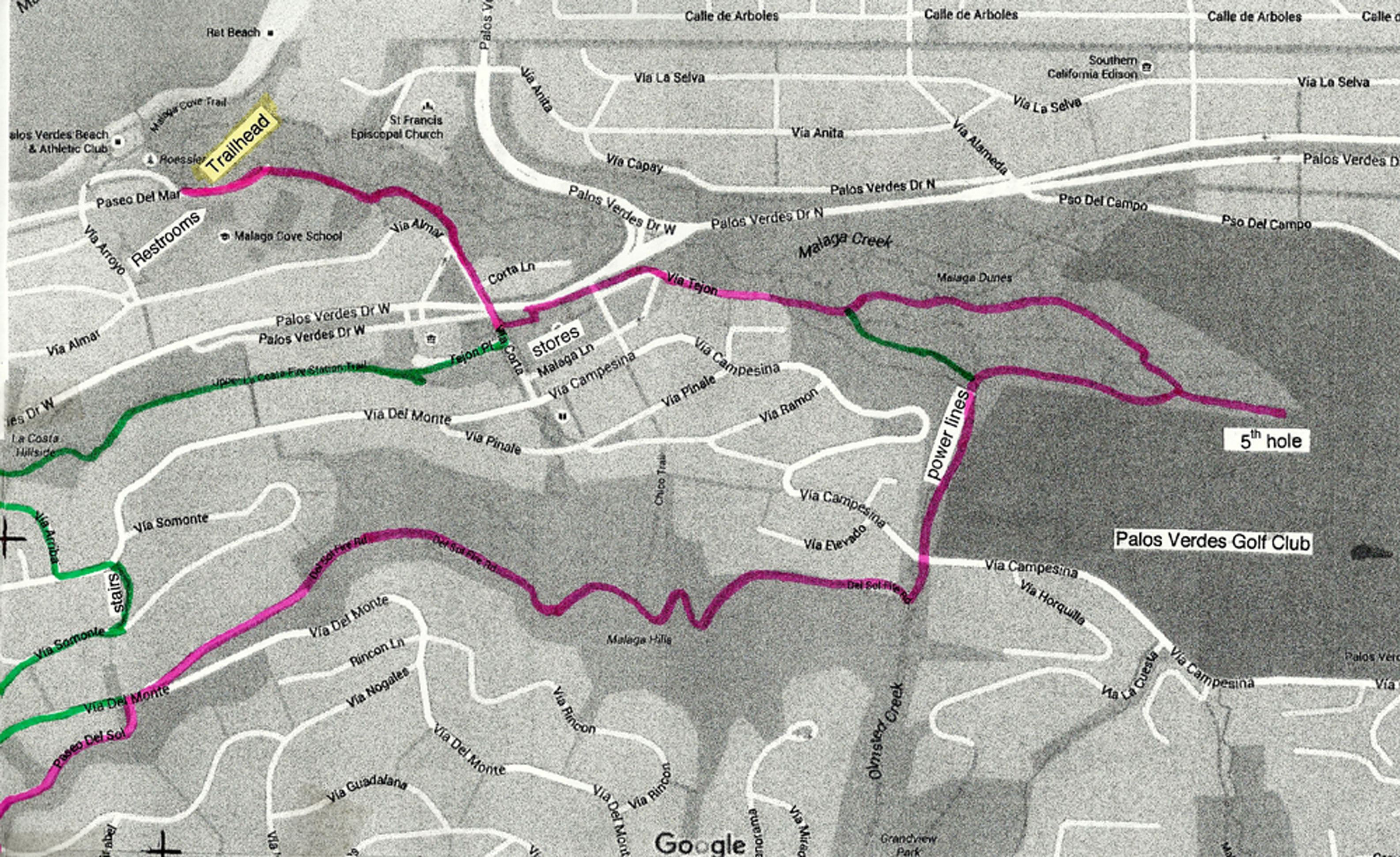
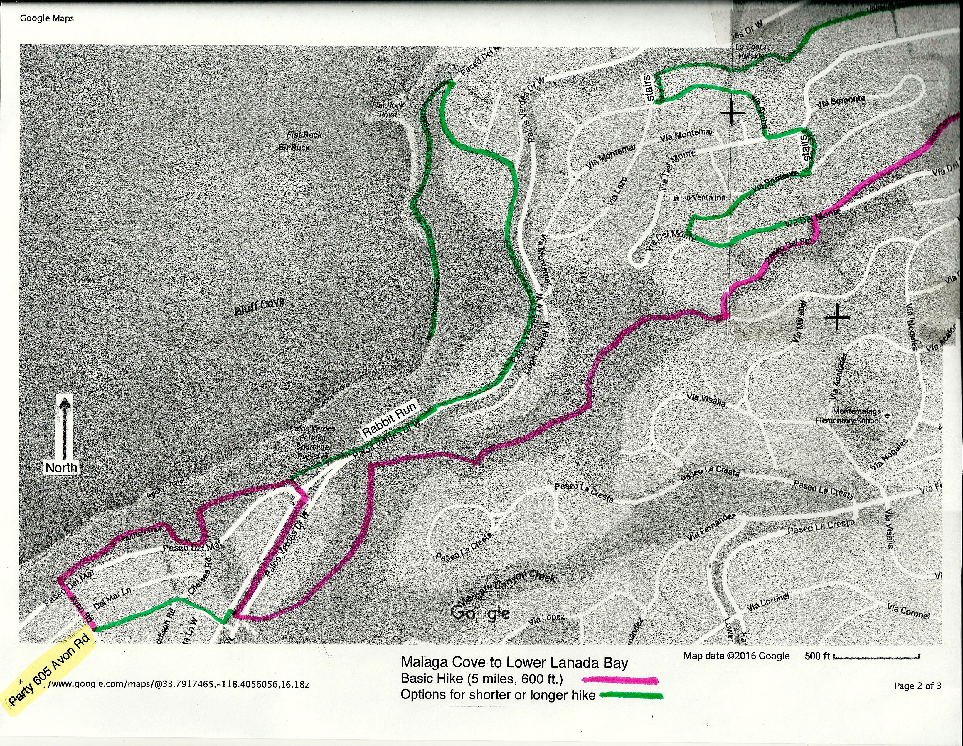
Detailed Map page 1 --- Detailed Map page 2
Print map pages in color if possible. Assemble map by overlaying page 1 lower left corner over page 2 upper right corner*. Major Hike Option is shown in magenta. Options for longer or shorter hikes shown in green.