Hike #1275
Three Points to Twin Peaks -or- Mt. Waterman
May 25, 2016
Jim Gardner, Hike Leader
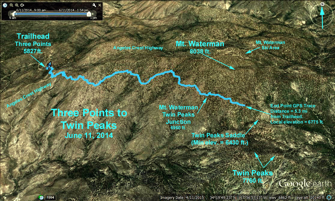
GPS Data (For trace shown on Google Earth Photo):
Trailhead elev. = 5827 ft.; Mt. Waterman/Twin Peaks Junction elev. = 7100 ft.
Distance to Junction = 4.7 mi one way, elev. gain = 1273 ft.
Distance: 5.3 mi one way to trace end point, 325 ft. loss from Junction.
Topo Data: Elev. at Junction = 6960 ft.
Min. Elev. at Twin Peaks Saddle (Stream) = 6430 ft.
Elevation published for Twin Peaks = 7760 ft.
Elevation published for Mt. Waterman = 8038 ft.
Trails of the Angeles Hike #59
Distance to Twin Peaks = 14 mi. RT, elev. gain = 3700 ft.
Distance to Mt. Waterman from Junction = 2 miles one way
Elev. Gain from Junction = 1200 ft.
Trailhead Directions: The trailhead is at Three Points on the Angeles Crest Highway 27 miles from the 210 freeway. At 2.4 miles past Chilao, turn left at the Santa Clara Divide Road and continue to the parking area which soon appears on the left. There are toilets available at the parking lot.
The Hike - CAUTION: From the log of two very fit and experienced hikers: "Distance to Twin Peaks: 14 miles RT, Elevation gain: 2610 ft. This is a long, strenuous hike! If you go all the way to the top of Twin Peaks it is between 14 and 15 miles. Starting at 9:00 AM, we got from the Three Points parking lot to Twin Peaks Saddle between Waterman and Twin Peaks (6 1/3 miles) in two hours. It took us another hour (with several pauses) to scramble to the top of the Peaks (there is no trail). After lunch we came down much faster, but there followed a good climb back up the Waterman slope from the saddle so that we returned to the parking lot (again with many rest stops) just short of 4:00 PM, seven hours! Total elevation gain and loss is in excess of 3000 feet. If anyone wants to do this entire hike, you must start no later than 8:30 in the morning, if not sooner, and double up on your water."
However, take heart. The trail is wonderful, as it passes through the wilderness. Views are magnificent. And there are good turnaround points. The first comes at roughly three miles as one passes through a low swamp grass area that literally obscures the trail. About a quarter of a mile further on one comes to an obvious beautiful viewpoint with a large mass of rocks. Lunch here and return. Not much elevation gain and about seven miles.The next obvious goal is the saddle. About 12 miles and maybe 1000 feet loss and gain. Beyond that the peak."
Alternate Hike: Hike to Mt. Waterman instead of Twin Peaks. The fork to the right at the Twin Peaks-Waterman Junction goes down to the Twin Peaks saddle, the fork to the left goes up to the peak of Mt. Waterman. Return to the trailhead the way you came.
Checkout pictures and trail description on hikespeak.com.