Hike #1271
Powder Canyon
April 27, 2016
Veronica Noguer, Hike Leader
Note: Walnut = Noguer (French) = Nogal (Spanish). What an appropriate hike!
Description of the Hike: There are a number of variations for this hike. The terrain is rolling hills going through fresh spring grass, Oak and Black Walnut Woodlands. Wild flowers may be in bloom at this time. Intermittent creeks parallel the trails in some areas.
Directions to Schabarum Trailhead: Go east on the Pomona Freeway (60). Exit at Azusa Ave. (exit #18) and go south to Colima; left on Colima; right into Schabarum Park. Drive straight past the guard booth and continue on the main park road (don't turn right). After about 0.6 mi. you will come to a "T" intersection. (Follow signs to Equestrian Area). Turn left and in another 0.2 mi. you will arrive at an equestrian area. Park on the right. Bathrooms and picnic tables are available at the park.
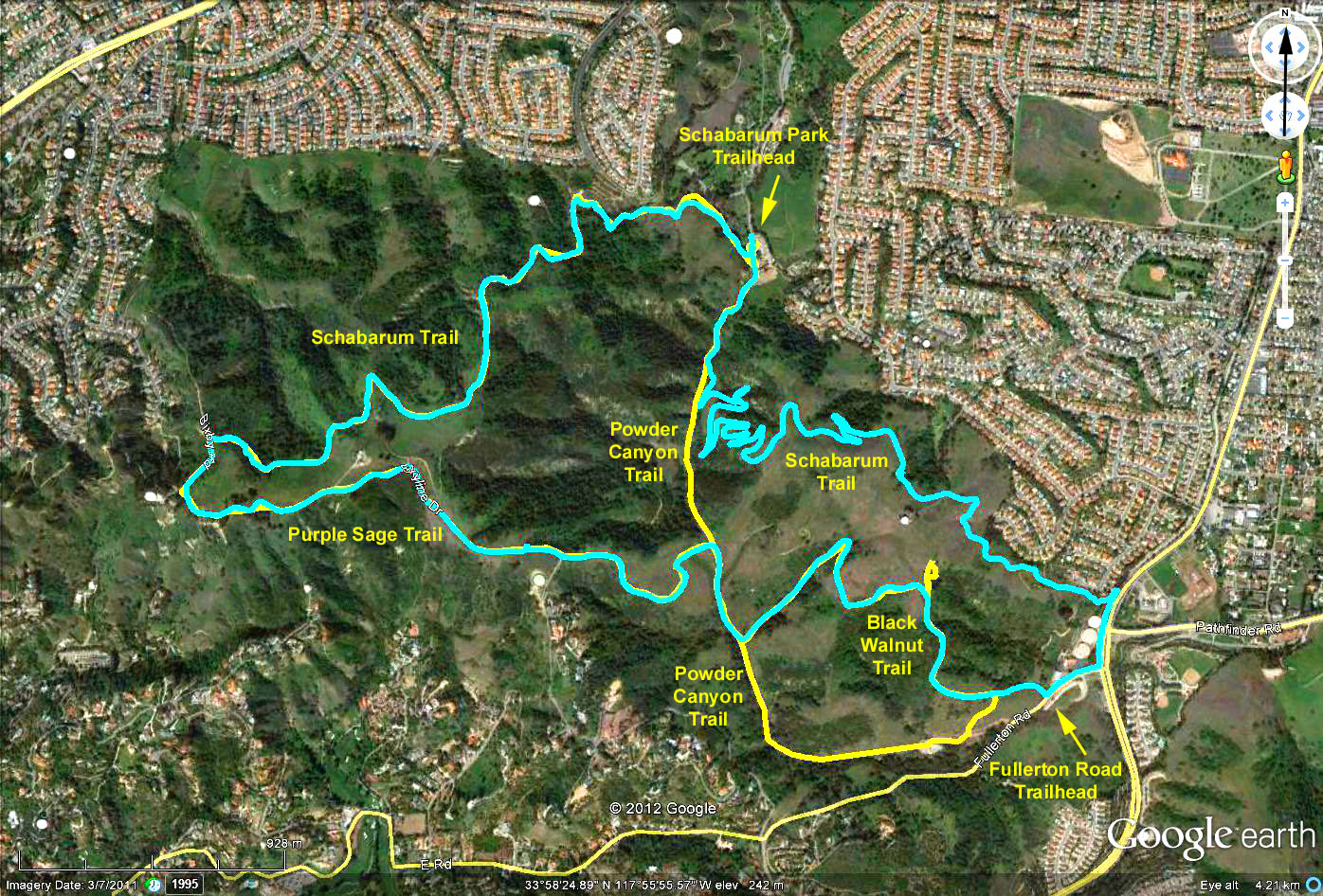
Basic Hike: 6.3 miles, about 1300 feet total elevation gain From the Schabarum Trailhead, head south on Powder Canyon Trail 0.8 miles to junction with the Black Walnut Trail on the left. Follow Black Walnut Trail 1.0 miles to turnoff to Nogales Trail (on the right). Take Nogales Trail a short .12 miles to join Powder Canyon Trail, which is a dirt road at this point. Right on Powder Canyon and continue for 0.8 miles to the junction (on the left) with the Purple Sage Trail. Go left and follow Purple Sage Trail for 0.9 miles. At the junction with Buena Vista Trail you will be facing a transmitter station above you.
Turn left and continue on the gravel road (Purple Sage trail) below the transmitter station for 0.5 miles to a clump of eucalyptus trees, just before a second set of antennas. This may be a good place for lunch break with shade and a nice view of the OC. Continue just beyond, and you will reach the intersection with the Schabarum trail. Turn right and follow this trail for 2.1 miles to return to the starting point. (Use caution after 0.7 miles on the Schabarum Trail to make sure you stay on it as you round an area with transmission towers). (Yellow line in Google Earth Photo)
Variations on the basic Hike:
a) Shorter Hike 1: 5.4 miles, about 1200 feet total elevation gain Follow Basic Hike above until you reach the junction of Purple Sage Trail and Buena Vista Trail. Proceed straight ahead on the Buena Vista Trail to join the Schabarum Trail without going around the transmitter hill.
b) Shorter Hike 2: 3.4 miles, about 550 feet total elevation gain Follow the Basic Hike above on its first loop: Powder Canyon, Black Walnut Trail, Nogales Trail and Powder Canyon. At the junction with Purple Sage Trail, continue on Powder Canyon to return to the start.
c) Longer Hike: 8.5 miles, about 1500 feet total elevation gain Start along Powder Canyon south, and at 0.2 miles turn left onto Schabarum Trail Extension. Follow trail for 2.7 miles to Fullerton Road. Proceed along Fullerton Road to the start of the Black Wanut Trail. Continue on Black Walnut Trail until you end at Powder Canyon Trail. Turn right and go 0.2 miles to junction with Purple Sage Trail. Turn left and follow instructions as in Basic Hike, above. (Blue Line in Google Earth Photo).