Hike #1262
Monrovia Canyon Park
February 24, 2016
Tom Kaczmarek, Hike Leader
GPS Data:
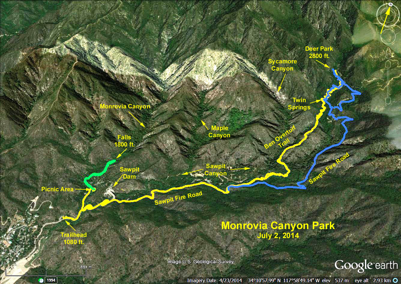
Waterfall Trail: RT = 2 mi., 70 ft. Max elevation change.
Ben Overturff Trail: Out and back via Sawpit Canyon - RT = 7.0 mi., 1500 ft. max elevation change.
Out via Sawpit Canyon, back via road - RT = 7.3 mi., max elevation change = 1500 ft.
Directions to Trailhead: Monrovia Canyon Park is located at 1200 N. Canyon Blvd. in the city of Monrovia. From the 210 freeway going either direction take the Myrtle Ave. exit and head north through Old Town Monrovia. In about a mile beyond Old Town, turn right onto Foothill Blvd. Travel four blocks then turn left onto N. Canyon Blvd. Follow signs to Monrovia Canyon Park. We will meet at the lower parking lot next to the ranger station. There is a $5 parking fee per car. Restrooms are available.
The hikes: There are two nice hikes in the park. Those desiring a short hike should take the waterfall trail up Monrovia Canyon. Those desiring a longer walk can take the Ben Overturff trail up Sawpit Canyon to Deer Park. Those desiring the grand tour can do both.
Ben Overturff Trail description: From the lower lot walk up the paved road passing the waterfall trail on the left. Continue up the road a short distance to a big sign marking the road to Trask Boy Scout Reservation. Turn right on this private road (hikers are allowed but no private vehicles). Hike up this steep paved road past a dam and the Boy Scout camp. After one mile the pavement ends and you are on a dirt fire road. In another half mile you reach the Ben Overturff trailhead on the left, marked by a sign and two low stone pillars just before a locked gate.
The trail first descends to cross the creek, then climbs steeply up to Twin Springs where flowing water from one of the springs has formed a natural bridge. You will pass two lateral trails back to the fire road. Follow signs to the Deer Springs cabin site, where Ben Overturff ran a resort and his wife Bertha served her famous lemon pie to hungry hikers. There is not much left of the cabin today.
You can follow the trail a bit further to view the remains of a stone barn and mule corral, but after that the trail peters out and you will soon find yourself bushwhacking. Return the way you came back to the last trail junction and follow the sign to the restroom located just off the fire road. At this point those desiring additional mileage and elevation gain can continue up the road to White Saddle and the maze of fire roads beyond. Most of us will turn right and descend the dirt road back to the park.
Waterfall Trail description: From the lower lot walk up the paved road to the signed trailhead on the left. This trail is very popular and easy to follow. It first climbs a small hill then follows the stream up Monrovia Canyon and ends at the falls. Along the way you will pass lateral trails to the middle and upper parking lots. Bear left at each of these junctions to continue upstream to the falls.
On the way back you can visit the Nature Center at the upper parking lot if you like. We will meet at the middle parking lot after the hike. Refreshments will be served on the picnic tables near the middle parking lot.