GPS Data: Distance = 7.8 mi RT from end of parking lot.
Elevation gain = 3258 ft.
CAUTION: This is a very strenuous hike. The trail is steep and unrelenting. Consider the total hiking time may be as much as 5 hours plus time for lunch and rest stops, all with reasonable temperatures. Crossing Big Tujunga Creek may be another problem depending on water level.
Trailhead Directions: Exit 210 Freeway at Lowell Ave. and head north to Foothill Blvd. Turn left and follow Foothill northwest perhaps 2 mi. to a 3-way intersection of Foothill, Summitrose and Mt. Gleason roads. Turn right (north) and follow Mt. Gleason Rd. up over the hill and down to Big Tujunga Canyon Road. Turn right on Big Tujunga Canyon Road and proceed to Doske Road (Wildwood Picnic area - mile paddle 2.92) on the right. If you get to Vogel Flat Road, you've gone too far!
For Valley people, exit the 210 at Sunland, turn left under the bridge and continue east on Foothill Blvd. to Oro Vista. Turn left, and drive north about 3 blocks to the end at Big Tujunga Canyon Road then follow the instructions above.
Descend Doske Rd. to Stoneyvale road, which runs along the canyon bottom and turn left (upstream). Park in the parking lot at the end of Stonevale road. There are restroom facilities nearby at the Wildwood Picnic area.
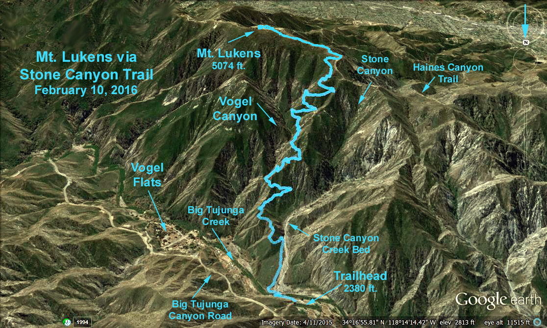
The Hike: The hike starts at the far end of the parking lot and continues upstream for perhaps 0.13 mi. At this point, the trail crosses the stream and then continues southerly into the mouth of Stone Canyon paralleling the dry bed of Stone Creek. After another 0.15 mi or so, the trail leaves the stream bed, and begins to zigzag steeply up the left ridge of Stone Canyon. In about 2 mi. we may see the remnants of a small stream and at 3.2 mi., we reach a fire road on the ridge northwest of the summit. Turn left and follow the path 0.6 mi. to the summit. After lunch, return the way you came.
Refreshments served in the Wildwood Picnic area.
Google Earth Photo - Mt. Lukens via Stone Canyon
Please checkout hiker's comments (i.e. wear long pants), gpx and kmz files available from this site: Modern Hiker's Report on the Stone Canyon Hike