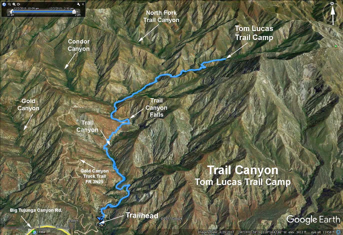
Hike #1253
Trail Canyon Trail to Tom Lucas Trail Camp
December 2, 2015
Jim Spotts, Hike Leader
HIKE DETAILS: 8.6 mi. round trip, est. 2000 feet total ascent. It is an out and back, for a shorter hike turn around as you see fit.
DIRECTIONS TO THE TRAILHEAD: From the 210 freeway take the Sunland exit and go East on Foothill Blvd. Go approx. 1.6 miles east on Foothill and turn left on Mt. Gleason Blvd. NOTE: There are no restroom facilities at the trailhead. There is a Mc Donalds on the right shortly before we turn on Mt. Gleason Blvd. Go north on Mt. Gleason approx. 1.1 mi. (the last 0.1 mile is a jog to the left) and turn right on Big Tujunga Canyon Road.
You then go approx. 3.4 mi. to where there is a dirt turnoff on the lefthand (north) side. It is at milepost 2.04. It isnt really marked well so be watchfull. From the dirt area you have arrived at, take the dirt road approx. 0.5 mi. to a parking area and the trailhead. The road is a little rough but quite passible.
THE HIKE: We walk past the gate and follow an old road that passes some cabins. After about 0.6mi. you leave the road and start on the trail. You start along the creek and then leave the creek bed to climb over the Trail Canyon Falls. (I did not see the dry falls, nor their location on my short scouting hike). The trail now drops into the canyon to continue our hike to the Trail Camp. There is some boulder hopping but the trail continues on OK. I have to admit that in the several times that I did this hike in the hiking groups early days, I never went as far as the Trail Camp. It is a tiring hike but I feel sure that at least the Tigers will make it. It is an enjoyable hike even if you dont go all the way up to the trail camp.
Refreshments will be at the trailhead. BRING CHAIRS IF YOU CAN.
Google Earth - Tom Lucas Trail Camp
HikeSpeak - Trail Canyon Falls
2017-07-18