Hike #1239
August 19, 2015
Three Canyon Park Hike Franklin, Fryman and Wilacre
Vicky Ritter, Hike Leader
Background: These are beautiful canyons filled with sycamore and oak trees located between ridges of the St. Monicas between Coldwater canyon and Laurel Canyons. Two separate hikes are proposed: Franklin Canyon, and a combination of Wilacre and Fryman Canyons. Both involve a combination of residential streets, dirt trails and fire roads. Hikers can chose to do one hike or the other, rabbits might try doing both.
Directions to the Trailhead: From US 101 exit Coldwater Canyon Ave. Go south 2.5 miles to the intersection of Coldwater Canyon Ave. and Mulholland Drive and make a ninety degree angle right turn (west) onto Franklin Canyon Drive - a small residential street set back from the larger intersection. Drive through the neighborhood approximately 0.5 miles and you will enter Franklin Canyon Park. CAUTION: Be aware that there are cameras at some stop signs. Be sure to make complete stops at every stop sign, just to make sure. Turn left after the stop sign and park in the adjacent large lot. Refreshments will be served in the picnic area above and south of the parking lot.
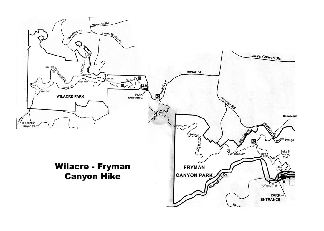
Wilacre-Fryman Canyon Hike. GPS: 5.4 mi. RT, 400 ft. max elevation change. Proceed north of the parking lot on the Berman Trail, a steep up and down trail which parallels the road into the canyon (use of the road is an easier option, but adds 0.2 mi.), ultimately climbing to Mulholland Dr. Follow Mulholland north to its intersection with Cold Water Canyon Blvd. Cross both streets with the light and, proceeding past the Tree People establishment, look for a set of stairs on the left covered in rock masonry. Turn right at the bottom and walk a short distance to another set of stairs on the left, descend these and turn right again. This path ends at a T intersection, a large open area with information signs and a water fountain. Turn right and walk through Wilacre Park on the dirt U-Vanu Trail, ultimately arriving at the "park entrance" where the dirt road empties into the Iredell Lane cul-du-sac. (There is a choice of turning left at the T and lengthening the hike by using the Betty B. Deering Trail. This was not checked out, but Google Earth indicates that it may take you to Fryman Road instead - head south).Walk ahead on residential Iredell Lane turning right when it ends at Iredell St. Continue on Iredell St. turning right ultimately onto Fryman Road. Continue south-easterly until the Fryman Rd. ends and is blocked by a yellow gate at Dona Maria St. Continue through the gate on Briarcrest Fire Road. Just before reaching an intersection with another fire road, look for a defined trail on the right signified by logs on each side. This the extension of the Betty B. Deering trail. There are numerous side trails which appear to return to the main trail but stay on the trail to the so-called rain forest.
The trail descends the canyon, then climbs out eventually arriving at a T intersection where a sign says Iredell 0.9 mi. You turn left and proceed out to the Iredell Lane cul-du-sac via the Barker Fire Trail. Look for the dirt Wilacre trail and retrace your steps back to the intersection of Coldwater Canyon Blvd. and Mulholland, cross at the light, and return to the Franklin Canyon parking lot either by the Berman trail or the entrance road.
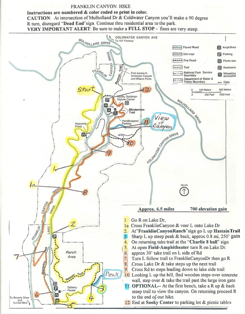
Franklin Canyon Hike. GPS: 5.8 mi. RT, 600 ft. max elevation change. The only trails that are clearly marked are the Hastain Trail and the Discovery trails. In the upper canyon there will be several lookouts and trails around the lake. As we go down to the lower canyon we will descend about 200 ft before arriving at the clearly marked Hastain trail.
We start by walking up above the parking lot on the entrance road to the beginning of a weaving fire road (signified by two large boulders on each side) which takes us to Franklin Canyon Drive. This drive leads us to The Hastain Trail on our left. We climb the Hastain to the ridge, then a short up and back climb up to the peak overlook. We descend down to the Lake Drive, then soon after proceed on the Discovery Trail to Franklin Canyon Drive, then back up-canyon on various trails past the lake then back to the Sooky Center and the parking lot for refreshments.