Hike 1223
April 29, 2015
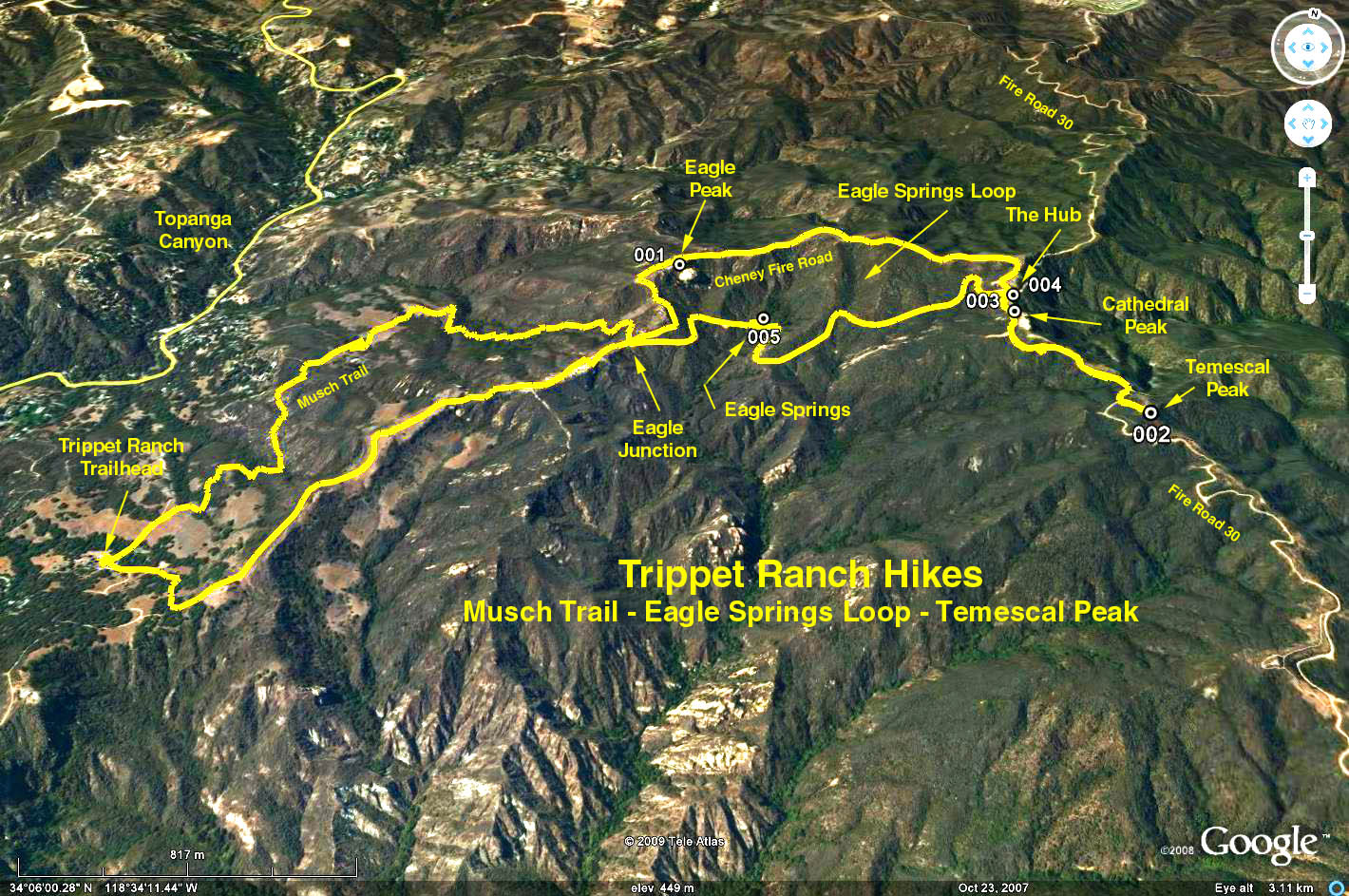
Trippet Ranch East to the Hub, Cathedral and Temescal Peaks
Ralph Shoukry, Hike Leader
GPS Data:
Total Hike RT = 8.2 mi.; elevation gain = 1925 ft.
One Way Incremental Distances:
Musch Trail - Trippet to Eagle Juncton = 2.2 mi.; 450 ft.
Fire Road - Trippet to Eagle Junction = 1.5 mi.; 450 ft.
Cheney FR - Eagle Junction to Hub via Eagle Peak = 1.5 mi.; 340 ft.
Eagle Springs TR - Eagle Junction to Hub via Eagle Springs = 1.5 mi; -360 ft.
RT hub to Temescal Peak = 1.3 mi.; 130 ft.
Summary: There are two ways to hike east out of Trippet, on the fire road and on the Musch Trail. They meet at Eagle Junction, and beyond this to the east is the Eagle Springs Loop which terminates at the Hub, a junction of Fire Road 30, Cheney Fire Road (upper portion of the loop including Eagle Peak), and Eagle Springs Trail (the lower portion of the loop past Eagle Springs). Extending beyond the Hub, accessible on Fire Road 30, are Cathedral Peak and then Temescal Peak. Many hikes have been formed from combinatios of these trails and destinations.
Directions to Trailhead: From Topanga Canyon Blvd, just north of the town of Topanga, turn east on Entrada Road. Once on Entrada Road turn left at every street intersection, 1.1 miles to the entrance of Topanga State Park (Trippet Ranch). There is a fee for parking. Restrooms at the parking lot.
The Hike: The hike starts on the fire road, turns left at Eagle Junction, climbs Eagle Peak, continues to the hub, and beyond, climbing Cathedral and Temescal Peaks, back tracks to the hub, then returns to the trailhead via Eagle Springs and the Musch Trail.
Take the trail up the hill from the parking lot. This intersects with a fire road. Turn left at this intersection and walk up a gentle grade, initially in the shade of Coast Live Oak trees - later along an open ridge. Continue on the road for about 1 mile to a fork, Eagle Junction; take the left fork of the fire road and continue uphill, noting the view of Eagle Rock ahead. Make a short side trip on the back side to climb up Eagle Rock.
Continue east on the road (Cheney Fire Road), until reaching an intersection with three roads, called "The Hub." Besides the Cheney Fire Road, there is Fire Road 30 entering on the left, and continuing southward. Turning sharply to the right, another road that passes Eagle Springs going west which we will take later.
Go south on Fire Road 30 almost immediately past Cathedral Peak, then after about 1/2 mile to the intersection with Rogers Road on the left. Continue a short distance south of this intersection, leave the road and climb Temescal Peak, the highest point in the Park, 2126 feet.
Return to the Hub the same way you came. Turn left and go to Eagle Spring which is supposed to be a year round spring. Then continue west on the road until coming to Eagle Junction. Cross the road to the west side where you will find the Musch Ranch Trail. Continue south on the trail heading down through the chaparral, oaks, and a little stream that flows after each rain. Cross a little meadow, pass the pond, and you have arrived at the parking lot.
Google Earth photo - Hub, Cathedral Peak & Temescal Peak from Trippet Ranch